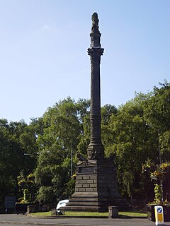
Battlefield, Glasgow
Battlefield
| |
|---|---|
 Battlefield Monument, Glasgow | |
Location within Glasgow | |
| OS grid reference | NS579614 |
| Council area | |
| Lieutenancy area |
|
| Country | Scotland |
| Sovereign state | United Kingdom |
| Post town | GLASGOW |
| Postcode district | G42 |
| Dialling code | 0141 |
| Police | Scotland |
| Fire | Scottish |
| Ambulance | Scottish |
| UK Parliament | |
| Scottish Parliament | |
Battlefield is a

Housing consists mainly of three and four-storey Victorian and Edwardian
Battlefield was formerly a centre of Glasgow's
The area includes one of Glasgow's main hospitals, the New Victoria Hospital (and the buildings of the (old) Victoria Infirmary), and further education institutions, Langside College. Another key local landmark, the Battlefield Rest building and clocktower, is now a restaurant, as is The Church on the Hill, previously the Langside Hill Church.[2]
Langside Library, at the junction of Sinclair Drive and Battlefield Road, is the final Carnegie library in Glasgow.
The Southside Festival takes place in Queens Park in May annually. It celebrates the cultural diversity and uniqueness of the Southside of the city.
References
- The Royal Commission on the Ancient and Historical Monuments of Scotland. Retrieved 9 July 2009.
- ^ "Langside Hill Church". TheGlasgowStory. Retrieved 3 October 2017.

