
Bighorn National Forest
| Bighorn National Forest | |
|---|---|
 The Medicine Wheel National Historic Landmark in the National Forest | |
  | |
| Location | Sheridan, Big Horn, Johnson, and Washakie counties, Wyoming, USA |
| Nearest city | Sheridan, WY |
| Coordinates | 44°32′N 107°21′W / 44.533°N 107.350°W |
| Area | 1,107,571 acres (4,482.18 km2)[1] |
| Established | February 22, 1897[2] |
| Governing body | U.S. Forest Service |
| Website | Bighorn National Forest |
The Bighorn National Forest is a
Within the forest is the
The forest headquarters is located in
also has a ranger station, visitor accommodation, and campgrounds.History
The Bighorn National Forest was established as the Big Horn National Forest on 22 February 1897, and encompasses 1,198,080 acres. On 1 July 1908 the name was changed to the Bighorn National Forest through an executive order. In September 1981 the national forest had 1,115,171 acres, with 1,107,670 of those acres being National Forest land.[7]

Climate
According to the
| Climate data for Burgess Junction, Wyoming, 1991–2020 normals, extremes 1960–present | |||||||||||||
|---|---|---|---|---|---|---|---|---|---|---|---|---|---|
| Month | Jan | Feb | Mar | Apr | May | Jun | Jul | Aug | Sep | Oct | Nov | Dec | Year |
| Record high °F (°C) | 57 (14) |
56 (13) |
57 (14) |
70 (21) |
75 (24) |
87 (31) |
88 (31) |
88 (31) |
81 (27) |
74 (23) |
65 (18) |
55 (13) |
88 (31) |
| Mean maximum °F (°C) | 46.7 (8.2) |
45.7 (7.6) |
50.0 (10.0) |
57.8 (14.3) |
67.2 (19.6) |
74.8 (23.8) |
81.1 (27.3) |
79.8 (26.6) |
75.8 (24.3) |
65.5 (18.6) |
53.2 (11.8) |
46.1 (7.8) |
82.0 (27.8) |
| Mean daily maximum °F (°C) | 29.8 (−1.2) |
29.4 (−1.4) |
35.2 (1.8) |
40.5 (4.7) |
49.8 (9.9) |
61.4 (16.3) |
70.8 (21.6) |
69.7 (20.9) |
60.6 (15.9) |
46.3 (7.9) |
35.6 (2.0) |
28.6 (−1.9) |
46.5 (8.0) |
| Daily mean °F (°C) | 18.9 (−7.3) |
18.1 (−7.7) |
23.8 (−4.6) |
29.4 (−1.4) |
38.9 (3.8) |
48.4 (9.1) |
56.4 (13.6) |
55.4 (13.0) |
46.9 (8.3) |
34.6 (1.4) |
25.2 (−3.8) |
18.4 (−7.6) |
34.5 (1.4) |
| Mean daily minimum °F (°C) | 8.1 (−13.3) |
6.7 (−14.1) |
12.5 (−10.8) |
18.3 (−7.6) |
28.0 (−2.2) |
35.4 (1.9) |
41.9 (5.5) |
41.0 (5.0) |
33.2 (0.7) |
22.9 (−5.1) |
14.7 (−9.6) |
8.1 (−13.3) |
22.6 (−5.2) |
| Mean minimum °F (°C) | −15.2 (−26.2) |
−16.5 (−26.9) |
−8.2 (−22.3) |
0.3 (−17.6) |
12.7 (−10.7) |
25.5 (−3.6) |
32.3 (0.2) |
30.7 (−0.7) |
19.0 (−7.2) |
1.3 (−17.1) |
−9.4 (−23.0) |
−16.3 (−26.8) |
−25.5 (−31.9) |
| Record low °F (°C) | −44 (−42) |
−45 (−43) |
−24 (−31) |
−18 (−28) |
0 (−18) |
5 (−15) |
21 (−6) |
20 (−7) |
−5 (−21) |
−22 (−30) |
−28 (−33) |
−48 (−44) |
−48 (−44) |
| Average precipitation inches (mm) | 1.42 (36) |
1.67 (42) |
2.08 (53) |
2.79 (71) |
3.50 (89) |
2.41 (61) |
1.57 (40) |
1.20 (30) |
2.02 (51) |
2.30 (58) |
1.62 (41) |
1.54 (39) |
24.12 (611) |
| Average snowfall inches (cm) | 31.7 (81) |
32.6 (83) |
35.3 (90) |
36.8 (93) |
19.3 (49) |
3.3 (8.4) |
0.0 (0.0) |
0.1 (0.25) |
6.3 (16) |
24.3 (62) |
27.7 (70) |
31.9 (81) |
249.3 (633.65) |
| Average precipitation days (≥ 0.01 in) | 10.1 | 9.3 | 10.4 | 12.0 | 9.3 | 6.3 | 4.9 | 7.2 | 4.7 | 8.7 | 8.8 | 9.9 | 101.6 |
| Average snowy days (≥ 0.1 in) | 10.1 | 9.2 | 9.8 | 10.4 | 5.5 | 0.9 | 0.0 | 0.0 | 1.8 | 6.5 | 8.8 | 9.7 | 72.7 |
| Source 1: NOAA[8] | |||||||||||||
| Source 2: National Weather Service[9] | |||||||||||||
Bald Mountain is a small peak on the northern plateau of the Bighorn Mountains.
| Climate data for Bald Mountain, Wyoming, 1991–2020 normals: 9380ft (2859m) | |||||||||||||
|---|---|---|---|---|---|---|---|---|---|---|---|---|---|
| Month | Jan | Feb | Mar | Apr | May | Jun | Jul | Aug | Sep | Oct | Nov | Dec | Year |
| Mean daily maximum °F (°C) | 22.8 (−5.1) |
24.3 (−4.3) |
33.4 (0.8) |
40.2 (4.6) |
49.0 (9.4) |
56.9 (13.8) |
66.0 (18.9) |
64.6 (18.1) |
54.3 (12.4) |
39.8 (4.3) |
28.7 (−1.8) |
21.6 (−5.8) |
41.8 (5.4) |
| Daily mean °F (°C) | 16.4 (−8.7) |
16.7 (−8.5) |
24.1 (−4.4) |
30.0 (−1.1) |
39.1 (3.9) |
47.0 (8.3) |
55.4 (13.0) |
54.2 (12.3) |
45.2 (7.3) |
32.4 (0.2) |
22.2 (−5.4) |
15.5 (−9.2) |
33.2 (0.6) |
| Mean daily minimum °F (°C) | 9.9 (−12.3) |
9.1 (−12.7) |
14.8 (−9.6) |
19.8 (−6.8) |
29.1 (−1.6) |
37.1 (2.8) |
44.8 (7.1) |
43.8 (6.6) |
36.2 (2.3) |
24.9 (−3.9) |
15.7 (−9.1) |
9.4 (−12.6) |
24.5 (−4.1) |
| Average precipitation inches (mm) | 2.64 (67) |
2.51 (64) |
2.81 (71) |
3.50 (89) |
3.81 (97) |
3.44 (87) |
1.34 (34) |
1.13 (29) |
2.20 (56) |
2.82 (72) |
2.37 (60) |
2.34 (59) |
30.91 (785) |
| Source 1: XMACIS2[10] | |||||||||||||
| Source 2: NOAA (Precipitation)[11] | |||||||||||||
The SNOTEL weather station, Bone Springs, is slightly north of Cedar Mountain.
| Climate data for Bone Springs Div, Wyoming, 1991–2020 normals: 9350ft (2850m) | |||||||||||||
|---|---|---|---|---|---|---|---|---|---|---|---|---|---|
| Month | Jan | Feb | Mar | Apr | May | Jun | Jul | Aug | Sep | Oct | Nov | Dec | Year |
| Mean daily maximum °F (°C) | 24.3 (−4.3) |
25.8 (−3.4) |
33.6 (0.9) |
39.3 (4.1) |
48.1 (8.9) |
56.7 (13.7) |
65.5 (18.6) |
63.9 (17.7) |
54.0 (12.2) |
40.8 (4.9) |
30.1 (−1.1) |
23.1 (−4.9) |
42.1 (5.6) |
| Daily mean °F (°C) | 16.7 (−8.5) |
17.0 (−8.3) |
23.8 (−4.6) |
29.2 (−1.6) |
38.3 (3.5) |
46.6 (8.1) |
54.7 (12.6) |
53.4 (11.9) |
44.7 (7.1) |
32.5 (0.3) |
22.5 (−5.3) |
15.8 (−9.0) |
32.9 (0.5) |
| Mean daily minimum °F (°C) | 9.1 (−12.7) |
8.2 (−13.2) |
14.0 (−10.0) |
19.2 (−7.1) |
28.5 (−1.9) |
36.6 (2.6) |
43.8 (6.6) |
42.9 (6.1) |
35.3 (1.8) |
24.2 (−4.3) |
14.9 (−9.5) |
8.6 (−13.0) |
23.8 (−4.5) |
| Average precipitation inches (mm) | 2.24 (57) |
2.25 (57) |
2.79 (71) |
3.47 (88) |
3.92 (100) |
2.84 (72) |
1.59 (40) |
1.32 (34) |
2.50 (64) |
2.81 (71) |
2.07 (53) |
2.12 (54) |
29.92 (761) |
| Source 1: XMACIS2[12] | |||||||||||||
| Source 2: NOAA (Precipitation)[13] | |||||||||||||
Ecology and recreation
The Bighorn National Forest contains primarily forest along with alpine meadows and lakes at higher elevations. The forest is primarily
Gallery
-
 Sage Grousein Bighorn National Forest
 -
 A moose cow and her calf near the Shell Ranger Station
 -
 A northern flicker in a tree
 -
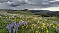 Wildflowers blooming in the short high altitude summer
 -

-

-


References
- ^ "Land Areas of the National Forest System" (PDF). U.S. Forest Service. January 2012. Retrieved June 30, 2012.
- ^ "The National Forests of the United States" (PDF). Forest History Society. Retrieved July 30, 2012.
- ^ a b wohl, Ellen; cooper, david; Poff, LeRoy; Rahel, Frank; Staley, Dennis; Winters, David. "Assessment of Stream Ecosystem Function and Sensitivity in the Bighorn National Forest, Wyoming" (PDF). Archived from the original (PDF) on 2016-03-04. Retrieved 2012-10-21.
- ^ Forest Service
- ^ "USFS Ranger Districts by State" (PDF). Archived from the original (PDF) on 2012-01-19. Retrieved 2009-05-20.
- ^ "Burgess Junction Visitor Center". USDA Forest Service: Bighorn National Forest. Retrieved 23 November 2014.
- ^ "The National Forests of the United States" (PDF). Forest History Society. Retrieved July 30, 2012.
- ^ "U.S. Climate Normals Quick Access". National Oceanic and Atmospheric Administration. Retrieved August 4, 2022.
- ^ "NOAA Online Weather Data". National Weather Service. Retrieved August 4, 2022.
- ^ "xmACIS2". National Oceanic and Atmospheric Administration. Retrieved October 12, 2023.
- ^ "Bald Mountain, Wyoming 1991-2020 Monthly Normals". Retrieved October 12, 2023.
- ^ "xmACIS2". National Oceanic and Atmospheric Administration. Retrieved October 12, 2023.
- ^ "Bone Springs Div, Wyoming 1991-2020 Monthly Normals". Retrieved October 12, 2023.
Further reading
- Georgen, Cynde (2010). In the Shadow of the Bighorns: A History of Early Sheridan and the Goose Creek Valley of Northern Wyoming. Sheridan, Wyoming: Sheridan County Historical Society. ISBN 978-0-9792871-7-6.
External links
- Bighorn National Forest - U.S. Forest Service