
Bransfield Basin
| Bransfield Basin | |
|---|---|
 Bathymetry map of the Bransfield Basin created using Geomap App software with a bathymetry map overlay with a distance and elevation scale. | |
| Type | Back-arc basin |
| Location | |
| Region | Northwest of the Antarctic Peninsula |
| Type section | |
| Country | Antarctica |
The Bransfield Basin is a
Tectonic development
The Bransfield Basin is considered to be a
[6][7] It is believed that the Phoenix plate stopped subducting under the Antarctic plate at least 4 million years ago during the Pliocene.[3][5][6][7] Once the subduction ceased, it is believed that the extension that created the basin was initiated. Aeromagnetic surveys have provided evidence that the extension occurred 1.8 million years ago during the Pleistocene at a rate of 0.25 to 0.75 centimetres (1⁄10 to 3⁄10 inch) per year.[7]It is widely accepted that the Bransfield Basin formed from extension caused by
There are 10 identified volcanoes along the 300 km long
Geology
.png)
The main factor that controls deposition inside the Bransfield Basin is glacial cyclicity. Additional contributing factors include physiography, tectonics, and oceanography.[1][10] Three stratigraphic units have been identified on the margins. The oldest unit is an over- consolidated diamicton from subglacial processes. The middle unit is a pebbly-sandy stratified mud from the proximal-ice or sub-ice shelf. The youngest unit consists of diatomaceous mud originating from open marine conditions. Sedimentary systems occur on the margins that are related to glacial and glacial marine, mass wasting, seabed fluid-escape, and contour current processes.[10]
Glacial processes
Glacial processes have deposited a subglacial deformation till. The sediment that makes up this unit is derived from pressure melting of the glacier and from the substrate the glacier passed over. The subglacial deformation till unit is composed of a matrix-supported diamicton.[10]
Glacial marine processes
Glacial marine processes have deposited two different units within the region. One of the units comprises proglacial debris flows have deposited a matrix-supported diamicton with interbeds of
Open marine processes
Open marine processes have deposited three units within the region. One of the units is a fining-upwards turbidity current deposit can be observed within the lower slope of the basin. Layers of volcanic ash around 1 to 4 centimetres (1⁄3 to 1+2⁄3 inches) thick are within the deposit. Another unit is a contorted/disturbed mud that makes up a slide unit. This unit is distinct because its angular contacts and disturbed structures that form from sediment reworking and plastic deformation from sliding. The third unit is a stratified mud with clast layers at the lower slope's foot. This unit is deposited from contour currents, and differences in clast size is attributed to shifting current conditions.[10]
Magmatism
The subduction event between the Phoenix plate and the Antarctic plate have built a volcanic arc consisting of low potassium to medium potassium content along the Antarctic Peninsula and South Shetland Islands. Volcanism occurred in multiple events during 130–110, 90–70, 60–40, and 30–20 million years ago. The paucity can be interpreted as subducting younger crust or subsidence the post 20 million years arc after the basin formed.[8] Volcanism is widespread within the Quaternary which created a series of submarine volcanoes. The submarine volcanoes produce glassy lavas ranging in compositions similar to what would be expected in arcs higher in large-ion lithophile elements to enriched mid-ocean ridge basalts.[8]
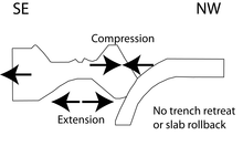
The Bransfield Basin is abnormal when it comes to the style of volcanism that can be observed within the basin. Undersea volcanoes experience what is called
The occurrence of incipient seafloor spreading in the basin is under controversy. Some researchers suggest that it does not occur within the basin because of the crustal thickness, magnetic anomaly patterns, and intracrustal diapirism.[2] Other geoscientists suggest that it is occurring and is related to seamount volcanism and normal faulting within the basin.[1][2]
Seismic swarm of 2020-2021
In August 2020, the largest
See also
- Adare Basin
- Geology of the Antarctic Peninsula
- Bransfield Strait
- Back-arc basin
- Antarctica
- Oceanic basin
- Glacial period
- Subduction
- Seafloor spreading
- Shetland Plate
References
- ^ S2CID 128997272.
- ^ .
- ^ S2CID 129748547.
- S2CID 128553161.
- ^ a b c Lawver, Lawrence; Keller, Randall; Fisk, Martin; Strelin, Jorge (1995). Backarc Basins: Tectonics and Magmatism. New York: Plenum Press. pp. 316–342.
- ^ a b c Galindo-Zaldivar, Jesus; Gamboa, Luiz; Maldonado, Andres; Nakao, Seizo; Bochu, Yao (2006). Antarctica: Contributions to global earth sciences. New York: Spring-verlag. pp. 243–248.
- ^ S2CID 129897434.
- ^ .
- ISBN 9780521372664.
- ^ .
- ^ S2CID 129797781.
- S2CID 245450444.
- ^ S2CID 248071330.