
Brewster, Massachusetts
Brewster, Massachusetts | ||
|---|---|---|
 Linnell Landing Beach, on Cape Cod Bay | ||
|
FIPS code 25-07980 | | |
| GNIS feature ID | 0618249 | |
| Website | www | |
Brewster /ˈbruːstər/ is a town in Barnstable County, Massachusetts, United States, Barnstable County being coextensive with Cape Cod. The population of Brewster was 10,318 at the 2020 census.[1]
Initially settled in 1659, the Town of Brewster is named after Elder William Brewster, the religious leader of Plymouth Colony. Brewster is known as the "Sea Captain's Town" for its wealth of eighteenth and nineteenth century historic captain's homes, including the Cobb House (1799), the current home of the Brewster Historical Society.[2][3]
Brewster is also notable as the home of Nickerson State Park, a 1,900 acre preserve carved out of the former hunting grounds of the prominent Nickerson Family.[4][5] The impact of the Nickerson Family can be seen at the Nickerson Mansion, now the home of Ocean Edge Resort. Constructed in 1890, the structure known as Fieldstone Hall was considered one of the most expensive houses built in the country at that time.[4]
The town is a popular summer destination, with the town population increasing to 30,000.[6] It also contains two National Historic Districts: Brewster Old King's Highway Historic District and Stony Brook–Factory Village Historic District, both listed on the National Register of Historic Places.[7]
Brewster is twinned with the town of Budleigh Salterton in the United Kingdom.
History
Early history

Indigenous settlement in Brewster took place on the north shore of the present-day town, with a Sauguatuckett farming area centered around the contemporary Stony Brook.

Brewster's first settlers came from Sandwich, Plymouth, and Eastham, as well as many arriving directly from England.[8] Throughout the 1700s, there were interspersed agricultural settlements throughout the area now known as Brewster. The Stony Brook gristmill remains as a testament to the early manufacturing activity at this site.[11] In 1709, a public house and store existed, with a congregational church and meeting house first organized in 1700.[8] By 1750, there were around 190 settlers living in the Brewster environs.[8] The remaining indigenous population in Brewster consolidated around the southwestern corner of the town.[8] Settlers and indigenous people alike utilized the abundant cornfields, as well as the natural resources of Cape Cod Bay. Substantial amounts of herring, or alewife, were, and continue to be, found in the Stony Brook area.[8]
Nineteenth century
Brewster was officially incorporated as its own town in 1803 when the less wealthy citizens of Harwich were upset that the town's institutions were all concentrated on Brewster's Main Street, now Route 6A, including the town hall and churches. Brewster was named in honor of Elder William Brewster, the first religious leader of the Pilgrims at Plymouth Colony.
By this period, roughly 75% of town inhabitants were involved in shipping and maritime trades.[8] Brewster captains invested an estimated $250,000 on merchant vessels, and a large saltworks was present on the shoreline of Cape Cod Bay during this period.[8] In 1865, Brewster maintained 56 farms, the highest of any town on the Lower Cape aside from Orleans. At this time, Brewster also had the third highest number of cranberry bogs on the Cape, following Harwich and Dennis.[8] Architecturally, Brewster blossomed during this period, with wealthy sea captains and commercial titans constructing Italianate, Greek Revival, and Second Empire homes. The most emblematic structure of this period is Albert Crosby's 1888 Crosby Mansion, located on Crosby Lane.[12]
Sites of historical interest
- Cape Cod Museum of Natural History
- Stony Brook Grist Mill (1873)
- Dillingham House (1660)
- Nickerson Mansion (1906)
- Old Higgins Farm Windmill (1795)
- Crosby Mansion (1888)
Gallery
-
 Brewster Station, built by Old Colony Railroad in 1860s, demolished in 1930s
 -
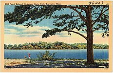 Postcard featuring Cliff Pond in Nickerson State Park
 -
 Captain Elijah Cobb House, present home of Brewster Historical Society (1799)
 -
 Harris Black House (1795)
 -
 Captain Elijah Cobb, a Brewster sea captain
 -
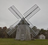 Old Higgins Farm Windmill, on the National Register of Historic Place (1795)

.jpg)


Geography
According to the United States Census Bureau, the town has a total area of 25.4 square miles (65.9 km2), of which 22.9 square miles (59.3 km2) is land and 2.5 square miles (6.6 km2), or 10.07%, is water.[13]
Brewster is bordered on the north by Cape Cod Bay, on the west by Dennis, on the south by Harwich, and on the east by Orleans. The town is usually separated into two villages, West and East Brewster, both of which comprise the Brewster census-designated place. Brewster is 31 miles (50 km) south of Provincetown, 14 miles (23 km) east of Barnstable, 31 miles (50 km) east of the Sagamore Bridge, and 85 miles (137 km) southeast of Boston.
The town is bordered by the
Brewster is home to the largest pond on Cape Cod, Long Pond. The Brewster-Harwich town line goes directly through the middle of the pond. Brewster's second largest pond is Cliff Pond, located in Nickerson State Park. Both are popular destinations.
Climate
According to the
| Climate data for Brewster, Barnstable County, Massachusetts (1981–2010 averages) | |||||||||||||
|---|---|---|---|---|---|---|---|---|---|---|---|---|---|
| Month | Jan | Feb | Mar | Apr | May | Jun | Jul | Aug | Sep | Oct | Nov | Dec | Year |
| Mean daily maximum °F (°C) | 37.6 (3.1) |
39.0 (3.9) |
44.2 (6.8) |
51.9 (11.1) |
61.3 (16.3) |
70.5 (21.4) |
77.0 (25.0) |
76.3 (24.6) |
70.2 (21.2) |
60.6 (15.9) |
52.4 (11.3) |
43.3 (6.3) |
57.1 (13.9) |
| Daily mean °F (°C) | 30.7 (−0.7) |
32.1 (0.1) |
37.3 (2.9) |
45.2 (7.3) |
54.3 (12.4) |
63.7 (17.6) |
70.2 (21.2) |
69.6 (20.9) |
63.3 (17.4) |
53.6 (12.0) |
45.6 (7.6) |
36.3 (2.4) |
50.2 (10.1) |
| Mean daily minimum °F (°C) | 23.8 (−4.6) |
25.1 (−3.8) |
30.5 (−0.8) |
38.5 (3.6) |
47.3 (8.5) |
56.9 (13.8) |
63.3 (17.4) |
62.9 (17.2) |
56.4 (13.6) |
46.6 (8.1) |
38.7 (3.7) |
29.4 (−1.4) |
43.4 (6.3) |
| Average precipitation inches (mm) | 3.79 (96) |
3.45 (88) |
4.57 (116) |
4.35 (110) |
3.46 (88) |
3.58 (91) |
3.09 (78) |
3.58 (91) |
3.70 (94) |
3.98 (101) |
4.16 (106) |
4.09 (104) |
45.80 (1,163) |
| Average relative humidity (%)
|
71.6 | 69.9 | 68.3 | 71.1 | 73.7 | 76.8 | 79.1 | 79.6 | 78.5 | 75.4 | 71.7 | 71.0 | 73.9 |
| Average dew point °F (°C) | 22.6 (−5.2) |
23.4 (−4.8) |
27.8 (−2.3) |
36.4 (2.4) |
46.1 (7.8) |
56.3 (13.5) |
63.4 (17.4) |
63.0 (17.2) |
56.5 (13.6) |
46.0 (7.8) |
37.0 (2.8) |
27.8 (−2.3) |
42.3 (5.7) |
| Source: PRISM Climate Group[15] | |||||||||||||
Ecology
According to the
Transportation
U.S. Route 6 passes through the southeast corner of Brewster from southwest to northeast, as a two-lane expressway with no exits in the town, although exits 9 through 12 provide access to Brewster via other roads. The five other numbered highways in Brewster are all surface roads. Massachusetts Route 6A passes through the town from east to west as Main Street through the town center. Routes 124 and 137 both have a northern terminus along Route 6A in town; short portions of Routes 28 and 39 also pass through the southeastern corner of town (the portion of 28 is less than 100 yards (91 m) long, and is actually signed as crossing from Harwich directly into Orleans). Brewster has one stop light (blinking red light, four-way stop) at the intersection of Harwich Road (Route 124) and Long Pond Road (Route 137).
There is no rail or air service in the town. The
Demographics
| Year | Pop. | ±% |
|---|---|---|
| 1850 | 1,525 | — |
| 1860 | 1,489 | −2.4% |
| 1870 | 1,259 | −15.4% |
| 1880 | 1,144 | −9.1% |
| 1890 | 1,003 | −12.3% |
| 1900 | 829 | −17.3% |
| 1910 | 631 | −23.9% |
| 1920 | 688 | +9.0% |
| 1930 | 769 | +11.8% |
| 1940 | 827 | +7.5% |
| 1950 | 987 | +19.3% |
| 1960 | 1,236 | +25.2% |
| 1970 | 1,790 | +44.8% |
| 1980 | 5,226 | +192.0% |
| 1990 | 8,440 | +61.5% |
| 2000 | 10,094 | +19.6% |
| 2010 | 9,820 | −2.7% |
| 2020 | 10,318 | +5.1% |
| 2022 | 10,444 | +1.2% |
| * = population estimate. Source: United States census records and Population Estimates Program data.[17][18][19][20][21][22][23][24][25][26][27] | ||
As of the
There were 4,124 households, out of which 25.7% had children under the age of 18 living with them, 57.9% were married couples living together, 8.9% had a female householder with no husband present, and 30.8% were non-families. 24.8% of all households were made up of individuals, and 12.6% had someone living alone who was 65 years of age or older. The average household size was 2.34 and the average family size was 2.79.
In the town, the population was spread out, with 20.9% under the age of 18, 4.3% from 18 to 24, 21.5% from 25 to 44, 27.0% from 45 to 64, and 26.2% who were 65 years of age or older. The median age was 47 years. For every 100 females, there were 86.6 males. For every 100 females age 18 and over, there were 82.2 males.
The median income for a household in the town was $49,276, and the median income for a family was $57,174. Males had a median income of $41,407 versus $33,388 for females. The
Government

Brewster is represented in the Massachusetts House of Representatives as a part of the First Barnstable District, along with Dennis and a portion of Yarmouth. The town is represented in the Massachusetts Senate as a part of the Cape and Islands District, which includes all of Cape Cod, Martha's Vineyard and Nantucket except the towns of Bourne, Falmouth, Sandwich and a portion of Barnstable.[29] The town is patrolled by the Second (Yarmouth) Barracks of Troop D of the Massachusetts State Police.[30]
On the national level, Brewster is a part of
Brewster is governed by the
Education
Brewster is a member of the Nauset Regional School District, along with the towns of Eastham, Orleans and Wellfleet. The town operates the Stony Brook Elementary School, which serves students from kindergarten through second grade, and the Eddy Elementary School, which serves students in third through fifth grades. Middle school students typically attend Nauset Middle School in Orleans, although the Cape Cod Lighthouse Charter School in East Harwich is an alternative choice. High school students attend Nauset Regional High School in North Eastham.
Additionally, the town's high school students may attend Cape Cod Regional Technical High School in neighboring Harwich free of charge. There are also two private schools, The Family School and The Laurel School, both of which serve elementary students.
The Sea Pines School operated in town from 1907 to 1972.[31]
See also: Brewster (CDP), Massachusetts
Points of interest

- Brewster Conservation Trust Walking Trails
- Brewster Historical Society Museum
- Brewster Ladies' Library
- Cape Cod Museum of Natural HIstory
- Factory Village
- First Parish Brewster[32]
- Stony Brook Grist Mill
Sports and recreation

Brewster is home to the Brewster Whitecaps, an amateur collegiate summer baseball team in the Cape Cod Baseball League. The team plays at Stony Brook Field, and has featured dozens of players who went on to careers in Major League Baseball, such as Aaron Judge, Billy Wagner, and Chase Utley.
Brewster beaches, from east to west on the Cape Cod Bay are: Crosby Landing, Linnell Landing, Ellis Landing, Point of Rocks Landing, Breakwater Beach, Saint's Landing, Mant's Landing (Robbins Hill Beach), and Paines Creek Beach. In addition to the beaches on the northside, there are numerous important recreation areas in the town. The Drummer Boy Park on Route 6A has walking trails, picnic areas, playground, and an 18th-century windmill, the Old Higgins Farm Windmill, and blacksmith shop. Several hiking trails leave the Natural History museum, with the John Wing Trail going over a salt marsh boardwalk to Wing Island and the beach on Cape Cod Bay.[33] At Nickerson State Park, there are 1,900 acres (770 ha) of open woodland, nearly 8 miles (13 km) of biking trails that can be hiked as well, and hiking trails around several ponds. Punkhorn Parklands also has thousands of acres of protected woodland with many hiking trails, the one to Eagle Point being particularly popular. Smaller conservation areas are available for hiking throughout the town.[33]
Notable associations

In July 1888, Helen Keller and her teacher, Anne Sullivan, visited Brewster. In the photo, Helen is shown cradling a doll. The photograph was discovered almost 120 years after it was taken. The mother of the man who provided the photograph was Helen's playmate at the Elijah Cobb House.[34][35][36]
Samuel M. Nickerson, president of the
In a 2011 episode of
References
- ^ "Census - Geography Profile: Brewster town, Barnstable County, Massachusetts". U.S. Census Bureau. Retrieved October 6, 2021.
- ^ "Things You Might Not Know About Brewster". CapeCod.com. August 17, 2023. Retrieved September 14, 2023.
- ^ "Captain Cobb House". Brewster Historical Society. Retrieved September 14, 2023.
- ^ a b "Historic Hotels of America". Historic Hotels Worldwide. Retrieved September 14, 2023.
- ^ "Nickerson State Park | Mass.gov". www.mass.gov. Retrieved September 14, 2023.
- ^ "Our Community | Town of Brewster". www.brewster-ma.gov. Retrieved September 14, 2023.
- ^ "Old King's Highway Regional Historic District Committee | Town of Brewster". www.brewster-ma.gov. Retrieved September 14, 2023.
- ^ a b c d e f g h i j k l m "MHC Reconnaissance Survey Town Report BREWSTER" (PDF). Massachusetts Historical Commission. 1984. Retrieved September 14, 2023.
- ^ "Wampanoag". MayflowerHistory.com. Retrieved September 14, 2023.
- ^ Bradley, James (1987). "HISTORIC & ARCHAEOLOGICAL RESOURCES OF CAPE COD & THE ISLANDS" (PDF). Retrieved September 14, 2023.
- ^ "Factory Village - Brewster Real Estate - Factory Village Historic District". www.coastalneighborhoods.com. Retrieved September 14, 2023.
- ^ "HOME". Crosby Mansion. Retrieved September 14, 2023.
- ^ "Geographic Identifiers: 2010 Demographic Profile Data (G001): Brewster town, Barnstable County, Massachusetts". U.S. Census Bureau, American Factfinder. Archived from the original on February 12, 2020. Retrieved December 4, 2013.
- ^ "USDA Interactive Plant Hardiness Map". United States Department of Agriculture. Archived from the original on June 18, 2021. Retrieved June 28, 2019.
- ^ "PRISM Climate Group, Oregon State U". www.prism.oregonstate.edu. Retrieved June 26, 2019.
- ^ "U.S. Potential Natural Vegetation, Original Kuchler Types, v2.0 (Spatially Adjusted to Correct Geometric Distortions)". Data Basin. Retrieved July 30, 2019.
- ^ "Total Population (P1), 2010 Census Summary File 1". American FactFinder, All County Subdivisions within Massachusetts. United States Census Bureau. 2010.
- ^ "Massachusetts by Place and County Subdivision - GCT-T1. Population Estimates". United States Census Bureau. Retrieved July 12, 2011.
- ^ "1990 Census of Population, General Population Characteristics: Massachusetts" (PDF). US Census Bureau. December 1990. Table 76: General Characteristics of Persons, Households, and Families: 1990. 1990 CP-1-23. Retrieved July 12, 2011.
- ^ "1980 Census of the Population, Number of Inhabitants: Massachusetts" (PDF). US Census Bureau. December 1981. Table 4. Populations of County Subdivisions: 1960 to 1980. PC80-1-A23. Retrieved July 12, 2011.
- ^ "1950 Census of Population" (PDF). Bureau of the Census. 1952. Section 6, Pages 21-10 and 21-11, Massachusetts Table 6. Population of Counties by Minor Civil Divisions: 1930 to 1950. Retrieved July 12, 2011.
- ^ "1920 Census of Population" (PDF). Bureau of the Census. Number of Inhabitants, by Counties and Minor Civil Divisions. Pages 21-5 through 21-7. Massachusetts Table 2. Population of Counties by Minor Civil Divisions: 1920, 1910, and 1920. Retrieved July 12, 2011.
- ^ "1890 Census of the Population" (PDF). Department of the Interior, Census Office. Pages 179 through 182. Massachusetts Table 5. Population of States and Territories by Minor Civil Divisions: 1880 and 1890. Retrieved July 12, 2011.
- ^ "1870 Census of the Population" (PDF). Department of the Interior, Census Office. 1872. Pages 217 through 220. Table IX. Population of Minor Civil Divisions, &c. Massachusetts. Retrieved July 12, 2011.
- ^ "1860 Census" (PDF). Department of the Interior, Census Office. 1864. Pages 220 through 226. State of Massachusetts Table No. 3. Populations of Cities, Towns, &c. Retrieved July 12, 2011.
- ^ "1850 Census" (PDF). Department of the Interior, Census Office. 1854. Pages 338 through 393. Populations of Cities, Towns, &c. Retrieved July 12, 2011.
- ^ "City and Town Population Totals: 2020-2022". United States Census Bureau. Retrieved October 21, 2023.
- ^ "U.S. Census website". United States Census Bureau. Retrieved January 31, 2008.
- ^ "Index of Legislative Representation by City and Town, from Mass.gov". Archived from the original on September 29, 2007. Retrieved February 26, 2007.
- ^ Station D-2, SP Yarmouth
- ^ "Sea Pines Abroad History". Kirk Lawrence. 2012. Archived from the original on March 4, 2016. Retrieved February 1, 2016.
- ^ Emw (May 29, 2011). "First Parish Brewster Unitarian Universalist undergoing renovation; Brewster, MA; north (front) side". Wikimedia Commons.
- ^ a b "Brewster Hiking Trails". Cape Cod Walks and Hikes.[permanent dead link]
- ^ Martin, Rachel (March 6, 2008). "Rare Helen Keller Photograph Discovered". NPR. Retrieved January 22, 2022.
- ^ "120-year-old Helen Keller photo found". Los Angeles Times. March 6, 2008. Archived from the original on November 9, 2020. Retrieved January 22, 2022.
- ^ "Rare Photo of Helen Keller Discovered". CBS News. March 5, 2008. Archived from the original on June 29, 2018. Retrieved January 22, 2022.
- ^ Samuel M. Nickerson
- ^ "About Ocean Edge". Archived from the original on July 26, 2009. Retrieved July 29, 2009.
External links

Boston (capital) | |
| Topics | |
| Society |
|
| Regions | |
| Counties | |
| Cities |
|
| International | |
|---|---|
| National | |
| Geographic | |