
British Columbia Highway 20
This article needs additional citations for verification. (January 2021) |
| ||||
|---|---|---|---|---|
| Length | 457 km (284 mi) | |||
| Existed | 1953–present | |||
| Major junctions | ||||
| West end | Government Wharf in Bella Coola | |||
| East end | ||||
| Location | ||||
| Country | Canada | |||
| Province | British Columbia | |||
| Highway system | ||||
|
| ||||
| ||||
Highway 20, also known as the Chilcotin Highway, and officially dubbed the
Highway 20 is famous for the portion of the westernmost stretch next to Young Creek Canyon, between Anahim Lake and Bella Coola, known as the Hill or The Precipice. From the point where the road crosses the Coast Range via Heckman Pass in Tweedsmuir South Provincial Park at an elevation of 1,487 m (4,879 ft) the road descends 43 km (27 mi) of steep, narrow road with sharp hairpin turns and two major switchbacks to the Bella Coola Valley. The descent includes a 9 km (5.6 mi) section with grades of up to 18% (about 1 in 6). The road is winding, in some places only wide enough for one vehicle, and in many places bordered on one side by cliffs, and on the other side by a drop of up to 320 metres (many hundreds of feet), unprotected by guardrails. Tourists who have driven to Bella Coola from Williams Lake have been known to refuse to drive back and have had to be taken out by boat or float plane.[1]
Until 1953 Highway 20 ended at Anahim Lake, 137 km (85 mi) from Bella Coola. The province considered the terrain too difficult and refused to extend it, leaving Bella Coola inaccessible by road. The road, known at the time as the "Freedom Road", was completed by local volunteers working from opposite ends with two bulldozers and supplies bought on credit.[2] The two bulldozers met each other on the 26th of September 1953 and an official opening ceremony was held on the 18th of July 1955.[3][4]
Route Details
Highway 20 is scenic and very sparsely populated. It begins in Williams Lake at its juncture with Highway 97. It rises gradually for 23 km (14 mi) to the crossing of the Fraser River at Sheep Creek Bridge, from which it ascends via a series of steep switchbacks to the Chilcotin Plateau. Prior to improvements of the late 20th Century, including the Sheep Creek Bridge, it crossed the Fraser via a 1910s style suspension bridge, which was like those farther south at Gang Ranch-Dog Creek and Lillooet.
At 36 km (22 mi) it passes the site of the Williams Lake LORAN-C Tower, part of the maritime navigation system. This tower was dismantled in October 2011.
At 52 km (32 mi) it passes through
Around 104 km (65 mi) it passes Anahim Reserve, a Chilcotin community before reaching Alexis Creek (population 317) at 114 km (71 mi). From Alexis Creek it is 122 km (76 mi) to the next town, Tatla Lake (population 147).
54 km (34 mi) farther West is
Gallery
-
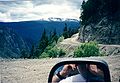 Descending Bella Coola Hill
 -
 Sheep Creek Bridge across the Chilcotin River
 -
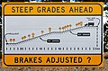 Warning sign on pullout at the top of The Hill
 -
 The LORAN-C Station near Riske Creek
 -
 Near Riske Creek
 -
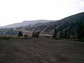
 Looking East between Kleena Kleene and Nimpo Lake
 -
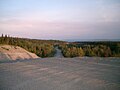
 View from the top of the Hill


References
- ^ Lee, Jeff. "Highway 20's narrow road to Bella Coola needs paving, groups say". Times Colonist. Retrieved 2019-02-23.
- ISBN 9781550171419.
- ^ "Opening of Road to Bella Coola". royalbcmuseum.bc.ca/bc-archives. Royal Museum of British Columbia. 18 July 1955. Retrieved 26 Jan 2022.
- ^ Ministry of the Provincial Secretary and Travel Industry. Film and Photographic Branch (1955). "Bella Coola Highway Plaque". royalbcmuseum.bc.ca/bc-archives. Royal Museum of British Columbia. Retrieved 26 Jan 2022.