
Burroughs Mountain
| Burroughs Mountain | |
|---|---|
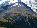
 Burroughs Mountain from east | |
| Highest point | |
| Elevation | 7,828 ft (2,386 m)[1] |
| Prominence | 388 ft (118 m)[1] |
| Coordinates | 46°54′06″N 121°42′49″W / 46.901644°N 121.713687°W |
| Naming | |
| Etymology | John Burroughs |
| Geography | |
 Burroughs Mountain Location in Washington  Burroughs Mountain Burroughs Mountain (the United States) | |
| Country | United States |
| State | Washington |
| County | Pierce |
| Protected area | Mount Rainier National Park |
| Parent range | Cascades |
| Topo map | USGS Sunrise |
| Geology | |
| Type of rock | Andesitic lava |
| Climbing | |
| Easiest route | Trail |
Burroughs Mountain is a mountain in Pierce County, Washington, United States.
Description
Burroughs Mountain is located on the northeast slope of
Burroughs Mountain is a high ridge formed from an ancient lava flow. Its three summit plateaus get progressively higher. The mountain, located within Mount Rainier National Park, is notable for alpine tundra, with plants typically seen at much higher latitudes. The tundra ground cover hugs the barren rocky plateau and has a short growing season because snow covers the ridge for much of the year in the harsh alpine climate. The unique fragile alpine tundra can be easily destroyed by people walking off the established trail.
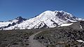
The mountain is a popular hiking destination with grand close-up views of the Emmons Glacier, Winthrop Glacier, Inter Glacier, Fryingpan Glacier, Little Tahoma Peak, and views in all directions because most of the trail is above tree line. The trail starts at the Sunrise Historic District and loops up to First Burroughs Mountain (elevation 7,160 feet) and Second Burroughs Mountain (elevation 7,402 feet). Third Burroughs Mountain (7,828 feet) is reached on an unofficial trail and is about another mile beyond Second Burroughs. The loop trail is about 6.2 miles and part of this loop trail includes a short section of the Wonderland Trail. Access is limited by snow closing the Sunrise Road much of the year, and even more by ice blocking the trail above Frozen Lake. July, August, and September are the months when the Sunrise Road is seasonally open for vehicle traffic.
Geology
Burroughs Mountain, situated at the northeast foot of Mount Rainier, WA, exposes a large-volume (3.4 km3) andesitic lava flow, up to 350 m thick and extending 11 km in length. Two sampling traverses from flow base to eroded top, over vertical sections of 245 and 300 m, show that the flow consists of a felsic lower unit (100 m thick) overlain sharply by a more mafic upper unit. The mafic upper unit is chemically zoned, becoming slightly more evolved upward; the lower unit is heterogeneous and unzoned. The lower unit is also more phenocryst-rich and locally contains inclusions of quenched basaltic andesite magma that are absent from the upper unit. Widespread, gabbronorite-to-diorite inclusions may be fragments of shallow cumulates, exhumed from the Mount Rainier magmatic system.[4]
Flora
Burroughs Mountain is renowned for its accessible variety of alpine tundra plants including sedges (Cyperaceae), Saxifraga, Dwarf lupine (Lupinus lepidus), Luetkea, Antennaria, Koenigia davisiae, Alpine yellow fleabane (Erigeron aureus), Tundra Aster (Oreostemma alpigenum), Empetrum nigrum, Arenaria lateriflora, and more.
-
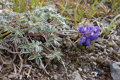 Dwarf Lupine (Lupinus lepidus)
 -
 Curved-beak lousewort (Pedicularis contorta)
 -
 Tundra Aster (Oreostemma alpigenum)
 -
 Polemonium elegans
 -
 Golden fleabane (Erigeron aureus)
 -
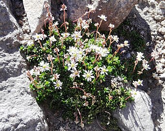 Tolmie's saxifrage (Micranthes tolmiei)
 -
 Luetkea pectinata
.jpg)
_-_Flickr_-_brewbooks_(1).jpg)
_-_Flickr_-_brewbooks.jpg)
.jpg)
_-_Flickr_-_brewbooks.jpg)
_-_Flickr_-_brewbooks.jpg)

Fauna
Burroughs Mountain is habitat for the marmot, pika, mountain goat, and chipmunk. Deer and the American black bear (Ursus americanus) can be found lower on the mountain in Berkeley Park.
Climate
Burroughs Mountain is located in the
Gallery
-
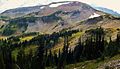 First Burroughs Mountain
 -
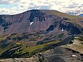 Second Burroughs Mountain (seen from Skyscraper Mountain)
 -
 Third Burroughs Mountain
 -
 Burroughs Mountain from above
 -
 Top of First Burroughs Mountain view of Rainier
 -
 Burroughs Mountain above sea of clouds
 -
 Panoramic of Mount Rainier from Second Burroughs
 -
 Second Burroughs viewed from Third Burroughs


_with_snow_looking_west._11976._slide_(a1887698d8f1453db7085e0b081cd804).jpg)


See also
References
- ^ a b "Burroughs Mountain, Washington". Peakbagger.com.
- ^ Dictionary of American Biography, II, 330- 334.
- ^ "Burroughs Mountain". Geographic Names Information System. United States Geological Survey, United States Department of the Interior. Retrieved 2024-04-02.
- ^ Origin and emplacement of the andesite of Burroughs Mountain, a zoned, large-volume lava flow at Mount Rainier, Washington, USA Journal of Volcanology and Geothermal Research By: K.R. Stockstill, T.A. Vogel, and T.W. Sisson
- ^ a b c d e Beckey, Fred W. Cascade Alpine Guide, Climbing and High Routes. Seattle, WA: Mountaineers Books, 2008.
External links
- National Park Service web site: Mount Rainier National Park
- Weather: Burroughs Mountain