
Cẩm Phả
You can help expand this article with text translated from the corresponding article in Vietnamese. (March 2009) Click [show] for important translation instructions.
|
You can help expand this article with text translated from the corresponding article in Russian. (March 2014) Click [show] for important translation instructions.
|
Cẩm Phả
Thành phố Cẩm Phả | |
|---|---|
| Cẩm Phả City | |
 | |
|
UTC+7 (UTC + 7) | |
| Climate | Cwa |
| Website | Cẩm Phả City |
Cẩm Phả ( Coal still forms the basis of Cẩm Phả's local economy, with other industries including quarrying, lime production, port, agriculture, forestry and fisheries.
The official town website claims several scenic and historical sites in Cẩm Phả, including the Cửa Ông Temple, Rều Island (Monkey Island), Thẻ Vàng Island, the Vũng Đục historical site, and Hang Hanh cave.[6]
History
In 1884, Cẩm Phả came under French administration. On 24 August 1886, Bavienpour established the coal company Công ty Pháp mỏ than Bắc Kỳ (
On 27 September 1945, during the August Revolution, workers drove the French out of Cẩm Phả. The French troops returned in November 1946, but the inhabitants fought back, destroying the coal mines, and hundreds of people were killed. The last French soldier withdrew from Cửa Ông, near the Cẩm Phả area on 22 April 1955.[8]
During the Vietnam War, American aircraft bombed Cẩm Phả several times due to its strategic importance.[9]
On 30 October 1963, Cẩm Phả, formerly in Hồng Quảng province, came under the jurisdiction of Quảng Ninh province when Hải Ninh and Hồng Quảng provinces merged.[10]
On 10 September 1981, Cẩm Phả's boundaries were redistributed. The town of Mông Dương was dissolved to form Mông Dương ward and Cẩm Hải commune. Cửa Ông town became Cửa Ông ward. Cọc 6 town and Thái Bình commune became Cẩm Phú and Cẩm Thịnh wards.[11]
On 21 February 2012, Cẩm Phả was upgraded from a town to a city.[12][13]
Administrative divisions
The city contains 13
| Danh sách các đơn vị hành chính trực thuộc thành phố Cẩm Phả[14] | ||||||||||||||||||||||||||||||||||||||||||||||||||||||||||||||
|---|---|---|---|---|---|---|---|---|---|---|---|---|---|---|---|---|---|---|---|---|---|---|---|---|---|---|---|---|---|---|---|---|---|---|---|---|---|---|---|---|---|---|---|---|---|---|---|---|---|---|---|---|---|---|---|---|---|---|---|---|---|---|
|
|
|||||||||||||||||||||||||||||||||||||||||||||||||||||||||||||
Port of Cẩm Phả
Though the port of Cẩm Phả has a general maximum draft of 4.8 metres, it has a separate coal loading terminal with a
Environment
Coal mining in Cẩm Phả started over 100 years ago. Mining area discharges to the sea about 9 million m3 waste water and 8 million m3 domestic waste water. Another issue is deforestation, for example, from 1969 to 1974, about 42% of area of forest land was reduced.[18]
Climate
| Climate data for Cẩm Phả (Cửa Ông) | |||||||||||||
|---|---|---|---|---|---|---|---|---|---|---|---|---|---|
| Month | Jan | Feb | Mar | Apr | May | Jun | Jul | Aug | Sep | Oct | Nov | Dec | Year |
| Record high °C (°F) | 28.7 (83.7) |
29.8 (85.6) |
33.5 (92.3) |
34.6 (94.3) |
36.1 (97.0) |
37.4 (99.3) |
38.8 (101.8) |
36.9 (98.4) |
36.1 (97.0) |
34.8 (94.6) |
33.0 (91.4) |
29.6 (85.3) |
38.8 (101.8) |
| Mean daily maximum °C (°F) | 18.8 (65.8) |
19.2 (66.6) |
21.9 (71.4) |
26.3 (79.3) |
30.6 (87.1) |
31.8 (89.2) |
32.1 (89.8) |
31.7 (89.1) |
30.9 (87.6) |
28.6 (83.5) |
25.2 (77.4) |
21.3 (70.3) |
26.5 (79.7) |
| Daily mean °C (°F) | 15.5 (59.9) |
16.3 (61.3) |
19.0 (66.2) |
23.0 (73.4) |
26.7 (80.1) |
28.2 (82.8) |
28.5 (83.3) |
27.8 (82.0) |
26.8 (80.2) |
24.6 (76.3) |
21.0 (69.8) |
17.3 (63.1) |
22.9 (73.2) |
| Mean daily minimum °C (°F) | 13.4 (56.1) |
14.5 (58.1) |
17.1 (62.8) |
20.9 (69.6) |
24.2 (75.6) |
25.7 (78.3) |
25.9 (78.6) |
25.2 (77.4) |
24.2 (75.6) |
21.8 (71.2) |
18.4 (65.1) |
14.8 (58.6) |
20.5 (68.9) |
| Record low °C (°F) | 3.8 (38.8) |
4.7 (40.5) |
6.0 (42.8) |
11.1 (52.0) |
16.8 (62.2) |
17.9 (64.2) |
20.9 (69.6) |
20.5 (68.9) |
16.6 (61.9) |
13.3 (55.9) |
8.2 (46.8) |
5.0 (41.0) |
3.8 (38.8) |
| Average rainfall mm (inches) | 35.0 (1.38) |
29.1 (1.15) |
50.1 (1.97) |
92.6 (3.65) |
196.5 (7.74) |
312.1 (12.29) |
414.9 (16.33) |
504.8 (19.87) |
346.7 (13.65) |
156.3 (6.15) |
56.2 (2.21) |
22.4 (0.88) |
1,935.6 (76.20) |
| Average rainy days | 8.4 | 11.4 | 14.8 | 11.8 | 12.0 | 15.3 | 16.7 | 18.6 | 13.7 | 8.9 | 6.0 | 5.8 | 143.3 |
| Average relative humidity (%)
|
81.6 | 86.0 | 87.9 | 86.8 | 83.7 | 84.5 | 84.2 | 85.7 | 82.7 | 79.0 | 77.7 | 77.2 | 83.1 |
| Mean monthly sunshine hours | 63.4 | 46.7 | 37.6 | 81.8 | 158.8 | 153.5 | 177.0 | 161.2 | 164.3 | 165.0 | 139.6 | 99.1 | 1,448 |
| Source: Vietnam Institute for Building Science and Technology[19] | |||||||||||||
Sports
The
Gallery
-
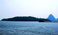 Monkey Island - Moss Island
 -


References
- ^ a b "Cẩm Phả Port Information". www.yicang.com. Yicang Port Database. Archived from the original on 2 February 2019. Retrieved 15 June 2017.
- ^ "Cẩm Phả (District-level City, Quảng Ninh, Vietnam) - Population Statistics, Charts, Map and Location". www.citypopulation.de. Retrieved 2024-02-07.
- ^ (in Vietnamese)Về việc thành lập thành phố Cẩm Phả thuộc tỉnh Quảng Ninh, Government Web Portal
- ^ T. H. Yellowdawn (2008). Fermented Foods: Naturally Enzymatic Therapy. p. 274: "Cẩm Phả is a town in Vietnam, where was the place of coal mine, the biggest coal industry in south of Asia has been exploited in almost a century, close to seashore of Ha Long Bay, where is the eighth wonderful scenery of thousand ..."
- ^ Cẩm Phả coal mine Archived 2013-11-02 at the Wayback Machine
- ^ Cẩm Phả town website Archived 2016-03-03 at the Wayback Machine 2/25/2011
- ^ MEDIATECH. "Di tích trụ sở Công ty Pháp mỏ than Bắc Kỳ". baoquangninh.com.vn (in Vietnamese). Retrieved 2022-03-22.
- ^ "Lịch sử - văn hoá - xã hội". CỔNG THÔNG TIN ĐIỆN TỬ TỈNH QUẢNG NINH (in Vietnamese). Archived from the original on 3 January 2014. Retrieved 2022-03-22.
- OCLC 774384452.
- ^ "Nghị Quyết hợp nhất tỉnh Hải Ninh và khu Hồng Quảng và sáp nhập xã Hữu Sản thuộc huyện Đình Lập, tỉnh Hải Ninh, huyện Sơn Động, tỉnh Hà Bắc". thuvienphapluat.vn. Retrieved 2022-03-22.
- ^ "Quyết định 63-HĐBT phân vạch địa giới xã, phường thị trấn tỉnh Quảng Ninh". thuvienphapluat.vn. Retrieved 2022-03-22.
- ^ "Nghị quyết 04/NQ-CP thành lập thành phố Cẩm Phả tỉnh Quảng Ninh". thuvienphapluat.vn. Retrieved 2022-03-22.
- ^ "Thành phố Cẩm Phả: Lễ kỷ niệm 10 năm ngày thành lập". campha.gov.vn (in Vietnamese). Retrieved 2022-03-22.
- ^ " Archived 2014-03-23 at the Wayback Machine, Danh sách đơn vị hành chính
- ^ "Port information - Cẩm Phả". Sea rates.
{{cite web}}: Missing or empty|url=(help) - ^ "Port of Cẩm Phả - port information". www.port.sol.com.cn. China ports directory. Retrieved 15 June 2017.
- ^ Guide to port entry - Port of Cẩm Phả - Ship Masters report. London: IHS Fairplay. 1 January 2017.
- ISBN 9789054108252.
- ^ "Vietnam Institute for Building Science and Technology" (PDF).
| Bắc Giang province |  | |
|---|---|---|
| Bắc Kạn province | ||
| Cao Bằng province | ||
| Hà Giang province | ||
| Lạng Sơn province | ||
| Phú Thọ province | ||
| Quảng Ninh province |
| |
| Thái Nguyên province | ||
| Tuyên Quang province | ||
※ denotes provincial seat. | ||
- ^ "Địa giới hành chính thành phố Cẩm Phả". Cổng thông tin điện tử Chính phủ (in Vietnamese).