Calshot
This article needs additional citations for verification. (April 2019) |
| Calshot | ||
|---|---|---|
Shire county | ||
| Region | ||
| Country | England | |
| Sovereign state | United Kingdom | |
| Post town | SOUTHAMPTON | |
| Postcode district | SO45 | |
| Dialling code | 023 | |
| Police | Hampshire and Isle of Wight | |
| Fire | Hampshire and Isle of Wight | |
| Ambulance | South Central | |
| UK Parliament | ||
Calshot is a coastal village in
History
In 1539,
Calshot is notable for its role in the development of aircraft and flying boats. In 1913 the
Relationship with Tristan da Cunha
Following a volcanic eruption in 1961, the population of the Tristan da Cunha islands was evacuated to Calshot.[3] Many evacuees thrived, with the children attending local schools and adults employed in a variety of local businesses and ships. However, problems occurred: one of the islanders' elders, a disabled gentleman called Ian Bootla, was mugged, the islanders lacked immunity from flu epidemics, and they also had to endure the harsh winter of 1962–63. Most of the islanders returned home, but some of the families decided to stay and remain a close-knit community centred on a complex of 50 houses called Tristan Close. Those that returned to Tristan da Cunha renamed the harbour there Calshot Harbour, after their temporary home.
Today


The original hangar from the
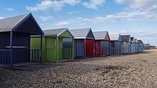
Next to the hangar is a dinghy marina. The approach road passes on the landward side of the spit, and there are a large number of beach huts.

The spit comprises a flint pebble structure around one mile long. Between it and the main shore is a salt marshy area with a wealth of wildlife and birds. The nearby
See also
References
- ISBN 9780319241509
- ^ Historic England. "Calshot Castle (1014619)". National Heritage List for England.
- ^ "Tristan da Cunha islanders remember life at Calshot". BBC News. 5 October 2011.
- ^ "Calshot Activities Centre". Visit Hampshire. Retrieved 3 April 2019.

