
Cecil Hoskins Nature Reserve
| Cecil Hoskins Nature Reserve Bowral | |
|---|---|
| Coordinates | 34°31.942′S 150°23.887′E / 34.532367°S 150.398117°E |
| Established | 7 March 1975[1] |
| Area | 0.46 km2 (0.2 sq mi)[1] |
| Managing authorities | NSW National Parks & Wildlife Service |
| Website | Cecil Hoskins Nature Reserve |
| See also | Protected areas of New South Wales |
The Cecil Hoskins Nature Reserve is a protected nature reserve located in the Southern Highlands area of New South Wales, Australia. The 46-hectare (110-acre) reserve is situated between the towns of Bowral and Moss Vale and is known for bird watching.[1]
Description
The nature reserve is a mostly cleared area with a dammed section of the Wingecarribee River. Much of the area was cleared in the 1820s by Charles Throsby. The Throsby Park Historic Site is located near the reserve. There is some remnant bushland with the rare Camden woollybutt and some of the best stands of snow gums in the southern Highlands. Recent plantings have increased the area of natural bushland.
Barbecue, picnic facilities and public toilets are present. The area is more of a cultural reserve than preserved natural bushland.[2]
Etymology
Fauna
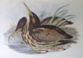
The bird life of the area is of interest. At least 90 species of birds have been recorded. Cecil Hoskins Nature Reserve is an important resting and feeding place for many migratory species, particularly waterbirds. During drought, many inland birds find refuge here. Noteworthy sightings recorded here include the blue-billed duck and the rare Australasian bittern.[2]
Gallery
-

-
-
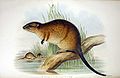 Australian water rat


See also
References
- ^ a b c "Cecil Hoskins Nature Reserve". Office of Environment & Heritage. Government of New South Wales. Retrieved 19 September 2014.
- ^ ISBN 0-7310-7676-1. Retrieved 23 September 2012.