
Western Sydney Regional Park
| Western Sydney Regional Park | |
|---|---|
NSW National Parks and Wildlife Service | |
| Operated by | Fairfield City Council |
| Status | Open all year |
Western Sydney Regional Park is a large
The park is governed by the
History
The Parkland was an area of specialty for the
Prominent early settlers such as
Geography
The regional park is bounded by
Located in the
Furthermore, two radio
Ecology

Western Sydney Regional Park features around 135 hectares of
Four vegetation zones are known within the park, which are endangered ecological communities. They are:
- Cumberland Plain Woodland: Features the Shale Plains and Shale Hills Woodland, both of which are listed as a critically endangered ecological communities in the Cumberland Plain
- River-Flat Eucalypt Forest: Found on coastal AlluvialWoodland
- Western Sydney Dry Rainforest: Found in a small pocked of the regional park, and is listed as an endangered ecological community
- Moist Shale Woodland: Also listed as an endangered ecological community
Vegetation
The main trees in the regional park's grassy woodlands include
The most widespread
The Western Sydney Dry Rainforest, which is to the west of the park, features
The Moist Shale Woodland in the park features a shrubby understorey that has plants from moist habitats. They include Eucalyptus tereticornis, E. moluccana, E. crebra and Corymbia maculata. Smaller trees, such as Acacia implexa and Acacia parramattensis ssp parramattensis are also predominant. The shrub layer includes Breynia oblongifolia, Clerodendrum tomentosum and Sigesbeckia orientalis ssp orientalis.[1] Invasive plant species include, Araujia sericifera, Cardiospermum grandiflorum, Asparagus asparagoides, Rubus ulmifolius, Cestrum parqui, Lantana camara, Olea europaea subsp. cuspidata, Ligustrum lucidum, Ligustrum sinense and Lycium ferocissimum.[1]
Wildlife
A Wildlife Atlas survey has observed and identified 167
Threatened animal species such as
Recreation

The park is particularly used for family
The park's main recreational points include Pimelea, Sugarloaf Ridge, The Dairy and Plough and Harrow picnic areas, all of which have shelters, playgrounds and free barbeques, in addition to large parking spaces. There exists a walking track called the Spotted Gum Trail, which is 3 km in length, that loops around Plough and Harrow within the native bushland, thereby allowing walkers to encounter kangaroos and wallabies, in addition to
Recreational areas and facilities include:
- Lizard Log – Features a nature themed playground for children, over 20 picnic shelters, scenic walks, a pavilion and an amphitheater.
- The Dairy – Features picnic shelters and electric barbeques on a hilltop location.
- Plough and Harrow – An area surrounded by native bushland that features a café, a playground, over 20 picnic areas, a high ropes course and an open space at the west end.
- Moonrise Lookout – A recreational lookout area that has an altitude ranging from 130 to 140 metres (430 to 460 ft) above sea level.
- Sugarloaf Ridge – Also a highly elevated lookout area, adjacent to the above place, which features two large picnic shelters.
- Calmsley Hill City Farm – An educational farm aimed for school children.
- Sydney International Equestrian Centre – A facility which was used to host equestrian events during the 2000 Summer Olympics and 2000 Summer Paralympics.
- TreeTops Adventure Park – An attraction that features high ropes on tree tops, and includes activities such as multiple zip lines and aerial challenges on the native trees.
The regional park features five walking loops, which all have trail grades:[13]
- Moonrise Loop – A challenging, 6.2km walk which features lookouts, and animals such as kangaroos and wallabies being spotted.
- Pimelea Loop – An easy 1.6km walk that links Lizard Log and The Dairy with playgrounds, lookouts and waterways.
- Sugarloaf Loop – A challenging, 2km walk that offers views of Western Sydney and the Sydney CBDskyline.
- Spotted Gums Trail – A 3km long, demanding trail that goes through spotted gum trees.
- Plough and Harrow Loop – A gentle 1.6km loop that crosses the picnic areas of the parkland.
Gallery
-
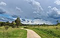
 Walking path in The Dairy
 -
 Walking path near Plough and Harrow picnic area
 -
 Lizard Log play area
 -
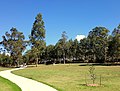
 Picnic shelters
 -
 Sugarloaf Ridge picnic area
 -
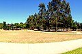
 A small savanna (grassy woodland) near Lizard Log
 -
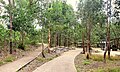
 Walking path near Lizard Log
 -
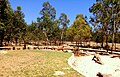
 Looking over a swamp and woody grassland


See also
References
- ^ a b c d e f g Western Sydney Regional Park Draft Plan of Management 2010 NSW National Parks and Wildlife Service Part of the Department of Environment, Climate Change and Water
- ISBN 978-0-646-91896-9
- ^ a b Western Sydney Regional Park National Parks and Wildlife Service. KI Studio. Retrieved 31 August 2022.
- ^ a b c d e "Archived copy". Archived from the original on 21 April 2013. Retrieved 15 November 2013.
{{cite web}}: CS1 maint: archived copy as title (link) - ^ "Archived copy". Archived from the original on 21 April 2013. Retrieved 15 September 2013.
{{cite web}}: CS1 maint: archived copy as title (link) - ^ RTA (2008) The Western Sydney Regional Aboriginal Heritage Study. NSW Department of Environment and Climate Change
- ^ HASSELL (2010b) Draft Western Sydney Parklands Plan of Management 2010–2020.
- ^ URS (2004) Western Sydney Regional Parklands, Management Vision and Concept Plan Options, Department of Infrastructure, Planning and Natural Resources.
- ^ NSW NPWS (2006) Western Sydney Regional Park Statement of Interim Management Intent. NSW National Parks and Wildlife Service, Cumberland South.
- ^ NSW NPWS (2002) Native Vegetation of the Cumberland Plain - Final Edition. NPWS, Sydney.
- ^ DECC (2006) A Vertebrate Fauna Survey of Western Sydney Regional Park. Unpublished report. NPWS, Parramatta.
- ^ Spotted Gums Loop Western Sydney Parklands
- ^ DIGITAL MAPS Western Sydney Parklands. Retrieved August 5 2023.