
Chair Peak (Washington)
| Chair Peak | |
|---|---|
 Chair Peak southeast aspect | |
| Highest point | |
| Elevation | 6,238 ft (1,901 m)[1] |
| Prominence | 878 ft (268 m)[1] |
| Parent peak | Kaleetan Peak (6,259 ft) |
| Isolation | 0.57 mi (0.92 km)[2] |
| Coordinates | 47°27′35″N 121°28′01″W / 47.459786°N 121.46686°W[1] |
| Geography | |
 Chair Peak Location in Washington  Chair Peak Location in the United States | |
| Country | United States |
| State | Washington |
| County | King |
| Protected area | Alpine Lakes Wilderness[2] |
| Parent range | Cascade Range |
| Topo map | USGS Snoqualmie Pass |
| Climbing | |
| First ascent | 1913, Hec V. Abel and L.F. Curtis[3] |
| Easiest route | Scrambling |
Chair Peak is a 6,238 ft (1,900 m) mountain summit located in east
Climate
Chair Peak is located in the
Geology
The Alpine Lakes Wilderness features some of the most rugged topography in the
The history of the formation of the Cascade Mountains dates back millions of years ago to the late
During the Pleistocene period dating back over two million years ago, glaciation advancing and retreating repeatedly scoured the landscape leaving deposits of rock debris.[5] The last glacial retreat in the Alpine Lakes area began about 14,000 years ago and was north of the Canada–US border by 10,000 years ago.[5] The U-shaped cross section of the river valleys is a result of that recent glaciation. Uplift and faulting in combination with glaciation have been the dominant processes which have created the tall peaks and deep valleys of the Alpine Lakes Wilderness area.
Gallery
-
 South aspect from Granite Mtn
 -
 Chair Peak from Kendall Peak
 -
 Chair Peak seen from Bandera Mountain
 -
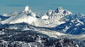 Kaleetan Peak (left) and Chair Peak (right) viewed from Noble Knob.


See also
- List of peaks of the Alpine Lakes Wilderness
- Geography of Washington (state)
- Geology of the Pacific Northwest
References
- ^ a b c d e "Chair Peak, Washington". Peakbagger.com.
- ^ a b "Chair Peak - 6,238' WA". listsofjohn.com. Retrieved 2020-08-03.
- ^ a b c d Beckey, Fred W. Cascade Alpine Guide, Climbing and High Routes. Seattle, WA: Mountaineers Books, 2008.
- ^ Smoot, Jeff (2004). Backpacking Washington's Alpine Lakes Wilderness. Helena, Montana: The Globe Pequot Press.
- ^ a b c d e Kruckeberg, Arthur (1991). The Natural History of Puget Sound Country. University of Washington Press.
External links
- Weather forecast: Chair Peak
- Alpine Lakes Wilderness (Mt. Baker-Snoqualmie National Forest) U.S. Forest Service