Cup and Saucer Creek
| Cup and Saucer Creek | |
|---|---|
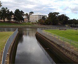
 Cup and Saucer Creek, at its confluence with the Cooks River. | |
| Location | |
| Country | Australia |
| State | New South Wales |
| IBRA | Sydney Basin, Canterbury-Bankstown |
| District | Southern Sydney |
| Municipality | Canterbury |
| Physical characteristics | |
| Source | |
| • location | near Wiley Park railway station |
Earlwood | |
| Length | 4 km (2.5 mi) |
| [1] | |
Cup and Saucer Creek, an urban watercourse of the Cooks River catchment, is located in the Canterbury-Bankstown region of Sydney, in New South Wales, Australia.
Course and features

Cup and Saucer Creek rises in
organochlorines.[2]
The creek is so named because of sandstone formations in the former bed of the creek.[3]
A concrete
NSW State Heritage Register.[3]
References
- ^ "Cup and Saucer Creek". Geographical Names Register (GNR) of NSW. Geographical Names Board of New South Wales. Retrieved 9 April 2013.
- ^ "Existing Catchment Conditions: Cup and Saucer Creek" (PDF). Cooks River Stormwater Management Plan. Canterbury City Council. 1999. p. 46. Archived from the original (PDF) on 26 March 2012. Retrieved 9 April 2013.
- ^ a b "Cup and Saucer Creek Culvert". Office of Environment & Heritage. 29 October 2004. Retrieved 23 March 2022.
