
Econlockhatchee River
| Econlockhatchee River Econ River | |
|---|---|
 Econlockhatchee River from the Florida Trail bridge | |
| Etymology | "Rivers of mounds" |
| Location | |
| Country | United States |
| Location | Central Florida |
| Physical characteristics | |
| Source | |
| • location | Lake Conlin north of Holopaw |
| • coordinates | 28°14′29″N 81°6′31″W / 28.24139°N 81.10861°W |
| • elevation | 92 feet (28 m)[1] |
Turkey Creek, Little Econlockhatchee River | |
The Econlockhatchee River (Econ River for short) is an 54.5-mile-long (87.7 km)Outstanding Florida Waters.[3]
The origin of the river's name is not known definitively. In 1839 the spelling was recorded as “Econ-like Hatchee”. It is theorized that this represents a Muscogee name meaning “earth-mound stream”, with “econ-like” coming from ēkvnv (/iːkaná/), ‘earth, land’, and like (/léyki/), ‘sitting’, plus hvcce (/háčči/), ‘stream’.[5]
The river flows north from its
source, Lake Conlin, through the Econlockhatchee River Swamp (see below) south of State Road 528. Near the City of Oviedo, the tributary Little Econlockhatchee River joins, and the river turns east as it flows through the Little Big Econ State Forest. The Econlockhatchee joins the St. Johns River near Puzzle Lake. The river's floodplain is forested
for its entire length.
Econlockhatchee River Swamp
The upper course of the river is called the Econlockhatchee River Swamp. Located southeast of
Turkey Creek flows. North of Wewahootee Road, the Econlockhatchee River leaves the swamp and remains a free-flowing river for the rest of its journey to the St. Johns River
.
List of crossings
Gallery
River views


Fauna
-
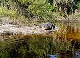
 Youngalligatorsalong the river bank
 -
 AFlorida cootersunning on top of a log
 -


.jpg)
See also
- List of Florida rivers
- Hal Scott Preserve
- Oviedo, Florida
- Wedgefield, Florida formerly known as "Rocket City"
References
- ^ "Holopaw Topo Map at Lat 28.243°N Long -81.1076°W Zoom 15 S Size". Trails.com. Retrieved on 2014-08-04.
- ^ "Geneva Topo Map at Lat 28.7035°N Long -81.028°W Zoom 15 S Size". Trails.com. Retrieved on 2014-08-04.
- ^ a b (2013-01-02). "Econlockhatchee River". Saint Johns River Water Management District. Retrieved on 2014-08-04.
- ^ U.S. Geological Survey. National Hydrography Dataset high-resolution flowline data. The National Map Archived 2012-03-29 at the Wayback Machine, accessed April 21, 2011
- ISBN 978-0-8061-3598-4.
External links
Wikimedia Commons has media related to Econlockhatchee River.
- Econlockhatchee River Paddling Trail maps and information from the Florida Department of Environmental Protection