
St. Johns River
| St. Johns River | |
|---|---|
 St. Johns River near Astor | |
 St. Johns River surrounding with corresponding watersheds designated by the St. Johns River Water Management District: 1. Upper basin, 2. Middle basin, 3. Lake George basin, 4. Lower basin, 5. Ocklawaha River basin | |
| Etymology | Spanish: San Juan del Puerto |
| Location | |
| Country | United States |
| State | Florida |
| Cities | Sanford, DeBary, Deltona, DeLand, Palatka, Green Cove Springs, Orange Park, Jacksonville |
| Physical characteristics | |
| Source | St. Johns Marsh |
| • location | near Vero Beach, Indian River County, Florida |
| • coordinates | 27°57′18″N 80°47′3″W / 27.95500°N 80.78417°W[1] |
| • elevation | 30 ft (9.1 m) |
Mayport, Florida | |
| • average | 15,000 cu ft/s (420 m3/s) |
| • maximum | 150,000 cu ft/s (4,200 m3/s) |
| Basin features | |
| Tributaries | |
| • left | Mills Creek River, Econlockhatchee River, Wekiva River, Alexander Springs, Salt Springs Run, Ocklawaha River, Rice Creek, Simms Creek, Black Creek, Ortega River, Trout River |
| • right | Murphy Creek/Dunn's Creek, Julington Creek, Pottsburg Creek, Intracoastal Waterway/Sisters Creek |
The St. Johns River (Spanish: Río San Juan) is the longest river in the U.S. state of Florida and it is the most significant one for commercial and recreational use.[note 1] At 310 miles (500 km) long, it flows north and winds through or borders twelve counties. The drop in elevation from headwaters to mouth is less than 30 feet (9 m); like most Florida waterways, the St. Johns has a very slow flow speed of 0.3 mph (0.13 m/s), and is often described as "lazy".[2]
Numerous lakes are formed by the river or flow into it, but as a river its widest point is nearly 3 miles (5 km) across. The narrowest point is in the headwaters, an unnavigable marsh in
Although Florida was the location of the first permanent European settlement in what would become the United States, much of Florida remained an undeveloped frontier into the 20th century. With the growth of population, the St. Johns, like many Florida rivers, was altered to make way for agricultural and residential centers, suffering severe pollution and redirection that has diminished its
Historically, a variety of people have lived on or near the St. Johns, including
Geography and ecology
Starting in Brevard County and meeting the Atlantic Ocean at Duval County, the St. Johns is Florida's primary commercial and recreational waterway. It flows north from its headwaters, originating in the direction of the Lake Wales Ridge, which is only slightly elevated at 30 feet (9.1 m) above sea level. Because of this low elevation drop, the river has a long backwater. It ebbs and flows with tides that pass through the barrier islands and up the channel.[7] Uniquely, it shares the same regional terrain as the parallel Kissimmee River, although the Kissimmee flows south.[2]
Upper basin
The St. Johns River is separated into three basins and two associated watersheds managed by the St. Johns River Water Management District. Because the river flows in a northerly direction, the upper basin is located in the headwaters of the river at its southernmost point.[8][note 1] Indian River County is where the river begins as a network of marshes, at a point west of Vero Beach aptly named the St. Johns Marsh in central Florida. The St. Johns River is a blackwater stream, meaning that it is fed primarily by swamps and marshes lying beneath it; water seeps through the sandy soil and collects in a slight valley.[9] The upper basin measures approximately 2,000 square miles (5,200 km2); the St. Johns transforms into a navigable waterway in Brevard County. The river touches on the borders of Osceola and Orange Counties, and flows through the southeast tip of Seminole County, transitioning into its middle basin a dozen miles (19 km) or so north of Titusville.[8]
The upper basin of the St. Johns was significantly lowered in the 1920s with the establishment of the Melbourne Tillman drainage project. This drained the St. Johns' headwaters eastward to the Indian River through canals dug across the Ten-Mile Ridge near Palm Bay. As of 2015, these past diversions are being partially reversed through the first phase of the Canal 1 Rediversion project.[10]
The river is at its narrowest and most unpredictable in this basin. Channel flows are not apparent and are usually unmarked. The most efficient way to travel on this part of the river is by

Wetlands in the upper and middle basin are fed by rainwater, trapped by the structure of the surrounding land. It is an oxygen- and nutrient-poor environment; what grows usually does so in peat which is created by centuries of decaying plant material.[16] Water levels fluctuate with the subtropical wet and dry seasons. Rain in central and north Florida occurs seasonally during summer and winter, but farther south rain in winter is rare.[17] All plants in these basins must tolerate water fluctuation, both flooding and drought. Sweetbay (Magnolia virginiana), cypress (Taxodium), and swamp tupelo (Nyssa biflora) trees often find great success in this region on raised land called hammocks.[16] Trees that live in water for long periods usually have buttressed trunks, tangled, braided roots, or protrusions like cypress knees to obtain oxygen when under water, but the majority of plant life is aquatic. Wetland staples include the American white waterlily (Nymphaea odorata), pitcher plants, and Virginia iris (Iris virginica). In the southernmost points of the river, Cladium, or sawgrass, grows in vast swaths of wet prairie that at one time extended into the Everglades.[18] These wetland flora are remarkably successful in filtering pollutants that otherwise find their way into the river.[19]
Middle basin

For 37 miles (60 km) the river passes through a 1,200-square-mile (3,100 km2) basin fed primarily by springs and stormwater runoff. This basin, spreading throughout Orange,
Optimally an 8-foot (2.4 m) deep channel about 100 yards (91 m) wide after leaving Lake Monroe, the St. Johns meets its most significant

Of most vital importance to marshes are invertebrate animals, the foundation of
Of vertebrates, numerous species of frog, salamander, snake, turtle, and alligator (
- Birds found in the middle and upper St. Johns River basins
-
 American white ibis (Eudocimus albus)
 -
 Barred owl (Strix varia)
 -
 Wood stork (Mycteria americana)
 -
 Limpkin (Aramus guarauna)
 -
 American black vulture (Coragyps atratus)
 -
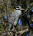 Yellow-crowned night heron (N. violacea)
 -
 Red-shouldered hawk (Buteo lineatus)
 -
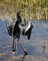 Anhinga (Anhinga anhinga)


Lake George

The river turns north again as it rolls through a 46,000-acre (190 km2) basin spreading across
Bordering to the north of Blue Spring State Park is

The St. Johns creeps into the southern tip of
Ocklawaha River
The Ocklawaha River flows north and joins the St. Johns as the largest tributary, and one of significant historical importance. The Ocklawaha (also printed as Oklawaha) drainage basin expands through Orange, Lake, Marion, and Alachua Counties, comprising a total of 2,769 square miles (7,170 km2). Ocala, Gainesville, and the northern suburbs of the Orlando metropolitan area are included in this basin. There are two headwaters for the Ocklawaha: a chain of lakes, the largest of which is Lake Apopka in Lake County, and the Green Swamp near Haines City in Polk County, drained by the Palatlakaha River. The Silver River, fed by one of Florida's most productive springs expelling 54,000,000 US gallons (200,000,000 L) daily, is located about midway along the 96-mile (154 km) Ocklawaha.[44]
Confederate Captain John William Pearson named his militia after the Ocklawaha River called the Ocklawaha Rangers in the American Civil War.[45] Prior to the civil war, Pearson ran a successful health resort in Orange Springs. After the civil war Pearson's Orange Springs resort declined in popularity due to the increasing attention to nearby Silver Springs—the source of the Silver River—at the turn of the 20th century, popularizing the Ocklawaha. Georgia-born poet Sidney Lanier called it "the sweetest waterlane in the world" in a travel guide he published in 1876.[46][47] The river gave Marjorie Kinnan Rawlings access to the St. Johns from her homestead at Orange Lake. The region served as a major fishing attraction until a decline in water quality occurred in the 1940s,[48] and since then further degradation of the river and its sources have occurred. In particular, Lake Apopka earned the designation of Florida's most polluted lake following a chemical spill in 1980 that dumped DDE in it.[49] It has experienced chronic algal blooms caused by citrus farm fertilizer and wastewater runoff from nearby farms.[50]
The proliferation of largemouth bass (
Lower basin
From the intersection of the Ocklawaha River, 101 miles (163 km) to the Atlantic Ocean, the St. Johns lies within the lower basin, draining a total area of 2,600 square miles (6,700 km2) in Putnam, St. Johns, Clay, and Duval Counties. Twelve tributaries empty into the river in the lower basin. The St. Johns River widens considerably on the north end of Lake George; between Lake George and Palatka the river ranges between 600 and 2,640 feet (180 and 800 m) wide. Between Palatka and Jacksonville, that widens further to between 1 and 3 miles (1.6 and 4.8 km). This portion of the river is the most navigable and shipping is its primary use. The Army Corps of Engineers maintains shipping channels at least 12 feet (3.7 m) deep and 100 feet (30 m) wide. North of Jacksonville, the channels are expanded to 40 feet (12 m) deep and between 400 and 900 feet (120 and 270 m) wide.[54]

The towns and cities along the lower basin of the river are some of the oldest in Florida, and their histories have centered on the river. Both Palatka and Green Cove Springs have been popular tourist destinations in the past. Several smaller locations along the river sprang up around ferry landings, but when rail lines and then Interstate highways were constructed closer to the Atlantic Coast, many of the towns experienced significant economic decline, and ferry landings were forgotten.[55]
The final 35 miles (56 km) of the river's course runs through Jacksonville with a population of more than a million. Much of the economic base of Jacksonville depends on the river: 18,000,000 short tons (16,000,000 t) of goods are shipped in and out of Jacksonville annually. Exports include paper, phosphate, fertilizers, and citrus, while major imports include oil, coffee, limestone, cars, and lumber.
If I could have, to hold forever, one brief place and time of beauty, I think I might choose the night on that high lonely bank above the St. Johns River —Marjorie Kinnan Rawlings in Cross Creek
Using an unofficial nickname of "The River City", Jacksonville has a culture centered on the St. Johns. An annual footrace named the
Tides cause seawater to enter the mouth of the St. Johns River and can affect the river's level into the middle basin. As a result, much of the river in Jacksonville is part seawater, making it an
Although freshwater invertebrates inhabiting and comprising algae and periphyton make the foundation of food webs in the middle and lower basin,

Formation and hydrology

Geologic history
Lying within a
From its origins to approximately the area of Sanford, the St. Johns flows north.
Springs and aquifers

All of Florida's abundant fresh water is the result of precipitation that returns to the atmosphere in a process called
Acidic rainwater erodes the limestone and can form caverns. When the overlay of these caverns is particularly thin—less than 100 feet (30 m)—sinkholes can form. Where the limestone or sand/clay overlay dissolves over the aquifer and the pressure of the water pushes out, springs form. The upper and middle basins of the St. Johns River are located in a portion of the peninsula where the aquifer system is thinly confined, meaning springs and sinkholes are abundant. Springs are measured in magnitude of how much water is discharged, which is dependent upon season and rainfall. The greatest discharge is from first magnitude springs that emit at least 100 cubic feet (2.8 m3) of water per second. There are four first magnitude springs that feed the St. Johns River: Silver Springs in Marion County, emitting between 250 and 1,290 cubic feet (7.1 and 36.5 m3)/second;[71] Silver Glen Spring straddling Marion and Lake Counties, emitting between 38 and 245 cubic feet (1.1 and 6.9 m3)/second;[72] Alexander Springs in Lake County, emitting between 56 and 202 cubic feet (1.6 and 5.7 m3)/second;[73] and Blue Spring in Volusia County, emitting between 87 and 218 cubic feet (2.5 and 6.2 m3)/second.[74][75]
Rainfall and climate

The St. Johns River lies within a
Rain occurs more frequently in late summer and early fall.
Graphs are unavailable due to technical issues. There is more info on Phabricator and on MediaWiki.org. |
Flow rates and water quality

The entire river lies within the nearly flat Pamlico terrace, giving it an overall gradient of 0.8 inches (2.0 cm) per mile (km); it is one of the flattest major rivers on the continent.[11] Its proximity to the ocean in the lower basin affects its rise and fall with tides and salinity. Tides regularly affect water levels as far south as Lake George; when combined with extreme winds, the river's tidal effects can extend to Lake Monroe 161 miles (259 km) away and have on occasion reached Lake Harney.[56] Tides typically raise the river level about 1.2 feet (0.37 m) at Jacksonville, decreasing some to 0.7 feet (0.21 m) at Orange Park where the river widens, and increasing back to 1.2 feet (0.37 m) at Palatka as it narrows. As a result of tidal effects, discharge measurements in the lower basin are often inaccurate. However, the estimated rate of discharge between the Ocklawaha River and the center of Jacksonville ranges from 4,000 to 8,300 cubic feet (110 to 240 m3) per second.[54] The nontidal discharge at the mouth at Mayport averages 15,000 cubic feet (420 m3) per second, but with tides it exceeds 50,000 cubic feet (1,400 m3) per second, and following heavy rains combined with tides can top 150,000 cubic feet (4,200 m3) per second.[56] Farther upriver, the discharge rate ranges from 1,030 cubic feet (29 m3) per second near Lake Poinsett to 2,850 cubic feet (81 m3) per second near DeLand. The confluence of numerous springs, the Econlockhatchee River, and the Wekiva River causes the average discharge to increase by 940 cubic feet (27 m3) per second between Lake Harney and DeLand, representing the greatest annual average increase of streamflow along the St. Johns.[76]
As distance between the mouth of the St. Johns and the middle and upper basins increases, the salinity in the river gradually decreases. Marine water measures at 35 parts per thousand (ppt) or more while fresh water measures below 2 ppt. What ranges in between is characterized as brackish water. Near the center of Jacksonville, average measures have been collected at 11.40 ppt. Farther south at the Buckman Bridge, joining the south side of Jacksonville to Orange Park, it decreases to 2.9 ppt and falls again to 0.81 ppt at the Shands Bridge near Green Cove Springs.[83][84]
Like all blackwater streams in Florida, the color of most of the St. Johns is black,
Human history
Pre-Columbian people
Humans arrived on the Florida Peninsula about 12,000 years ago when the ocean was about 350 feet (110 m) lower than today, and the peninsula was double its current size.
Around 9,000 years ago, the climate warmed, melting much of the polar ice caps and many glaciers, creating a wetter environment and submerging half the peninsular shelf. As Paleo-Indians now did not have to travel as far to find water, their camps became more permanent, turning into villages. With evidence of a wide variety of tools constructed around this time, archeologists note the transition into
The advent of regional types of pottery and stone tools made of flint or limestone marked further advancements around 500
Colonial era

Though the first European contact in Florida came in 1513 when Juan Ponce de León arrived near Cape Canaveral, not until 1562 did Europeans settle the north Atlantic coast of the peninsula. Early Spanish explorers named the river Rio de Corientes (River of Currents).[29] The St. Johns River became the first place colonized in the region and its first battleground: when French explorer Jean Ribault erected a monument south of the river's mouth to make the French presence known, it alarmed the Spanish who had been exploring the southern and western coast of the peninsula for decades.[97][98] Ribault was detained after he returned to Europe.
In 1564,
The French and Spanish continued to spar over who would control the natural resources and native peoples of the territory. The Timucua, who had initially befriended the French, were not encouraged to make the Spanish allies because of colonial governor
Over a hundred years later, missionaries had more success, setting up posts along the river. Spanish Franciscan missionaries gave the river its current name based on
The Timucua, as other groups of indigenous people in Florida, began to lose cohesion and numbers by the 18th century.

After Florida came under the
In 1795, Florida was transferred back to Spain which lured Americans with cheap land. A former loyalist to Britain who left
Territorial Florida and statehood

The first years following Florida's annexation to the United States in 1821 were marked with violent conflicts between white settlers and Seminoles, whose bands often included runaway African slaves. The clashes between American and Seminole forces during the establishment of the
Although the Spanish had colonized Florida for two centuries, the state remained the last part of the east coast of the United States to be developed and explored.
A
One unforeseen aspect of more people coming to Florida proved to be an overwhelming problem.
Land boom

An Englishman named
Marjorie Kinnan Rawlings used the St. Johns as a backdrop in her books South Moon Under and The Yearling, and several short stories. In 1933 she took a boat trip along the St. Johns with a friend. In the upper basin, she remarked on the difficulty of determining direction due to the river's ambiguous flow, and wrote in a chapter titled "Hyacinth Drift" in her memoir Cross Creek that she had the best luck in watching the way the hyacinths floated.[134] Rawlings wrote, "If I could have, to hold forever, one brief place and time of beauty, I think I might choose the night on that high lonely bank above the St. Johns River."[135][note 4]
Florida in the 20th century experienced a massive migration into the state. Undeveloped land sold well and draining to reclaim wetlands has often gone unchecked, and often encouraged by government. The St. Johns headwaters decreased in size from 30 square miles (78 km2) to one between 1900 and 1972.[136] Much of the land was reclaimed for urban use, but agricultural needs took their toll as fertilizers and runoff from cattle ranching washed into the St. Johns. Without wetlands to filter the pollutants, the chemicals stayed in the river and flushed into the Atlantic Ocean. Boaters destroyed the floating islands of muck and weeds in the upper basin with dynamite, causing the lakes to drain completely.[137]
What could have been the most serious human impact on nature in central Florida was the
A separate canal, the St. Johns-Indian River Barge Canal, was planned to link the river with the Intracoastal Waterway;[141] the project never broke ground, and was canceled soon after the Cross Florida Barge Canal was suspended.[142]
Restoration

When steamboats were superseded by the railroad, the river lost much of its significance to the state. The influx of immigrants to Florida settled primarily south of Orlando, adversely affecting the natural order of wetlands there.[143] Within the past 50 years, however, urban areas in the northern and central parts of the state have grown considerably. In the upper basin, population increased by 700 percent between 1950 and 2000, and is expected to rise another 1.5 million by 2020.[144]
The State of Florida implemented a program named Surface Water Improvement and Management (SWIM) in 1987 to assist with river cleanups, particularly with
To assist with river cleanup and the associated funds for improving water quality in the St. Johns, Mayor
The continuing increase of population in Florida has caused urban planners to forecast that the
The St. Johns River is under consideration as an additional water source to meet growing public water needs. In 2008, the river's Water Management District undertook a Water Supply Impact Study of the proposed water withdrawals and asked the National Research Council to review science aspects of the study as it progressed. This resulted in a series of four reports that assessed the impact of water withdrawal on river level and flow, reviewed potential impacts on wetland ecosystems, and presented overall perspectives on the Water Management District study.[158] The National Research Council found that, overall, the District performed a competent job in relating predicted environmental responses, including their magnitude and general degree of uncertainty, to the proposed range of water withdrawals. However, the report noted that the District's final report should acknowledge such critical issues as include future sea-level rises, population growth, and urban development. Although the District predicted that changes in water management would increase water levels and flows that exceed the proposed surface water withdrawals, these predictions have high uncertainties.[159]
The report also noted concerns about the District's conclusion that the water withdrawals will have few deleterious ecological effects. This conclusion was based on the model findings that increased flows from upper basin projects and from changes in land use (increases in impervious areas) largely compensated for the impacts of water withdrawals on water flows and levels. Although the upper basin projects are positive insofar as they will return land to the basin (and water to the river), the same cannot be said about increased urban runoff, the poor quality of which is well known.[159]
See also
- List of lakes of the St. Johns River
- List of crossings of the St. Johns River
- List of Florida rivers
- List of rivers of the Americas by coastline
- South Atlantic-Gulf Water Resource Region
Notes
- ^ a b The St. Johns is frequently cited as being a rare north-flowing river in North America (Benke & Chusing, p. 100; Randazzo, p. 12), though most rivers in Canada and in parts of the United States drain north (Verdin, K. L. (March 19, 2010). "A System for Topologically Coding Global Drainage Basins and Stream Networks" Archived January 16, 2010, at the Wayback Machine, ESRI; Gonzalez, M. A. (2003). "Continental Divides in North Dakota and North America", North Dakota Geological Survey Newsletter 30 (1), pp. 1–7; Kamiar, M. (April 27, 2013). "Due North: The St. John's River is One of Many". Metro Jacksonville.).
- ^ In 1717, some of the groups were reorganized by the colonial governor; 248 Timucua were counted. The restructuring also included Yamasee, Mocama, Apalachee, and Guale: in total no more than 1,500 Indians remained in north Florida. Disease and violent conflicts with the Spanish and other tribes continued to decrease their numbers, and by 1763, 100 of the last remaining indigenous people of Florida chose to be relocated to Cuba with the Spanish. (Gannon, p. 94.)
- ^ Lake Monroe on the St. Johns was named for President James Monroe, who persuaded the U.S. government to finance the First Seminole War. As American settlers trickled in to farms and homesteads in north and central Florida, they came into increased conflict with several Seminole bands for food and sometimes took the Seminoles as slaves. The Treaty of Moultrie Creek in 1823 placed Seminoles on a reservation near Lake Okeechobee, but further U.S. policy strongly encouraged them to leave Florida for Indian Territory in what would become Oklahoma. (Tebeau, p. 156.) by 1835, the Seminoles rebelled, inspired and led by Osceola, whose name is one of the most widely used for landmarks and structures in the state. (McCarthy, p. 17.) Lake Jesup's namesake is the American military leader in Florida, Major General Thomas Jesup, who captured Osceola in 1837. Lake Harney was named for Brigadier General William S. Harney, who led several raids against Seminoles in west and south Florida. (McCarthy, p. 12.)
- ^ When Rawlings and her friend stopped in Sanford to purchase gasoline, a yacht owner offered to have his crew take her to town to buy it, but he was interrupted when his wife, resplendent in a "pink spectator sports costume", demanded he take her to church instead. As Rawlings left the dock at Sanford, her friend remarked, "The poor b—. I bet he'd give his silk shirt to go down the river with us instead of Pink Petticoats". (Rawlings, p. 366.)
- ^ Author and University of Florida professor Kevin McCarthy characterized the Cross Florida Barge Canal as "probably the single most dangerous threat to the water resources of the state in the twentieth century". (McCarthy, p. 76.)
Citations
- ^ a b c Feature Detail Report for: St. Johns River, US Geological Survey (October 19, 1979). Retrieved on October 25, 2009.
- ^ a b Whitney, p. 215.
- ^ The St. Johns River: Nominated as an American Heritage River Archived February 1, 2006, at the Wayback Machine, Environmental Protection Agency. Retrieved on July 17, 2009.
- ^ Whitney, p. 136.
- ^ a b Ball, David (April 14, 2008).St. Johns River Makes 'Endangered' List, Jacksonville Financial and Daily Record, Retrieved on July 17, 2009.
- ^ Belleville, p. xxi.
- ^ McCarthy, p. 2.
- ^ a b "Fact Sheet: A Story of the St. Johns River: The Big Picture", St. Johns River Water Management District (May 3, 2007).
- ^ Whitney, p. 216.
- ^ "District, partners celebrate restoration of historic water flows". Floridaswater.com. Palatka: St. Johns River Water Management District. November 13, 2015. Archived from the original on January 9, 2016.
For decades, Canal 1 in Palm Bay shunted storm water east to the lagoon, but recent upgrades in pumps now send up to 39 percent of the average annual storm water to Sawgrass Lake where it is naturally filtered before flowing to the St. Johns River.
- ^ a b c Benke and Cushing, p. 100.
- ^ Belleville, p. 14.
- ^ Cabell, p. 10.
- ^ McCarthy, pp. 5–6.
- ^ McCarthy, pp. 10–11.
- ^ a b Whitney, pp. 128–130.
- ^ Whitney, p. 156.
- ^ Belleville, pp. 11–12.
- ^ Whitney, pp. 132–133.
- ^ The Middle St. Johns River Basin[permanent dead link] St. Johns River Water Management District Projects in Central Florida, St. Johns River Water Management District (February 2009).
- ^ a b McCarthy, p. 20.
- ^ McCarthy, p. 22.
- ^ Cabell, pp. 11–12.
- ^ McCarthy, p. 26.
- ^ Hamaker, Elaine (January 6, 1989). "Silver Springs' Monkey Colony Will Remain", The Ocala Star-Banner, p. 2B.
- ^ Belleville, pp. 71–72.
- ^ Whitney, p. 158.
- ^ a b Whitney, p. 159.
- ^ a b c d The St. Johns River: Nominated as an American Heritage River Archived February 1, 2006, at the Wayback Machine, Environmental Protection Agency (Part 2). Retrieved on July 17, 2009.
- ^ Whitney, p. 160.
- ^ McCarthy, p. 28.
- ^ Florida Manatee Management Plan Florida Fish and Wildlife Conservation Commission (December 2007).
- ^ Blue Spring State Park, Florida Division of Recreation and Parks (2008). Retrieved on July 9, 2009.
- ^ Belleville, p. 89.
- ^ ""Episode 05 Hontoon Owl Totem" by Robert Cassanello and Chip Ford". stars.library.ucf.edu. Retrieved January 9, 2016.
- ^ River Otter, Florida Wildlife Commission. Retrieved on July 22, 2009.
- ^ River Otters Archived October 27, 2007, at the Wayback Machine, St. Johns River Water Management District (March 2004). Retrieved on July 22, 2009.
- ^ McCarthy, p. 56.
- U.S. Forest Service. Retrieved on July 9, 2009.
- ^ Whitney, p. 68.
- ^ Lake George State Forest, Florida Department of Agriculture and Consumer Services, Division of Forestry (2004). Retrieved on July 9, 2009.
- ^ McCarthy, p. 58.
- ^ Whitney, pp. 55–65.
- ^ Learn About Your Watershed: Ocklawaha River Watershed Archived June 8, 2009, at the Wayback Machine, Florida's Water: Ours to Protect, Florida Department of Environmental Protection (2009). Retrieved on July 19, 2009.
- ^ Gary, Loderhose (2000). Way Down the Suwannee River: Sketches of Florida During the Civil War. Authors Choice Press. p. 13.
- ^ Noll and Tegeder, p. 12.
- ^ Cabell, p. 15.
- ^ Kelley, Katie (October 1, 2015). "Episode 26 Fishing Boats". A History of Central Florida Podcast. Retrieved January 27, 2016.
- ^ Marino, G. (August 13, 1994). "Lake Apopka Pollution Hurts Bass Population", Science News, 146 (7), p. 102.
- ^ a b Lake Apopka Archived October 28, 2007, at the Wayback Machine, St. Johns River Water Management District (April 2008). Retrieved on July 19, 2009.
- ^ Whitney, p. 225.
- ^ Belleville, pp. 36–37.
- ^ Belleville, pp. 92–93.
- ^ a b c Spechler, R.M. Estimated discharge and chemical-constituent loading from the upper Floridan aquifer to the lower St. Johns River, northeastern Florida, 1990–91, U.S. Geological Survey, pp. i–32.
- ^ McCarthy, pp. 88–100.
- ^ a b c d Bourgerie, Richard. Currents in the St. Johns River, Florida, spring and summer of 1998, U.S. Department of Commerce, National Oceanic and Atmospheric Administration (1999), pp. i–57.
- ^ "Gate River Run" Event website. Retrieved on July 17, 2009.
- ^ "Greater Jacksonville Kingfishing Tournament" and Tournament rules Archived October 2, 2011, at the Wayback Machine Event website. Retrieved on July 17, 2009.
- ^ Young, pp. 65–71.
- ^ Whitney, pp. 303–304.
- ^ Whitney, p. 310.
- ^ Whitney, pp. 313–319.
- ^ Van Hooser, Liz (July 31, 2009). What Makes a Shrimp a Mayport Shrimp? Archived March 16, 2010, at the Wayback Machine, The Florida Times-Union. Retrieved on August 6, 2009.
- ^ Randazzo and Jones, pp. 13–25.
- ^ Randazzo and Jones, pp. 1–3.
- ^ Randazzo and Jones, p. 4.
- ^ a b Randazzo and Jones, p. 12.
- ^ Randazzo and Jones, p. 217.
- ^ Randazzo and Jones, p. 69.
- ^ Randazzo and Jones, p. 82.
- ^ Marion County: Silver Springs Archived March 15, 2009, at the Wayback Machine, St. Johns River Water Management District. Retrieved on July 13, 2009.
- ^ Marion County: Silver Glen Spring Archived May 4, 2009, at the Wayback Machine St. Johns River Water Management District. Retrieved on July 13, 2009.
- ^ Lake County: Alexander Springs Archived May 24, 2009, at the Wayback Machine St. Johns River Water Management District. Retrieved on July 13, 2009.
- ^ Volusia County: Blue Spring Archived March 15, 2009, at the Wayback Machine St. Johns River Water Management District. Retrieved on July 13, 2009.
- ^ Randazzo and Jones, p. 85.
- ^ a b c d Kroening, Sharon (2004). Streamflow and water-quality characteristics at selected sites of the St. Johns River in central Florida, 1933 to 2002, U.S. Geological Survey, pp. i–102. Retrieved on July 17, 2009.
- ^ Young, p. 71.
- ^ Quilian, Wylie, and Whitin, Bret (April 2009). "An Analysis of the Hydrologic and Hydraulic Factors During Flooding on the St. Johns River Caused by Tropical Storm Fay", National Oceanographic and Atmospheric Administration.
- ^ Vero Beach, Florida, Sanford, Florida, and Jacksonville, Florida, weatherbase.com. Retrieved on July 15, 2009.
- ^ "Vero Beach, Florida Travel Weather Averages". Weatherbase. Retrieved June 20, 2019.
- ^ "Sanford, Florida Travel Weather Averages". Weatherbase. Retrieved June 20, 2019.
- ^ "Jacksonville, Florida Travel Weather Averages". Weatherbase. Retrieved June 20, 2019.
- ^ "Environmental Protection" (Power Point Presentation, slide 8), St. Johns River Water Management District, hosted at stjohnsriveralliance.com. Retrieved on July 17, 2009. Archived July 16, 2011, at the Wayback Machine
- ^ a b Water Quality Terms and Definitions City of Jacksonville website (2003). Retrieved on July 17, 2009.
- ^ Blue Spring, Volusia County: Minimum flow regime Archived June 25, 2009, at the Wayback Machine, St. Johns River Water Management District. Retrieved on July 22, 2009.
- ^ Gannon, p. 1.
- ^ Gannon, p. 2.
- ^ Gannon, pp. 3–4.
- ^ ""Episode 01 Windover Burial Site" by Robert Cassanello and Chip Ford". stars.library.ucf.edu. Retrieved January 9, 2016.
- ^ McCarthy, pp. 30–31.
- ^ Miller, p. 68.
- ^ Gannon, p. 6.
- ^ a b Tebeau, p. 16.
- ^ Read, p. 39.
- ^ Simpson, p. 130.
- ^ Cabell, p. 4.
- ^ a b Gannon, pp. 41–46.
- ^ a b Tebeau, pp. 29–35.
- ^ Gannon, p. 42.
- ^ "Historical Facts About the St. Johns River". February 22, 2013. Archived from the original on June 10, 2016. Retrieved May 25, 2016.
- ^ Gannon, p. 49.
- ^ Gannon, p. 57.
- ^ Cabell, p. 8.
- ^ Gannon, p. 186.
- ^ Gannon, p. 183.
- ^ Gannon, p. 187.
- ^ Miller, pp. 152–153.
- ^ a b Bartram, John and Harper, Francis (December 1942). "Diary of a Journey through the Carolinas, Georgia, and Florida from July 1, 1765, to April 10, 1766", Transactions of the American Philosophical Society, New Series, 33, (1) pp. i-120.
- ^ Belleville, p. 46.
- ^ McCarthy, p. 32.
- ^ Cabell, p. 105.
- ^ Belleville, p. xiv.
- ^ Schafer, p. 21.
- ^ Schafer, pp. 23–27.
- ^ May, Philip S. (January 1945). "Zephaniah Kingsley, Nonconformist", The Florida Historical Quarterly 23 (3), p. 145–159.
- ^ Schafer, pp. 30–31.
- ^ Gannon, pp. 191–192.
- ^ Cabell, pp. 237–250.
- ^ Cabell, p. 242.
- ^ McCarthy, pp. 75–76.
- ^ Cabell, pp. 213–215.
- ^ McCarthy, pp. 111–112.
- ^ Lemar, L. Stephan (January 1944). "Historico-Economic Aspects of Drainage in the Florida Everglades", Southern Economic Journal, 10 (3), pp. 197–211.
- ^ Davis, T. Frederick (January 1939). "The Disston Land Purchase". The Florida Historical Quarterly, 17 (3): pp. 201–211.
- ^ "The Future of Florida", New York Times, (May 6, 1883), p. 3.
- ^ Cabell, pp. 159–160.
- ^ Stowe, pp. 14–15.
- ^ Cabell, pp. 232–233.
- ^ a b McCarthy, p. 4.
- ^ Cabell, pp. 13–14.
- ^ Belleville, p. 15.
- ^ Patterson, Gordon (Summer, 1997). "Ditches and Dreams: Nelson Fell and the Rise of Fellsmere", The Florida Historical Quarterly, 76 (1), pp. 1–20.
- ^ Siewert, Walter A. (October 22, 1988). A History of the Fellsmere Water Drainage District", hosted by City of Fellsmere website. Retrieved on July 13, 2009.
- ^ Rawlings, pp. 354–370.
- ^ Rawlings, p. 362.
- ^ Belleville, p. 4.
- ^ Belleville, p. 21.
- ^ Noll and Tegeder, pp. 21–22.
- ^ Noll and Tegeder, p. 29.
- ^ Noll and Tegeder, pp. 34–35.
- ^ "Need For Canal Is Stressed", Sarasota Herald-Tribune, September 21, 1963
- ^ "St. Johns-Indian River Canal Kaput", Daytona Beach Morning Journal, October 19, 1973
- ^ Belleville, pp. xxv–xxvi.
- ^ a b Upper St. Johns River Watershed Archived October 5, 2009, at the Wayback Machine. Florida Department of Environmental Protection (2009). Retrieved on July 19, 2009.
- ^ Middle St. Johns River Watershed Archived October 5, 2009, at the Wayback Machine. Florida Department of Environmental Protection (2009). Retrieved on July 19, 2009.
- ^ Lower St. Johns River Watershed Archived October 5, 2009, at the Wayback Machine. Florida Department of Environmental Protection (2009). Retrieved on July 19, 2009.
- ^ Surface Water Improvement and Management Program (SWIM), Florida Department of Environmental Protection (July 9, 2008). Retrieved on July 20, 2009.
- ^ Lake Griffin, St. Johns River Water Management District (March 2003). Retrieved on July 19, 2009. Archived October 28, 2007, at the Wayback Machine
- ^ "Minimum Flows and Levels" Archived July 31, 2009, at the Wayback Machine, St. Johns River Water Management District (May 22, 2001). Retrieved on July 20, 2009.
- ^ Executive Order 13061: Federal Support of Community Efforts Along American Heritage Rivers Archived August 31, 2009, at the Wayback Machine, Environmental Protection Agency (September 11, 1997). Retrieved on July 20, 2009.
- ^ Delaney, John (March 15, 2008). "Our River: The Debate", Florida Times-Union, p. F-1.
- ^ "Our River: The Debate, Part II", Florida Times-Union (March 15, 2008), p. F-7.
- ^ American Heritage Rivers Initiative Partnership Agreement between the St. Johns River Community, State, Regional and Federal Agencies, U.S. Environmental Protection Agency (October 19, 2006). Retrieved on July 16, 2009.
- ^ Patterson, Steve (June 17, 1998). "St. Johns River on Heritage List", Florida Times-Union, p. A-1.
- ^ Future of St. Johns River, One of America's Most Endangered Rivers of 2008, Still Hangs in the Balance, American Rivers (December 11, 2008). Retrieved on July 19, 2009.
- ^ St. Johns River Joins List of Most in Peril Archived July 5, 2008, at the Wayback Machine, The Florida Times-Union (April 17, 2008). Retrieved on July 19, 2009.
- ^ Endangered River 'Honor' is a Serious Warning Sign Archived July 5, 2008, at the Wayback Machine, The Florida Times-Union (April 18, 2008). Retrieved on July 19, 2009.
- ^ [1]: Free National Research Council report PDF
- ^ a b "Review of the St. Johns River Water Supply Impact Study: Final Report (2011) : Division on Earth and Life Studies". Dels.nas.edu. Retrieved December 18, 2012.
Bibliography
- Belleville, Bill (2000). River of Lakes: A Journey on Florida's St. Johns River, University of Georgia Press. ISBN 0-8203-2156-7
- Benke, Arthur; Cushing, Colbert (eds.) (2005). Rivers of North America, Elsevier/Academic Press. ISBN 0-12-088253-1
- Cabell, Branch and Hanna, A. J. (1943). The St. Johns: A Parade of Diversities, Farrar & Rinehart, Rivers of America Series.
- ISBN 0-8130-1415-8
- McCarthy, Kevin (2004). St. Johns River Guidebook, Pineapple Press. ISBN 1-56164-314-9
- Miller, James (1998). An Environmental History of Northeast Florida, University Press of Florida. ISBN 0-8130-2313-0
- Noll, Steven and Tegeder, M. David (August 2003). From Exploitation to Conservation: A History of the Marjorie Harris Carr Cross Florida Greenway hosted at the Florida Department of Environmental Protection website. Retrieved on July 19, 2009.
- Randazzo, Anthony and Jones, Douglas (eds.) (1997). The Geology of Florida. University Press of Florida. ISBN 0-8130-1496-4
- ISBN 0-684-81879-5
- Read, William Alexander (2004). Florida Place Names of Indian Origin and Seminole Personal Names, University of Alabama Press. ISBN 978-0-8173-8421-0
- Schafer, Daniel L. (March 2003). Anna Madgigine Jai Kingsley: African Princess, Florida Slave, Plantation Slaveowner. University Press of Florida. ISBN 0-8130-2616-4
- Simpson, J Clarence; Boyd, Mark F. (ed.) (1956). A Provisional Gazetteer of Florida Place-names of Indian Derivation. Florida Geological Survey, Special Publication No. 1.
- Stowe, Harriet B. (1873). Palmetto-Leaves. J. R. Osgood and Company.
- ISBN 0-87024-149-4
- Whitney, Ellie; Means, D. Bruce; Rudloe, Anne (eds.) (2004) Priceless Florida: Natural Ecosystems and Native Species. Pineapple Press, Inc. ISBN 978-1-56164-309-7
- Young, Claiborne (1996). Cruising Guide to Eastern Florida, Pelican Publishing Company. ISBN 0-88289-992-9
External links
- St. Johns River Water Management District
- St. Johns Riverkeeper
- A History of Central Florida Podcast - Hontoon Owl Totem, Travel Dining, Fishing Boats
| Rivers | ||
|---|---|---|
| International | |
|---|---|
| National | |
| Other | |