
Euclid Avenue station (IND Fulton Street Line)
Euclid Avenue Q8 | ||||||||||||||||||||||||||||||||||||||||||||||||||||||||||||||||||||||||||||||||||||||||||||||||||||||||||||||||||||||||||||||||||||||||||||||||||||||||||||||||||||||||||||||||||||||
|---|---|---|---|---|---|---|---|---|---|---|---|---|---|---|---|---|---|---|---|---|---|---|---|---|---|---|---|---|---|---|---|---|---|---|---|---|---|---|---|---|---|---|---|---|---|---|---|---|---|---|---|---|---|---|---|---|---|---|---|---|---|---|---|---|---|---|---|---|---|---|---|---|---|---|---|---|---|---|---|---|---|---|---|---|---|---|---|---|---|---|---|---|---|---|---|---|---|---|---|---|---|---|---|---|---|---|---|---|---|---|---|---|---|---|---|---|---|---|---|---|---|---|---|---|---|---|---|---|---|---|---|---|---|---|---|---|---|---|---|---|---|---|---|---|---|---|---|---|---|---|---|---|---|---|---|---|---|---|---|---|---|---|---|---|---|---|---|---|---|---|---|---|---|---|---|---|---|---|---|---|---|---|
| Structure | Underground | |||||||||||||||||||||||||||||||||||||||||||||||||||||||||||||||||||||||||||||||||||||||||||||||||||||||||||||||||||||||||||||||||||||||||||||||||||||||||||||||||||||||||||||||||||||
| Platforms | 2 island platforms cross-platform interchange | |||||||||||||||||||||||||||||||||||||||||||||||||||||||||||||||||||||||||||||||||||||||||||||||||||||||||||||||||||||||||||||||||||||||||||||||||||||||||||||||||||||||||||||||||||||
| Tracks | 4 | |||||||||||||||||||||||||||||||||||||||||||||||||||||||||||||||||||||||||||||||||||||||||||||||||||||||||||||||||||||||||||||||||||||||||||||||||||||||||||||||||||||||||||||||||||||
| Other information | ||||||||||||||||||||||||||||||||||||||||||||||||||||||||||||||||||||||||||||||||||||||||||||||||||||||||||||||||||||||||||||||||||||||||||||||||||||||||||||||||||||||||||||||||||||||
| Opened | November 28, 1948 | |||||||||||||||||||||||||||||||||||||||||||||||||||||||||||||||||||||||||||||||||||||||||||||||||||||||||||||||||||||||||||||||||||||||||||||||||||||||||||||||||||||||||||||||||||||
| Accessible | ||||||||||||||||||||||||||||||||||||||||||||||||||||||||||||||||||||||||||||||||||||||||||||||||||||||||||||||||||||||||||||||||||||||||||||||||||||||||||||||||||||||||||||||||||||||
| Opposite- direction transfer | Yes | |||||||||||||||||||||||||||||||||||||||||||||||||||||||||||||||||||||||||||||||||||||||||||||||||||||||||||||||||||||||||||||||||||||||||||||||||||||||||||||||||||||||||||||||||||||
| Traffic | ||||||||||||||||||||||||||||||||||||||||||||||||||||||||||||||||||||||||||||||||||||||||||||||||||||||||||||||||||||||||||||||||||||||||||||||||||||||||||||||||||||||||||||||||||||||
| 2023 | 2,146,235[2] | |||||||||||||||||||||||||||||||||||||||||||||||||||||||||||||||||||||||||||||||||||||||||||||||||||||||||||||||||||||||||||||||||||||||||||||||||||||||||||||||||||||||||||||||||||||
| Rank | 155 out of 423[2] | |||||||||||||||||||||||||||||||||||||||||||||||||||||||||||||||||||||||||||||||||||||||||||||||||||||||||||||||||||||||||||||||||||||||||||||||||||||||||||||||||||||||||||||||||||||
| ||||||||||||||||||||||||||||||||||||||||||||||||||||||||||||||||||||||||||||||||||||||||||||||||||||||||||||||||||||||||||||||||||||||||||||||||||||||||||||||||||||||||||||||||||||||
| ||||||||||||||||||||||||||||||||||||||||||||||||||||||||||||||||||||||||||||||||||||||||||||||||||||||||||||||||||||||||||||||||||||||||||||||||||||||||||||||||||||||||||||||||||||||
| ||||||||||||||||||||||||||||||||||||||||||||||||||||||||||||||||||||||||||||||||||||||||||||||||||||||||||||||||||||||||||||||||||||||||||||||||||||||||||||||||||||||||||||||||||||||
| ||||||||||||||||||||||||||||||||||||||||||||||||||||||||||||||||||||||||||||||||||||||||||||||||||||||||||||||||||||||||||||||||||||||||||||||||||||||||||||||||||||||||||||||||||||||
| ||||||||||||||||||||||||||||||||||||||||||||||||||||||||||||||||||||||||||||||||||||||||||||||||||||||||||||||||||||||||||||||||||||||||||||||||||||||||||||||||||||||||||||||||||||||


The Euclid Avenue station is an express station on the
Construction on the Euclid Avenue station started in 1938, but this part of the Fulton Street Line did not open until 1948. The Fulton Street Line was extended to the east in 1956, connecting to the
The station has four tracks and two
History

Euclid Avenue was part of a four-station extension of the Fulton Street subway along Pitkin Avenue, past its original planned terminus at
Construction resumed on the extension in November 1946.
After several test runs, the station opened to the public in the early morning of November 28, 1948. It became the new terminal of the Fulton Street Line, replacing the former terminal at Broadway–East New York (now Broadway Junction).
In 2002, the
Station layout
| Ground | Street level | Exit/entrance |
| Mezzanine | Fare control, station agent, MetroCard machines | |
| Platform level | Northbound local | ← ← |
| Island platform | ||
| Northbound express | ← ← | |
| Southbound express | Rockaway Park–Beach 116th Street (Grant Avenue) → | |
| Island platform | ||
| Southbound local | | |

This station has four tracks and two
The track walls have the same rectangular eggshell-beige wall tiles as the next three stations west, in contrast to the typical square white tiles seen in the rest of the IND.
The station has a control tower at the eastern end of the southbound platform, which monitors trains between
Exits
Stairways are present from each platform to the
East of the station
The next station east (


The track work near Euclid Avenue is intricate, allowing trains to enter the
As late as 1951, the mainline and relay tracks were still planned to be extended as far as 105th Street (the modern location of
Rumors that the proposed station was actually constructed, at least partially, are prevalent. Evidence supporting the existence of the station includes the signal board,
- The taped-over portion of the signal board which covers a label for the 76th Street station.[32] (This control board actually exists, and has indeed been taped over.[17]: 145 [34][35])
- The remnants of the Pitkin Yard leads that head northeast and then stop near the aforementioned cinder-block wall.[32] Krokowski tried to dig under the wall, and found a track tie, but stopped when the hole caved in.[32]
- A retired police officer claimed that the cinder-block wall previously had a door, and that in the 1960s he walked through it, and saw a station complete with everything except for turnstiles and token booths.[32] Other "colleagues", all supposedly dead, also claimed to have seen the station, though whether anyone else actually made such claims is unknown.[32]
However, there is also significant evidence against the existence of the station, including a lack of newspaper coverage, the lack of subway infrastructure such as ventilation grates or skylights on Pitkin Avenue in the area, and the absence of documentation of the work from the Board of Transportation or the Board of Estimate.[17]: 143 [32]
References
- ^ "Glossary". Second Avenue Subway Supplemental Draft Environmental Impact Statement (SDEIS) (PDF). Vol. 1. Metropolitan Transportation Authority. March 4, 2003. pp. 1–2. Archived from the original (PDF) on February 26, 2021. Retrieved January 1, 2021.
- ^ a b "Annual Subway Ridership (2018–2023)". Metropolitan Transportation Authority. 2023. Retrieved April 20, 2024.
- ^ "Annual Subway Ridership (2018–2023)". Metropolitan Transportation Authority. 2023. Retrieved April 20, 2024.
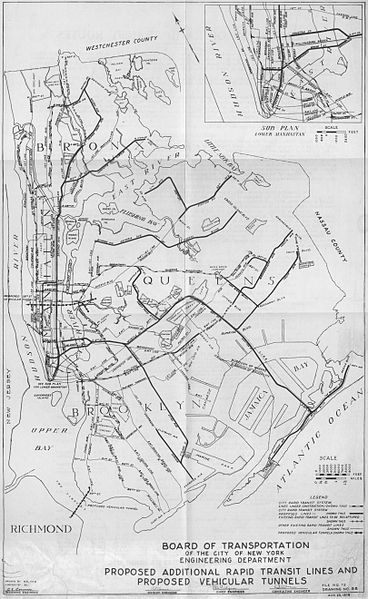
- ^ Duffus, R.L. (September 22, 1929). "Our Great Subway Network Spreads Wider; New Plans of Board of Transportation Involve the Building of More Than One Hundred Miles of Additional Rapid Transit Routes for New York" (PDF). The New York Times. Archived from the original on October 30, 2021. Retrieved August 19, 2015.
- ^ Proposed Additional Rapid Transit Lines And Proposed Vehicular Tunnel. Board of Transportation of the City of New York Engineering Department. August 23, 1929. Archived from the original on January 22, 2018. Retrieved January 21, 2018.
- ^ Newspapers.com.
- ^ a b c d e f g h Linder, Bernard (February 2006). "Fulton Street Subway". New York Division Bulletin. 49 (2). Electric Railroader's Association: 2. Archived from the original on September 20, 2016. Retrieved August 27, 2016.
- Newspapers.com.
- ^ "Storm Causes Subway Tie-Up Lasting Hours". The Sun (New York City). Fultonhistory.com. August 27, 1941. p. 2. Retrieved July 20, 2018.
- Newspapers.com.
- ^ Newspapers.com.
- ^ Newspapers.com.
- Newspapers.com.
- ^ .
- ^ a b "Signaling and Interlocking On New Line of New York Subways". Railway Signaling and Communications. Simmons-Boardman Publishing Corporation.: 578–583 September 1949. Archived from the original on February 12, 2018. Retrieved December 27, 2016.
- ^ a b "Buttons to Speed Travel in Subway: $2,000,000 System of Signals Soon to Be in Operation on Brooklyn IND Division" (PDF). The New York Times. November 12, 1948. Archived from the original on July 2, 2022. Retrieved December 27, 2016.
- ^ ISBN 978-0-82325-369-2.
- ^ a b c "4 Stations Opened By IND in Brooklyn: Mayor and Officials Inspect Fulton St. Line Extension to New Euclid Ave. Stop" (PDF). The New York Times. November 29, 1948. Retrieved December 27, 2016.
- ^ a b "First Leg of Rockaways Transit Opened at Cost of $10,154,702" (PDF). The New York Times. April 30, 1956. Archived from the original on July 2, 2022. Retrieved June 29, 2015.
- ^ "NYC Transit's Goals for 2002" (PDF). The Bulletin. Vol. 45, no. 10. Electric Railroaders' Association. October 2002. p. 1. Archived (PDF) from the original on July 1, 2022. Retrieved February 27, 2022.
- ^ Chan, Sewell (October 29, 2005). "New Elevators in Subways Are Delayed". The New York Times. Archived from the original on January 22, 2018. Retrieved September 13, 2015.
- ^ a b "NYC Official Accessibility Guide" (PDF). nyc.gov. City of New York. 2008. Archived from the original (PDF) on August 7, 2015. Retrieved September 20, 2015.
- ^ "C Subway Timetable, Effective June 26, 2022". Metropolitan Transportation Authority. Retrieved August 26, 2023.
- ^ a b "A Subway Timetable, Effective June 26, 2022". Metropolitan Transportation Authority. Retrieved August 26, 2023.
- ^ "Subway Map" (PDF). Metropolitan Transportation Authority. September 2021. Retrieved September 17, 2021.
- ^ a b c Caputo, Michael (1948). "Euclid Avenue subway station". Brooklyn Public Library, Brooklyn Collection. Retrieved October 9, 2015.
- ^ a b Pfuhler, Frank (November 23, 1948). "Interlocking Machine, Euclid Ave Station, "A" Line". nycsubway.org. Archived from the original on December 27, 2016. Retrieved December 27, 2016.
- ^
- "MTA Neighborhood Maps: East New York" (PDF). mta.info. Metropolitan Transportation Authority. 2015. Archived (PDF) from the original on July 24, 2015. Retrieved July 19, 2015.
- "MTA Neighborhood Map: Woodhaven" (PDF). mta.info. Metropolitan Transportation Authority. 2015. Archived (PDF) from the original on July 24, 2015. Retrieved July 22, 2015.
- ^ "Brooklyn Bus Map" (PDF). Metropolitan Transportation Authority. October 2020. Retrieved December 1, 2020.
- ^ Review of the A and C Lines (PDF) (Report). Metropolitan Transportation Authority. December 11, 2015. Archived from the original (PDF) on February 3, 2020. Retrieved January 19, 2016.
- Dropbox. Retrieved April 27, 2018.
- ^ a b c d e f g h i j k l m Kennedy, Randy (January 21, 2003). "TUNNEL VISION; Next Stop, 'Twilight Zone' (a k a 76th St. Station)". The New York Times. Archived from the original on April 23, 2014. Retrieved April 17, 2014.
- ^ "Complete Text of TA's Queens Subway Plan". Long Island Star-Journal. Fultonhistory.com. April 1, 1963. p. 8. Retrieved April 27, 2016.
- ^ a b c d e "LTV Exploration // Abandoned subway stations, industrial buildings, and general decay in NYC". ltvsquad.com. Archived from the original on May 5, 2013.
- ^ a b c d e f g "76th street – the puzzling evidence". ltvsquad.com. November 9, 2015. Archived from the original on June 7, 2016.
- ^ "Tech Talk". New York Division Bulletin. 47 (5). Electric Railroader's Association: 6. May 2004. Archived from the original on March 4, 2016. Retrieved August 27, 2016.
- ^ Freeman, Ira Henry (June 28, 1956). "Rockaway Trains to Operate Today" (PDF). The New York Times. Archived from the original on May 20, 2022. Retrieved June 29, 2015.
- ^ "New Subway Unit Ready: Far Rockaway IND Terminal Will Be Opened Today" (PDF). The New York Times. January 16, 1958. Archived from the original on May 20, 2022. Retrieved June 29, 2015.
External links
- nycsubway.org – IND Fulton: Euclid Avenue
- Station Reporter — C train
- Station Reporter — A Lefferts
- Station Reporter — A Rockaway
- The Subway Nut — Euclid Avenue Pictures
- Euclid Avenue entrance from Google Maps Street View
- Platforms from Google Maps Street View
| Fulton St. Line |
|
|---|---|
| |