
34th Street–Penn Station (IND Eighth Avenue Line)
34 Street–Penn Station Penn Station) | ||||||||||||||||||||||||||||||||||||||||||||||||||||||||||||||||||||||||||||||||||||||||||||||||||||||||||||||||||||||||||||||||||||||||||||
|---|---|---|---|---|---|---|---|---|---|---|---|---|---|---|---|---|---|---|---|---|---|---|---|---|---|---|---|---|---|---|---|---|---|---|---|---|---|---|---|---|---|---|---|---|---|---|---|---|---|---|---|---|---|---|---|---|---|---|---|---|---|---|---|---|---|---|---|---|---|---|---|---|---|---|---|---|---|---|---|---|---|---|---|---|---|---|---|---|---|---|---|---|---|---|---|---|---|---|---|---|---|---|---|---|---|---|---|---|---|---|---|---|---|---|---|---|---|---|---|---|---|---|---|---|---|---|---|---|---|---|---|---|---|---|---|---|---|---|---|---|
| Structure | Underground | |||||||||||||||||||||||||||||||||||||||||||||||||||||||||||||||||||||||||||||||||||||||||||||||||||||||||||||||||||||||||||||||||||||||||||
| Platforms | 2 side platforms (local) 1 island platform (express) | |||||||||||||||||||||||||||||||||||||||||||||||||||||||||||||||||||||||||||||||||||||||||||||||||||||||||||||||||||||||||||||||||||||||||||
| Tracks | 4 | |||||||||||||||||||||||||||||||||||||||||||||||||||||||||||||||||||||||||||||||||||||||||||||||||||||||||||||||||||||||||||||||||||||||||||
| Other information | ||||||||||||||||||||||||||||||||||||||||||||||||||||||||||||||||||||||||||||||||||||||||||||||||||||||||||||||||||||||||||||||||||||||||||||
| Opened | September 10, 1932[2] | |||||||||||||||||||||||||||||||||||||||||||||||||||||||||||||||||||||||||||||||||||||||||||||||||||||||||||||||||||||||||||||||||||||||||||
| Accessible | ||||||||||||||||||||||||||||||||||||||||||||||||||||||||||||||||||||||||||||||||||||||||||||||||||||||||||||||||||||||||||||||||||||||||||||
| Opposite- direction transfer | Yes | |||||||||||||||||||||||||||||||||||||||||||||||||||||||||||||||||||||||||||||||||||||||||||||||||||||||||||||||||||||||||||||||||||||||||||
| Traffic | ||||||||||||||||||||||||||||||||||||||||||||||||||||||||||||||||||||||||||||||||||||||||||||||||||||||||||||||||||||||||||||||||||||||||||||
| 2023 | 16,974,543[3] | |||||||||||||||||||||||||||||||||||||||||||||||||||||||||||||||||||||||||||||||||||||||||||||||||||||||||||||||||||||||||||||||||||||||||||
| Rank | 6 out of 423[3] | |||||||||||||||||||||||||||||||||||||||||||||||||||||||||||||||||||||||||||||||||||||||||||||||||||||||||||||||||||||||||||||||||||||||||||
| ||||||||||||||||||||||||||||||||||||||||||||||||||||||||||||||||||||||||||||||||||||||||||||||||||||||||||||||||||||||||||||||||||||||||||||
| ||||||||||||||||||||||||||||||||||||||||||||||||||||||||||||||||||||||||||||||||||||||||||||||||||||||||||||||||||||||||||||||||||||||||||||
| ||||||||||||||||||||||||||||||||||||||||||||||||||||||||||||||||||||||||||||||||||||||||||||||||||||||||||||||||||||||||||||||||||||||||||||
| ||||||||||||||||||||||||||||||||||||||||||||||||||||||||||||||||||||||||||||||||||||||||||||||||||||||||||||||||||||||||||||||||||||||||||||
| ||||||||||||||||||||||||||||||||||||||||||||||||||||||||||||||||||||||||||||||||||||||||||||||||||||||||||||||||||||||||||||||||||||||||||||


34th Street–Penn Station is an express
History
Construction and opening
New York City mayor John Francis Hylan's original plans for the Independent Subway System (IND), proposed in 1922, included building over 100 miles (160 km) of new lines and taking over nearly 100 miles (160 km) of existing lines. The lines were designed to compete with the existing underground, surface, and elevated lines operated by the IRT and Brooklyn–Manhattan Transit Corporation (BMT).[5][6] On December 9, 1924, the New York City Board of Transportation (BOT) gave preliminary approval to the construction of a subway line along Eighth Avenue, running from 207th Street.[7] The BOT announced a list of stations on the new line in February 1928, with an express station at 33rd Street.[8]
Most of the Eighth Avenue Line was dug using a cheap
A preview event for the new subway was hosted on September 8, 1932, two days before the official opening.
Later years
The station's token booths were shuttered in May 2005, after fare tokens were replaced with MetroCards; station agents were deployed elsewhere in the station to answer passengers' queries. This was part of a pilot program that was tested at seven other stations.[21]
Under the 2015–2019
Station layout
| G | Street level | Entrances/exits Elevators at:
|
| B1 Platform level | ||
| Side platform | ||
| Northbound local | ← ← ← | |
| Northbound express | ← | |
| Island platform | ||
| Southbound express | or Rockaway Park–Beach 116th Street (14th Street) → | |
| Southbound local | | |
| Side platform | ||
| B2 | Mezzanine | Connector between platforms, connection to Penn Station
|
There are four tracks, two
South of the station, an additional track begins at a
The walls of the station contain red-tile bands bordered in black; since 34th Street is an express station, it has a wider tile band than local stations. The tile colors are intended to help riders identify their station more easily, part of a color-coded tile system for the entire Independent Subway System.[30] The tile colors were designed to facilitate navigation for travelers going away from Lower Manhattan; on the Eighth Avenue Line, the tiles change color at the next express station to the north. Because the next station to the north, 42nd Street–Port Authority Bus Terminal, is an express station, the adjacent stations to the north and south both used different tile colors.[31][32]
The stations on the Eighth Avenue Line were built with 600 feet (180 m) long platforms, but there were provisions to lengthen them to 660 feet (200 m) to accommodate eleven-car trains.[33]: 70 Below the red band are small tile captions reading "34" in stretched Arial font, though these are not original to the station. Originally the station had no trim line and the tile captions were in the standard IND caption font. The original mosaic name tablets however are still visible, being surrounded by new black tiles; The mosaics read "34TH STREET PENN. STATION" broken onto two lines on a claret background and same claret border. Red I-beam columns run along all the platforms at regular intervals, alternating ones having the standard black station name plate with white lettering.
Like other subway stations, 34th Street–Penn Station includes black-and-white "sighting boards" for conductors to point and call, thereby indicating to the motorman that the train has stopped at the right position. On the downtown express platform, there is a blue-and-white sighting board for the R110B, a now-retired prototype New Technology Train whose conductor's cab was not aligned with any other fleet's conductors' cabs. This board is still extant and is one of a few publicly visible remnants of the R110B's operation.[citation needed]
| 11th Av | 10th & 9th Avs are skipped |
Farley Building & Moynihan Train Hall |
8th Av | Madison Square Garden |
7th Av | Storefronts | 6th Av & Broadway |
5th & Madison Avs are skipped |
Park Av | ||
mezzanine
|
train hall | A / C / E | concourse
|
1 / 2 / 3 | Former Gimbel's
passageway |
mezz
|
PATH | 6 / <6>
| |||
mezzanine
|
conc
|
mezzanine | concourse
|
mezzanine | N / Q / R / W
|
||||||
7 / <7>
|
Penn Station (Platform Level)
|
B/D/F/<F>/M
| |||||||||
Exits
34th Street–Penn Station spans three streets (33rd, 34th, and 35th Streets) with a set of entrances/exits at all of these streets. For the purposes of this article, entrance and exit are interchangeable.[34] When the station opened, it contained 17 entrances and exits, more than almost any other station on the Eighth Avenue Line except for Chambers Street/Hudson Terminal.[16]
At 35th Street is a part-time booth entrance. Each local platform has its own fare control. On the local platforms, there are
At 34th Street is a part-time booth entrance. Each local platform has its own fare control. There is an underpass connecting the platforms inside fare control, and it leads to the LIRR West Side Concourse outside of fare control. There is also a passageway providing out-of-system access to the
At 33rd Street is the full-time entrance, with token booths on both sides; the full-time booth is on the northbound platform. All three platforms have their own fare control. The underpass connecting the platforms is outside fare control. The northbound local platform's fare control leads to a street stair to the northeast corner of 33rd Street and Eighth Avenue, as well as a direct passageway to the basement of Penn Station/Madison Square Garden. The southbound local platform's fare control leads to a street stair to the northwest corner of 33rd Street and Eighth Avenue, as well as a double-wide granite staircase at the southwest corner (in a plaza outside the
Gallery
-
 Entrance outside Moynihan Train Hall
 -
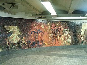 Detail of "The Garden of Circus Delights" mosaic beneath the platforms


References
- ^ "Glossary". Second Avenue Subway Supplemental Draft Environmental Impact Statement (SDEIS) (PDF). Vol. 1. Metropolitan Transportation Authority. March 4, 2003. pp. 1–2. Archived from the original (PDF) on February 26, 2021. Retrieved January 1, 2021.
- ^ ISSN 0362-4331. Retrieved April 21, 2020.
- ^ a b "Annual Subway Ridership (2018–2023)". Metropolitan Transportation Authority. 2023. Retrieved April 20, 2024.
- ^ "Annual Subway Ridership (2018–2023)". Metropolitan Transportation Authority. 2023. Retrieved April 20, 2024.
- ISSN 0362-4331. Retrieved August 1, 2019.
- ISSN 0362-4331. Retrieved August 1, 2019.
- from the original on June 14, 2018. Retrieved June 29, 2018.
- ProQuest 1113431477.
- from the original on May 3, 2018. Retrieved May 2, 2018.
- ^ ProQuest 1113431484.
- ^ ISSN 0362-4331. Retrieved December 2, 2022.
- ISSN 0362-4331. Retrieved April 29, 2023.
- ISSN 0362-4331. Retrieved March 15, 2023.
- ProQuest 1331181357.
- from the original on July 1, 2022. Retrieved July 1, 2022.
- ^ ProQuest 1125436641.
- ^ Crowell, Paul (September 10, 1932). "Gay Midnight Crowd Rides First Trains In The New Subway: Throngs at Station an Hour Before Time, Rush Turnstiles When Chains are Dropped" (PDF). The New York Times. Retrieved November 8, 2015.
- ProQuest 1114839882.
- ProQuest 1113474993.
- ISSN 0362-4331. Retrieved April 29, 2023.
- from the original on May 29, 2015. Retrieved August 19, 2016.
- ^ "Enhanced Station Initiative: CCM Pre-Proposal Conference" (PDF). Metropolitan Transportation Authority. October 25, 2016. p. 8 (PDF page 15). Retrieved August 11, 2017.
- ^ "NYCT/Bus Committee Meeting" (PDF). Metropolitan Transportation Authority. January 22, 2018. p. 135. Archived from the original (PDF) on January 27, 2018. Retrieved January 19, 2018.
- ^ Barone, Vincent (January 24, 2018). "Controversial cosmetic subway improvement plan falters". am New York. Retrieved January 25, 2018.
- ^ Siff, Andrew (January 24, 2018). "MTA Shelves Plan to Modernize Subway Stations Amid Criticism". NBC New York. Retrieved January 25, 2018.
- ^ "Foes Hit Gov's Station Fix Plan". NY Daily News. February 13, 2018. Retrieved February 23, 2018.
- ^ "NYCT/Bus Committee Meeting" (PDF). Metropolitan Transportation Authority. May 20, 2019. p. 168. Retrieved May 19, 2019.
- ISSN 0362-4331. Retrieved June 3, 2023.
- Dropbox. Retrieved April 27, 2018.
- from the original on July 1, 2022. Retrieved July 1, 2022.
- ^ Carlson, Jen (February 18, 2016). "Map: These Color Tiles In The Subway System Used To Mean Something". Gothamist. Retrieved May 10, 2023.
- ^ Gleason, Will (February 18, 2016). "The hidden meaning behind the New York subway's colored tiles". Time Out New York. Retrieved May 10, 2023.
- ^ Transit Journal. McGraw-Hill Publishing Company, Incorporated. 1932. Archived from the original on June 20, 2022. Retrieved June 20, 2022.
- ^ a b c d "MTA Neighborhood Maps: Pennsylvania Station / Times Square" (PDF). mta.info. Metropolitan Transportation Authority. 2015. Retrieved December 11, 2015.
- ProQuest 1676761821.
- ^ Young, Michelle (September 13, 2016). "The Top 10 Secrets of the New Yorker Hotel". Untapped New York. Retrieved November 28, 2022.
- ISSN 0362-4331. Retrieved November 30, 2022.
- ^ "NYC's Moynihan Train Hall is about to transform travel". BostonGlobe.com. December 28, 2020. Retrieved December 2, 2022.
External links
- nycsubway.org – IND 8th Avenue: 34th Street/Penn Station
- nycsubway.org — Garden of Circus Delights Artwork by Eric Fischl (2001)
- MTA's Arts For Transit — 34th Street–Penn Station (IND Eighth Avenue Line)
| Headhouses |  | |
|---|---|---|
| Connections |
| |
| Nearby buildings | ||
| History | ||
| Operators |
| |
| Eighth Ave. Line |
|
|---|---|
| |