
Fort Tejon
Fort Tejon | |
 Fort Tejon Barracks | |
| Nearest city | Lebec, California |
|---|---|
| Built | 1854 |
| NRHP reference No. | 71000140 |
| CHISL No. | 129[1] |
| Significant dates | |
| Added to NRHP | 1971 |
| Designated CHISL | 1954 |
Fort Tejon in California is a former United States Army outpost which was intermittently active from June 24, 1854, until September 11, 1864. It is located in the Grapevine Canyon (La Cañada de las Uvas) between the San Emigdio Mountains and Tehachapi Mountains. It is in the area of Tejon Pass along Interstate 5 in Kern County, California, the main route through the mountain ranges separating the Central Valley from the Los Angeles Basin and Southern California. The fort's location protected the San Joaquin Valley from the south and west.
Purpose
The fort's mission was to suppress
History

At the urging of Edward Fitzgerald Beale, Superintendent of Indian Affairs in California, the U.S. Army established Fort Tejon in 1854. Fort Tejon was the headquarters of the First U.S. Dragoons until those Regular Army troops were transferred to the East in July 1861 soon after the outbreak of the American Civil War. The fort was re-occupied by California volunteer troops in 1863. Those units included Companies D, E and G of the 2nd California Volunteer Cavalry from July 6 to August 17, 1863; and Company B of the 2nd California Volunteer Infantry, which remained there until Fort Tejon was abandoned for good on September 11, 1864.[2]
The fort lay along the
The great earthquake of 1857, which became known as the
Fort Tejon State Historic Park
The state historic park is listed on the
A quartermaster building has been reconstructed[4] and houses materials used in dragoon life and Civil War reenactments. The sites of former buildings, planned for reconstruction, are marked by split rail fences along the outlines of their foundations. A park office, containing exhibits of dragoon life and restrooms, is at the east end of the parade ground near the parking lot by Interstate 5.
The park grounds include the original barracks, where the soldiers slept, and also the grave site of Peter Lebeck, which is indicated with a historical marker. The nearby town of Lebec is named after him.[5]
Fort Tejon is the site of frequent Civil War reenactments presented by the Fort Tejon Historical Association.[6]
The park contains a number of natural features of interest, including centuries-old
1857 Fort Tejon earthquake
The Fort Tejon earthquake occurred at about 8:20 AM (Pacific time) on January 9, 1857. It ruptured the
See also
- Fort Tejon Historical Association
- California Historical Landmarks in Kern County
- California Historical Landmark
References
- ^ "Fort Tejon". Office of Historic Preservation, California State Parks. Retrieved 2012-10-07.
- ^ "2nd California Volunteer Cavalry", Civil War Archive Website, accessed 11-11-08
- OCLC 50174716.
- ^ a b c "Fort Tejon State Historic Park" (PDF). California State Parks. Retrieved 8 January 2022.
- ^ "Peter Lebeck", Historical Marker Database
- ^ Fort Tejon State Historic Park pamphlet, State of California, Department of Parks & Recreation, Sacramento, California, 1991.
- California Department of Parks and Recreation. Retrieved 8 January 2022.
-
 East end of the restored barracks building. The unreconstructed kitchen/mess hall is outlined by split rail fence to the left.
 -
 Barracks interior showing soldiers' quarters.
 -
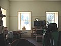 The day room in the barracks.
 -
 Uniform items on display in the day room.
 -
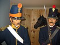 One of the several uniform displays in the barracks.
 -
 Model of Dragoon in the barracks.
 -
 View of the barracks from the front porch of the commanding officer's quarters. The split rail fence at the near end of the barracks denotes the foundation outline of another barracks yet to be reconstructed.
 -
 The quartermaster building.
 -
 The interior of the quartermaster building showing materials used during Dragoon and Civil War reenactments staged at Fort Tejon.
 -
 The restored commanding officer's quarters.
 -
 A furnished room inside the commanding officer's quarters.
 -
 The dining room inside the commanding officer's quarters.
 -
 Bedroom for the children and servant on the second floor of the commanding officer's quarters.
 -
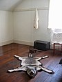 Wolf rug in the adults' bedroom on the second floor of the commanding officer's quarters.
 -
 The roof of the commanding officer's quarters receiving new shingles, showing the detail of roof construction.
 -
 Officers' quarters. This building has been stabilized but not restored, and is not open to the public. The interiors may be viewed through the wire fencing.
 -
 Detail showing the interior wall bracing needed to stabilize the structure of the officers' quarters.
 -
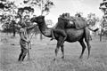 Army Camel Corp training
 -
 Army Camel Corp monument


External links
Fort Tejon State Historic Park.
- Official Fort Tejon State Historic Park website
- The Fort Tejon Historical Association
- Historic American Buildings Survey (HABS) No. CA-39, "Fort Tejon, Highway 99, Lebec vicinity, Kern County, CA"
- HABS No. CA-39-A, "Fort Tejon, Barracks Number One"
- HABS No. CA-39-B, "Fort Tejon, Barracks Number Two"
- HABS No. CA-39-C, "Fort Tejon, Officers' Quarters"
- HABS No. CA-39-D, "Fort Tejon, Soldiers' Quarters"
- HABS No. CA-39-E, "Fort Tejon, Smokehouse"