
Gulf of Porto
| Gulf of Porto | |
|---|---|
Porto River | |
| Ocean/sea sources | Mediterranean Sea, Atlantic Ocean |
| Basin countries | France |
| Designation | Regional Natural Park of Corsica |
| Max. length | 7 mi (11 km)[1] |
| Max. width | 5 mi (8.0 km)[1] |
UNESCO World Heritage Site | |
|---|---|
| Official name | Gulf of Porto: Calanche of Piana, Gulf of Girolata, Scandola Reserve |
| Location | Corsica, France |
| Criteria | Natural: (vii), (viii), (x) |
| Reference | 258 |
| Inscription | 1983 (7th Session) |
The Gulf of Porto is a gulf of the Mediterranean Sea located on the western façade of the island of Corsica, France, well known for its dramatic coloration and rugged cliffs.[1][2] The gulf is located within the department of Corse-du-Sud. The gulf and surrounding coast is part of the Regional Natural Park of Corsica. In 1983 the gulf was designated as a UNESCO World Heritage Site, encompassing the Calanques de Piana, Gulf of Girolata, and Scandola Nature Reserve, due to its outstanding scenery, rich avian and marine life, and maquis shrubland.[3]
Geography and Biodiversity
The Gulf of Porto is bounded by five
The coastal and marine biodiversity along the Gulf of Porto is very rich. The
History
The Porto-Piana region has historically been sparsely populated as a result of its rugged terrain and turbulent history. A series of recurring plagues from the mid 15th to late 16th centuries, followed by food shortages and famines from the 16th to 18th centuries decimated the area's population.[5] Toward the end of the Middle Ages, the gulf area was under the lordship of the Leca, one of the Cinarchesi noble houses. At the end of the 15th century, Count Giovan Paolo di Leca plunged the region into conflict.[6]
During the second half of the 16th century, Barbary corsairs regularly assaulted the Corsican coast, prompting the construction of a number of coastal defenses collectively referred to as the Genoese towers in Corsica. Three such towers were located on the coast of the Gulf of Porto: Torra di l'Isula di Gargali, on the eponymous islet off the west coast near Osani, Torra di Portu, at the head of the gulf in Ota, and Torra di Turghju, on the gulf's south coast in Piana.[7]
Despite these fortifications, raiding by the corsairs eventually eliminated entire villages, including Paomia and Revinda. At the end of the 16th century, the coastal lowlands were described as being completely abandoned: "So it is with Sia, the pit of Salogna, ruined, or that of Paomia, completely deserted in 1584."[7] By the start of the 17th century, it was clear that Corsica was not defensible. Residents of the mountain villages who owned land on the coast lobbied for the construction of a larger number of fortifications, resulting in the reconstruction of a tower in Sagone, as well as six other new towers: Omigna, Cargèse, Orchinu, Cavi Rossi, Gargalo and Imbuto. These six towers were built between 1605 and 1611 under the direction of the architect Anton Giovanni Sarola. During this time, Genoan authorities developed a policy of concessions, leading in particular to the establishment in Cargèse of a Greek colony which caused tension with the surrounding population.[7]
In his travel account Une excursion en Corse, published in 1891, Prince
Gallery
-
 Beach at the head of the gulf
 -
 South shore of the gulf showing Genoese tower
 -
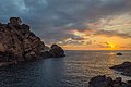 The Genoese tower at sunset
 -
 Another angle of the tower


See also
References
- ^ ISBN 0-89577-087-3.
- ^ a b Bonaparte, Roland (1891). Une excursion en Corse (in French).
- ^ a b "Gulf of Porto: Calanche of Piana, Gulf of Girolata, Scandola Reserve". UNESCO World Heritage Centre. United Nations Educational, Scientific, and Cultural Organization. Retrieved 16 October 2021.
- ^ ISBN 978-94-024-1526-1.)
{{cite book}}: CS1 maint: location missing publisher (link - ^ "Canton : Les Deux-Sevi". 2011-10-06. Archived from the original on 2011-10-06. Retrieved 2020-11-01.
- ^ "Canton : Les Deux-Sevi". 2011-10-06. Archived from the original on 2011-10-06. Retrieved 2020-11-01.
- ^ a b c "Canton : Les Deux-Sevi". 2011-10-06. Archived from the original on 2011-10-06. Retrieved 2020-11-01.
| International | |
|---|---|
| Other | |