
Harbor Springs, Michigan
Harbor Springs, Michigan | ||
|---|---|---|
FIPS code 26-36560[3] | | |
| GNIS feature ID | 0627758[2] | |
| Website | Official website | |
Harbor Springs is a city and resort community in
Harbor Springs is in a sheltered bay on the north shore of the
The area is known for its historic summer resorts, such as
History
.jpg)
The European-American settlement started with a mission by French Catholic Jesuits; they called this area L'Arbre Croche, meaning Crooked Tree. In 1847, L'Arbre Croche had the largest concentration of Native Americans in Michigan.[5] French traders renamed the area Petit Traverse, or Little Crossing, when they arrived in the area. After more settlers came from the eastern United States, they changed the name of the village to Harbor Springs, incorporating it in 1880.
The federally recognized Little Traverse Bay Bands of Odawa Indians are descendants of the numerous Odawa bands that occupied this area. They have their tribal offices in Harbor Springs and a gaming resort in Petoskey.

The Douglas House on the shore of Lake Michigan was designed by architect Richard Meier and completed in 1973. This house is one of 150 structures listed in 2007 as America's Favorite Architecture by the American Institute of Architects.[7]
The
Geography
According to the United States Census Bureau, the city has a total area of 1.30 square miles (3.37 km2), all of it land.[8]
Climate
The climate is described as Humid Continental by the Köppen Climate System, abbreviated as Dfb.[9]
Demographics
| Census | Pop. | Note | %± |
|---|---|---|---|
| 1880 | 164 | — | |
| 1890 | 1,052 | 541.5% | |
| 1900 | 1,643 | 56.2% | |
| 1910 | 1,805 | 9.9% | |
| 1920 | 1,600 | −11.4% | |
| 1930 | 1,429 | −10.7% | |
| 1940 | 1,423 | −0.4% | |
| 1950 | 1,626 | 14.3% | |
| 1960 | 1,433 | −11.9% | |
| 1970 | 1,662 | 16.0% | |
| 1980 | 1,567 | −5.7% | |
| 1990 | 1,540 | −1.7% | |
| 2000 | 1,567 | 1.8% | |
| 2010 | 1,194 | −23.8% | |
| 2020 | 1,274 | 6.7% | |
| U.S. Decennial Census[10] | |||
2010 census
As of the
There were 558 households, of which 19.4% included children under the age of 18, 38.4% were married couples living together, 10.0% had a female householder with no husband present, 4.3% had a male householder with no wife present, and 47.3% were non-families. 43.7% of all households were made up of individuals, and 23.1% had someone living alone who was 65 years of age or older. The average household size was 1.93 and the average family size was 2.66.
The median age in the city was 55.8 years. 15.7% of residents were under the age of 18; 4.9% were between the ages of 18 and 24; 14.7% were from 25 to 44; 32.6% were from 45 to 64; and 32.2% were 65 years of age or older. The gender makeup of the city was 43.8% male and 56.2% female.
2000 census
| Largest ancestries (2000) | Percent |
|---|---|
| German |
17.4% |
| English |
16.2% |
| Irish |
14.1% |
French |
7.4% |
| Polish |
6.7% |
American |
6.2% |
| Odawa |
4.34% |
As of the
There were 683 households, out of which 23.0% had children under the age of 18 living with them, 46.0% were married couples living together, 7.8% had a female householder with no husband present, and 43.8% were non-families. 39.4% of all households were made up of individuals, and 18.0% had someone living alone who was 65 years of age or older. The average household size was 2.14 and the average family size was 2.88.

In the city, the population was spread out, with 20.4% under the age of 18, 4.6% from 18 to 24, 22.8% from 25 to 44, 28.3% from 45 to 64, and 23.8% who were 65 years of age or older. The median age was 47 years. For every 100 females, there were 81.6 males. For every 100 females age 18 and over, there were 74.4 males.
The median income for a household in the city was $35,341, and the median income for a family was $46,750. Males had a median income of $29,236 versus $27,167 for females. The
Transportation
Airports
- The nearest airports with scheduled passenger service are in Pellston Regional Airport[12] and Traverse City Cherry Capital Airport.
- Harbor Springs Municipal Airport is a public general aviation with no scheduled commercial flights.

Highways
 Tunnel of Trees to a terminus at Cross Village. East of the city, the highway continues along the shore of Little Traverse Bay before terminating at US Highway 31 (US 31), which can be used to access Petoskey.
 C-77 is a north–south route beginning at Harbor Springs and continuing north to Cross Village.
 C-81 is a north–south route running from just east of the city northerly toward Mackinaw City.
Notable people
- Odawa (Ottawa)tribe leader and historian
- Jocko Cunningham, racing driver
- Robert Klark Graham, inventor, eugenicist, businessman.
- F. James McDonald, former president and chief operating officer of General Motors.[13]
- Joe Dart, musician
- Hord Hardin, chairman of the Augusta National Golf Club, 1980-1991.
Images
-
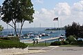 Harbor
 -
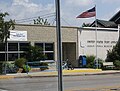 Post office
 -
 Sign on M-119
 -
 View of downtown from the bluff


References
- ^ "2020 U.S. Gazetteer Files". United States Census Bureau. Retrieved May 21, 2022.
- ^ a b U.S. Geological Survey Geographic Names Information System: Harbor Springs, Michigan
- ^ a b "U.S. Census website". United States Census Bureau. Retrieved January 31, 2008.
- ^ US Census Bureau, 2020 Report, Harbor Springs city, Michigan https://www.census.gov/search-results.html?searchType=web&cssp=SERP&q=Harbor%20Springs%20city,%20Michigan
- ^ "Seeing The Light - Little Traverse Lighthouse". Terrypepper.com. Retrieved July 20, 2019.
- ^ Shay Elementary Archived 2006-07-16 at the Wayback Machine
- ^ "America's Favorite Architecture". American Institute of Architects. 2007. Archived from the original on May 10, 2011.
- ^ "US Gazetteer files 2010". United States Census Bureau. Archived from the original on July 2, 2012. Retrieved November 25, 2012.
- ^ "Harbor Springs, Michigan Travel Weather Averages (Weatherbase)". Weatherbase.
- ^ "Census of Population and Housing". Census.gov. Retrieved June 4, 2015.
- ^ "U.S. Census website". United States Census Bureau. Retrieved November 25, 2012.
- ^ "Pellston Regional Airport Serving Northern Michigan Emmet County". pellstonairport.com.
- ^ via Associated Press. "F. James McDonald, Former G.M. President, Is Dead at 87", The New York Times, June 15, 2010. Accessed July 2, 2010.
External links
Municipalities and communities of Emmet County, Michigan, United States | ||
|---|---|---|
| Cities |  | |
| Villages | ||
| Townships | ||
| CDPs | ||
| Other communities |
| |
| Ghost towns |
| |
| Indian reservations | ||
| Historic settlements |
| |
| Footnotes | ‡This populated place also has portions in an adjacent county or counties | |
| ||
| International | |
|---|---|
| National | |
| Geographic | |
| Other | |