
Hauz Khas
Hauz Khas | |
|---|---|
District Subdivision | |
UTC+5:30 (IST ) | |
| Telephone code | 011 |
Hauz Khas is a neighborhood in
Hauz Khas is also home to various diplomatic missions such as the ones of
Hauz Khas is witnessing the growth of trendy shops and lodgings.
History


Hauz Khas is named after an ancient water reservoir by the same name, now part of the extensive
Geography
It was developed during the 1960s by DLF (company) (Delhi Land & Finance Ltd.) as Hauz Khas Enclave. Later it was made a district of South Delhi encompassing some more neighboring areas.
Hauz Khas (Enclave) as known, consists of A,B,C,D,E,F,G,H,K,L,M,P,Q,R,X,Y,Z Blocks.
E block is the Main market here and lies in the middle of the colony. It includes a multi-level parking lot. G block and Aurobindo Market are other markets close by.
Mayfair Gardens is an independent small private colony inside Hauz Khas, neighboured by Padmini Enclave.
Hauz Khas has some of the largest green areas in Delhi, namely
It is near the two major hospitals in Delhi, AIIMS and Safdarjung Hospital.
As Hauz Khas now is administered as a district, it is also known as a reference for other areas like Mayfair Gardens, Padmini Enclave, Safdarjung Enclave, Hauz Khas Village, Kalu Sarai, IIT-Delhi, Shahpur Jat, Asiad Village, Katwaria Sarai and institutional areas like on Sirifort Road and Aurobindo Marg.
Hauz Khas village

The success of Hauz Khas village has led to the development of Shahpur Jat and Lado Sarai as fashion and design markets also in the South Delhi area.[5][9]
-
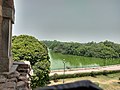
 Lake in Hauz Khas Village in the year 2014.
 -
 Skyview of lake
 -
 Islamic monument at Hauz Khas
 -
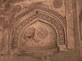 Arc and wall design
 -
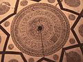 Dome design inside the tomb
 -
 Munda Gumbad in Deer Park


Points of interest and tourism
Historical Places like the Hauz Khas Complex which consists of the Hauz Khas Lake or Royal Tank, a mosque and a tomb, all from the time of the Khalji dynasty. Neeli Masjid and Chor Minar, where the heads of executed thieves (chor) would be put on display in the earlier days, lie inside the colony.
Nearby landmarks include Siri Fort Auditorium, Siri Fort Sports Complex, HUDCO Place and Yusuf Sarai Community Centre.
Hauz Khas is witnessing the growth of trendy shops and lodgings.
Accessibility
The domestic terminal of Indira Gandhi International Airport (Terminal 1) is 11 kilometres (6.8 mi) from Hauz Khas while the international terminal (Terminal 3) is 16 kilometres (9.9 mi).
Hazrat Nizamuddin railway station lies 8 kilometres (5.0 mi) away.
The
The Hauz Khas Bus Stand is also situated towards the Outer Ring Road.
Education
Hauz Khas houses engineering and management colleges like the
Hauz Khas also contains private schools such as Laxman Public School and General Raj's School and a school run by the Aurobindo society
Nearby
Fastbooktrip, Institute of Home Economics, Gaudiya Math, Panchshila Club, Chor Minar, IDGAH, DDA Sarvpriya Vihar Park
References
- ^ Benroider, Lucie (2015). "Dynamics of social change in South Delhi's Hauz Khas Village" (PDF). soas.ac.uk. Retrieved 15 August 2020.
- ^ a b "Backpacker haven Paharganj losing out to safer, hip hostels in south Delhi". The Times of India.
- ^ a b "Paharganj: Trap or haven for tourists?". Deccan Herald. 23 May 2012.
- ^ Y.D.Sharma (2001). Delhi and its Neighbourhood. New Delhi: Archaeological Survey of India. pp. 79–81. Archived from the original on 31 August 2005. Retrieved 24 April 2009.
{{cite book}}:|work=ignored (help) - ^ a b "Whine Not". The Indian Express. 19 July 2011. Retrieved 15 June 2013.
- ISBN 978-1-85065-176-5.
- ^ "Hauz Khas Village eateries under lens". The Times of India. 6 March 2013. Archived from the original on 8 March 2013. Retrieved 15 June 2013.
- ^ "The New, New, Hauz Khas Village". The Indian Express. 18 October 2011. Retrieved 15 June 2013.
- ^ "Delhi's soho". Hindustan Times. 15 June 2011. Archived from the original on 13 July 2015. Retrieved 16 June 2013.
- ^ Benroider, Lucie (2015). "Dynamics of social change in South Delhi's Hauz Khas Village" (PDF). soas.ac.uk. Retrieved 15 August 2020.
- ^ "Home ::". St. Anthony`s Sr. Secondary School. 5 January 1970. Retrieved 16 August 2020.