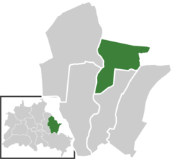
Hellersdorf
Appearance
This article needs additional citations for verification. (September 2021) |
Hellersdorf | |
|---|---|
 Hellersdorf from Kienberg | |
| Coordinates: 52°32′21″N 13°35′32″E / 52.53917°N 13.59222°E | |
| Country | Germany |
| State | Berlin |
| City | Berlin |
| Borough | Marzahn-Hellersdorf |
| Founded | 1375 |
| Subdivisions | 3 zones |
| Area | |
| • Total | 8.1 km2 (3.1 sq mi) |
| Elevation | 52 m (171 ft) |
| Population (2023-12-31)[1] | |
| • Total | 92,913 |
| • Density | 11,000/km2 (30,000/sq mi) |
| Time zone | UTC+01:00 (CET) |
| • Summer (DST) | UTC+02:00 (CEST) |
| Postal codes | 12619, 12627, 12629, 12683 |
| Vehicle registration | B |
Hellersdorf (German pronunciation: Kaulsdorf and Mahlsdorf.
History
Before
Plattenbau (concrete slab
) buildings.
The historic village of Helwichstorpp was first mentioned in a 1375 land registry of
Margrave of Brandenburg. The city of Berlin acquired the former Hellersdorf manor in 1886; it was finally incorporated by the 1920 Greater Berlin Act as a part of the Lichtenberg
borough. During German reunification on October 3, 1990, a small part of Hönow (primarily around the last two stations of U5) was annexed by this borough.
Geography
Subdivision
Hellersdorf is divided into 3 zones (Ortslagen):
- Hellersdorf-Nord
- Hellersdorf-Ost
- Hellersdorf-Süd
Transportation
Hellersdorf is served by the
.References
- Amt für Statistik Berlin-Brandenburg. February 2024.
External links
![]() Media related to Hellersdorf at Wikimedia Commons
Media related to Hellersdorf at Wikimedia Commons
- (in German) Hellersdorf page on info-marzahn-hellersdorf.de


