
Staaken
Staaken | |
|---|---|
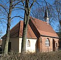
 Village church with commemoration cross to Staaken's division from 1951 to 1990 | |
Location of Staaken in Spandau district and Berlin  | |
 Staaken  Staaken | |
| Coordinates: 52°31′57″N 13°08′29″E / 52.53250°N 13.14139°E | |
| Country | Germany |
| State | Berlin |
| City | Berlin |
| Borough | Spandau |
| Founded | 1273 |
| Area | |
| • Total | 10.9 km2 (4.2 sq mi) |
| Elevation | 50 m (160 ft) |
| Population (2020-12-31)[1] | |
| • Total | 46,369 |
| • Density | 4,300/km2 (11,000/sq mi) |
| Time zone | UTC+01:00 (CET) |
| • Summer (DST) | UTC+02:00 (CEST) |
| Postal codes | (nr. 0504) 13591 |
| Vehicle registration | B |
Staaken (German pronunciation: .
History
First mentioned in a 1273 deed as Stakene (from

The former village became part of Berlin by the
In 1919 the regulations of the
Cold War

After World War II Staaken was divided by a territorial exchange contract between the
On 1 February 1951 East German
On 1 June 1952 West Staaken's de facto administration was conveyed to neighbouring East German Falkensee, which incorporated West Staaken on 1 January 1961. From 13 August the same year until its opening and removal after 9 November 1989 the Berlin Wall cut through the two parts of Staaken, with one East German border crossing on Heerstraße. Since 1 January 1971 western Staaken, officially simply named Staaken, formed a municipality of its own, with a population amounting to 4,146 at that time. On 3 October 1990, the day of unification of East Germany, East and West Berlin with the West German Federal Republic of Germany both Staakens reunited to form a locality of the Spandau Borough.
Border crossing
.png)
Albrechtshof station had been the site of a
In 1976 the GDR opened a separate rail border crossing station Staaken for rail transit to western Germany farther away from the border to West Berlin. Up to 1980 the eastern part of Staaken inside West Berlin was served by S-Bahn. This service was abandoned by the East German Reichsbahn Headquarters after the big strike of the West Berlin Reichsbahn workers. A reconnection today is highly unlikely.

The car traffic, travelling along F 5 between West Berlin and the East German Democratic Republic or the West German Federal Republic, e.g. to Hamburg, was subject to the Interzonal traffic regulations that between West Germany and West Berlin followed the special regulations of the Transit Agreement (1972).
On 1 January 1988 the transit traffic to West Berlin was redirected to the new East German Stolpe checkpoint (a part of today's Hohen Neuendorf)/West Berlin-Heiligensee. From 1988 to 9 November 1989 the Heerstraße border crossing was open for the highly restricted traffic between West Berlin and East Germany. Highly restricted in this case means citizens of West Berlin had to apply for a visiting permit to visit relatives; while only GDR citizens above the age of 65 could apply to visit relatives in West Berlin. Eastern controls were slowly eased into spot checks and finally abolished on 30 June 1990, the day East and West introduced the union concerning currency, economy and social security (German: Währungs-, Wirtschafts- und Sozialunion).
Geography
Staaken borders on the localities of
Subdivisions
The locality of Staaken includes six sites (German: Ortslagen) or neighbourhoods (Siedlungen):
- Dorf Staaken ("Staaken Village"), the historic settlement around the Alt-Staaken village church
- Albrechtshof, a family home colony in the northwest, around Berlin Albrechtshof station
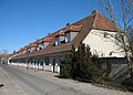
- Gartenstadt Staaken (Staaken Garden City), built from 1914 to 1917 according to plans designed by Paul Schmitthenner, today protected as a historic monument
- Neu-Jerusalem, an early example of New Objectivity residential construction along western Heerstraße, erected in 1923/24 according to plans by Erwin Anton Gutkind and Leberecht Migge
- Neu-Staaken with Louise-Schroeder-Siedlung, several housing estates built in the 1960s and 70s on former allotment land in the east which then belonged to West Berlin
- Siedlung Hahneberg, a family home estate in the southwest.
Transportation
Staaken is served by
Notable people
- Katarina Witt (born 1965), figure skater, born in the GDR municipality of Staaken
Gallery
- Staaken Garden City
-
 Garden City Church
 -
 Beim Pfarrhof
 -
 Zwischen den Giebeln
 -
 Torweg
 -
 Am langen Weg


See also
- Berlin Albrechtshof railway station
- Berlin-Staaken railway station
- Challenge 1930
- Challenge 1932
- Bullengraben
References
- ^ "Einwohnerinnen und Einwohner im Land Berlin am 31. Dezember 2020" (PDF). Amt für Statistik Berlin-Brandenburg. February 2021.
- ^ "Forgotten airfields europe". forgottenairfields.com. Retrieved 2021-01-19.
External links
- (In German) Staaken info website
- (In German) Staaken page on www.berlin.de
| International | |
|---|---|
| National | |