
Inisheer
Native name: Inis Oírr | |
|---|---|
.jpg) | |
 | |
 Inisheer | |
| Geography | |
| Location | Atlantic Ocean |
| Coordinates | 53°03′29″N 9°31′39″W / 53.05806°N 9.52750°W |
| Area | 1,448 acres (586 ha)[1] |
| Highest elevation | 62 m (203 ft)[1] |
| Administration | |
Ireland | |
| Province | Connacht |
| County | Galway |
| Demographics | |
| Population | 343 (2022)[2] |
| Pop. density | 48/km2 (124/sq mi) |

Inisheer (Irish: Inis Oírr [ˈɪnʲɪʃ iːɾˠ], Inis Thiar [ˈɪnʲɪʃ hiəɾˠ] or Inis Oirthir [ˈɪnʲɪʃ ˈɛɾʲhəɾʲ]) is the smallest and most easterly of the three Aran Islands in Galway Bay, Ireland. With 343 residents as of the 2022 census,[2] it is second-most populous of the Arans. Caomhán of Inis Oírr is the island's patron saint. There are five small settlements: Baile Thiar, Chapeltown (Baile an tSéipéil), Castle Village (Baile an Chaisleáin), Baile an Fhormna and Baile an Lorgain. The island is in a civil parish of the same name.[3]
Name
The island was originally called Árainn Airthir, and later Inis Oirthir, which are thought to mean "eastern Aran" and "eastern island" respectively.[3] The second element is also found in the names Inishsirrer and Orior. According to Séamas Ó Murchú, the current official name, Inis Oírr, was brought into use by the Ordnance Survey Ireland. He says it may be a compromise between Inis Oirthir and the traditional local name Inis Thiar.[4]
Geology and geography
The island is geologically an extension of The Burren. The terrain of the island is composed of limestone pavements with crisscrossing cracks known as "grikes", leaving isolated rocks called "clints".
The limestones date from the
Glaciation following the
Solutional processes have widened and deepened the limestone pavement. Pre-existing lines of weakness in the rock (vertical joints) contribute to the formation of extensive fissures separated by clints (flat pavement-like slabs). The rock karstification facilitates the formation of subterranean drainage.
Climate and agriculture
The island has a temperate climate. Average air temperatures range from 15 °C (59 °F) in July to 6 °C (43 °F) in January. The soil temperature does not usually drop below 6 °C (43 °F). Since grass will grow once the temperature rises above 6 °C (43 °F), this means that the island (like the neighbouring Burren) has one of the longest growing seasons in Ireland, and supports diverse and rich plant growth.
Late May is the sunniest time,[5] and also likely the best time to view flowers, with the gentians and avens peaking (but orchid species blooming later).[original research?]
Flora and fauna
The island supports
Notable insects present include the butterfly the
History
In 1885 a burial site called Cnoc Raithní was discovered which dates back to 1500 BC. This is the earliest evidence of human settlement of the island.[7]

The cargo vessel
.jpg)
Antiquities
The following sites on the island are designated as
- Creggankeel Fort (NM 41.01)
- Grave of the Seven Daughters(NM 41.02)
- St. Gobnet's Church (NM 41.05)
- Cnoc Raithní (NM 41.06)
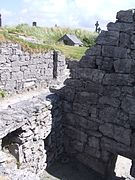
- O'Brien's Castle (NM 41.07)
- St. Cavan's Church(NM 41.08)
Demographics
The table below reports data on Inis Oírr's population taken from Discover the Islands of Ireland (Alex Ritsema, Collins Press, 1999) and the Census of Ireland. Census data in Ireland before 1841 are not considered complete and/or reliable.
|
|
| |||||||||||||||||||||||||||||||||||||||||||||||||||||||||||||||||||||||||||||||||||||||
| Source: Central Statistics Office. "CNA17: Population by Off Shore Island, Sex and Year". CSO.ie. Retrieved 12 October 2016. | |||||||||||||||||||||||||||||||||||||||||||||||||||||||||||||||||||||||||||||||||||||||||
Transport
The island is reached by ferry from Rossaveal in Connemara and Doolin in County Clare as well as from the other Aran Islands. There is also a regional airport on each island which is served from Connemara Regional Airport by AerArann. A pier was opened in Doolin in June 2015 for commercial ferries serving the island.[13] Islanders travel by foot or car around the island. Tourists can avail of tours/taxi trips by horse and trap.[citation needed]
Language
Irish is still today the daily language of the approximately 260 permanent residents.[citation needed] In addition, many school pupils from the mainland come to the island to learn Irish in an environment where it is a living language in the local college, Coláiste Laichtín during the months of June, July and August.
Sport
Some of the limestone sea cliffs have attracted interest from rock-climbers,[14] though the bigger islands of Inis Mór and Inis Meáin are more popular. Diving is possible.[15]
In the media
The island, including shots of the wrecked
Inisheer is also the name of a well-known slow air written by Thomas Walsh from Dublin, after a visit to the island in the 1970s.[17][18][19]
Inis Oírr was discussed at length in the work of
Gallery
-

-
 The lighthouse
 -
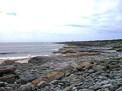 Eastern coastline
 -
 Saint Caomhan's church, viewed from the priest's residence in the west
 -
 Saint Caomhan's church with Caomhan's grave (Leaba Caomhan) in the background.
 -
 Saint Gobnait's church
 -
 Saint Fiachra's holy well near Cill Gobnait.
 -
 O'Brien fort near the summit of Inisheer. Northern and western elevations
 -
 View walking from pier towards beach / O'Brien's Castle
 -
 Áras Éanna, arts and cultural center
 -
 Tobar Éinne (Tobar Éanna), Saint Enda's holy well on Inis Oirr
 -
 O'Brien's Castle, built in the 14th century
 -
 The pier in 1991


References
- ^ a b "OSI Maps, 6" Cassini Maps". osi.ie. Ordnance Survey Ireland. Archived from the original on 6 July 2020. Retrieved 9 May 2022.
- ^ a b Population of Inhabited Islands Off the Coast (Report). Central Statistics Office. 2023. Retrieved 29 June 2023.
- ^ a b "Inis Oírr/Inisheer". Placenames Database of Ireland. (see scanned records)
- ^ Ó Murchú, Séamas. "An tainm áite Inis Oírr" in Éigse 26 (1992), pp. 119–123.
- ^ Éireann, Met. "Met Éireann - The Irish Weather Service". www.met.ie.
- JSTOR 20494847.
- ^ "Inis Oírr (Inisheer) Island".
- ^ "O'Brien's Castle". 2 May 2017.
- ^ "OBriens Castle Inis Oirr Aran Islands Ireland". Archived from the original on 30 March 2009.
- ^ a b "Double Take: The shipwreck on Inis Oirr that stars in Father Ted". thejournal.ie. Journal Media Ltd. 25 July 2018. Retrieved 24 November 2022.
- ^ a b "Irish ship wrecked off Galway Coast". The Irish Times. 9 March 1960. p. 1.
- ^ "Scotch on the rocks - Independent.ie".
- ^ "New Doolin Pier. Official blessing and opening ceremony. - Visit Doolin". 21 June 2015.
- ^ "Aran Islands - Irish Climbing Online Wiki". wiki.climbing.ie.
- ^ "Scuba diving ireland". Archived from the original on 17 May 2013. Retrieved 8 October 2013.
- ^ "The story behind Inis Oirr's Plassey Shipwreck". advertiser.ie. Galway Advertiser. 28 October 2020. Retrieved 24 November 2022.
- ^ Thoman Walsh Archived 28 May 2023 at the Wayback Machine, irishtunecomposers.weebly.com, retrieved 14 Aug. 2017
- ^ The tune Inisheer, thesession.org, retrieved 14. Aug. 2017
- ^ Inisheer, oh Inisheer; The Story of an Irish Air, www.folkworld.de, retrieved 14. Aug. 2017
- ISBN 9781483146256.
Inis Beag – a fictional name for Inisheer
- ^ Ó Giolláin, Diarmuid (2000). Locating Irish Folklore: Tradition, Modernity, Identity. Cork University Press. pp. 183.
inis beag inisheer -wikipedia.
External links
 Inis Oírr travel guide from Wikivoyage
- Official tourism website for Inis Oírr and the Aran Islands
