Jutulsessen

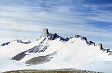
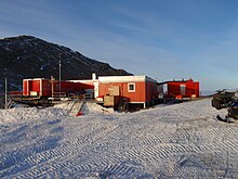
Jutulsessen is a nunatak in the Gjelsvik Mountains in Queen Maud Land, Antarctica. It is located in Princess Martha Coast, 235 kilometers (146 mi) from the King Haakon VII Sea. Jutulsessen is the site of the Norwegian research station Troll and the affiliated Troll Satellite Station, which has two radomes on top of the mountain. Troll Airfield is located in the vicinity.
Geography
Jutulsessen is a nunatak mountain with a peak 2,370 meters (7,780 ft)
The mountain area is horseshoe-shaped with a glacier and cirque of Sætet to the north. The two arms of the area are located northwards. The western arm is the location of Troll. The eastern arm is longer and consists of the narrow section of Jutulhogget and the wider Armlenet. Further north lies the isolated area of Stabben.[5] Blåfallet is an ice-depression on the western side of Knokane,[6] a ridge of Armlenet.[7] Jutuldalen is a valley in Armlenet,[8] with the ice-depression of Staupet to the west.[9] Armlenet also features the glacier of Ringfingerbreen.[10] Southeast of Sætet lies the broad valley of Brudgedalen,[11] and to the southeast lies the ridge of Brudga.[12] The three peaks closest to Troll are Trolltindane, the tallest of which is Trolltinden.
The area has a cold and dry climate being located in a desert. The annual mean temperature is −25 °C (−13 °F), with the summer temperature able to reach about 0 °C (32 °F) and the lowest during the winter at −50 °C (−58 °F). Storms, which can occur throughout the year, can occasionally make outdoor activity impossible. Being located south of the Antarctic Circle, Troll has midnight sun in the summer and polar night during the winter.[13]
History
The mountain was first photographed by the German Antarctic Expedition in 1938–39. It was subsequently mapped by Norwegian cartographers from surveys and air photographs taken during the Norwegian–British–Swedish Antarctic Expedition in 1949–52 and the subsequent Norwegian expedition in 1958–59. It was given the Norwegian name Jutulsessen, which means "the seat of the giant".[1]
Norway established the Antarctic polar station
Troll

The station took its name from the surrounding jagged mountains, which resemble
Research facilities include air and atmospheric measurement equipment operated by the
Important Bird Area

A 500 ha site some 6 km south-east of Troll Station has been designated an Important Bird Area (IBA) by BirdLife International, because it supports a large breeding colony of about 38,000 pairs of Antarctic petrels on north-facing slopes in the mountains. Snow petrels and south polar skuas also breed in the vicinity.[3]
References
- ^ a b "Jutulsessen Mountain". Geographic Names Information System. Retrieved 29 September 2012.
- ^ a b Kyvik (2008): 153
- ^ a b "Jutulsessen Mountain". BirdLife Data Zone. BirdLife International. 2015. Retrieved 11 November 2020.
- ^ a b c "Troll i ord - ord om Troll" (in Norwegian). Norwegian Polar Institute. Archived from the original on 5 April 2008. Retrieved 4 October 2010.
- ^ Elvevold, S. "Jutulsessens geologi" (in Norwegian). Norwegian Polar Institute. Archived from the original on 23 February 2013. Retrieved 29 September 2012.
- ^ "Blåfallet". Norwegian Polar Institute. Retrieved 29 September 2012.
- ^ "Knokane". Norwegian Polar Institute. Retrieved 29 September 2012.
- ^ "Jutuldalen". Norwegian Polar Institute. Retrieved 29 September 2012.
- ^ "Staupet". Norwegian Polar Institute. Retrieved 29 September 2012.
- ^ "Ringfingerbreen". Norwegian Polar Institute. Retrieved 29 September 2012.
- ^ "Brugdedalen". Norwegian Polar Institute. Retrieved 29 September 2012.
- ^ "Brugda". Norwegian Polar Institute. Retrieved 29 September 2012.
- ^ Hustadnes, John. "Troll". Archived from the original on 7 July 2010. Retrieved 4 October 2010.
- ^ Wormdal (2011): 108
- ^ Kyvik (2008): 169
- ^ Kyvik (2008): 155
- ISBN 978-1-74104-549-9.
- ^ Solholm, Rolleiv (1 February 2003). "New Norwegian air field in the Antarctic". The Norway Post. Archived from the original on 7 August 2011. Retrieved 23 May 2010.
- ^ "Antarktis: Troll får nye krefter". Norwegian Institute for Air Research. Archived from the original on 7 July 2010. Retrieved 4 October 2010.
- ^ "TrollSat/Antarctica". Kongsberg Satellite Services. Archived from the original on 7 July 2010. Retrieved 4 October 2010.
- ^ "Troll". Norwegian Meteorological Institute. Archived from the original on 7 July 2010. Retrieved 4 October 2010.
Bibliography
- Kyvik, Helga, ed. (2008). Norge i Antarktis (in Norwegian). Oslo: Schibsted Forlag. ISBN 978-82-516-2589-0.
- Wormdal, Bård (2011). Satellittkrigen (in Norwegian). Oslo: Pax. ISBN 978-82-530-3450-8.
