Byers Peninsula

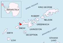
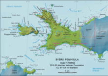
Byers Peninsula is a mainly ice-free peninsula forming the west end of Livingston Island in the South Shetland Islands of Antarctica. It occupies 60 km2 (23 sq mi),[1] borders Ivanov Beach to the northeast and is separated from Rotch Dome on the east by the ridge of Urvich Wall. The peninsula features more than 60 meltwater streams and as many lakes, notably Midge Lake, Limnopolar Lake and Basalt Lake.[2] Byers Peninsula has a regime of special environmental protection under the Antarctic Treaty System and requires a permit to enter.[3]
History
The feature was named by the
Antarctic Specially Protected Area


The peninsula has been designated an
The eastern boundary of the protected area was shifted eastwards to 60º53'45"W in 2016 to include besides Byers Peninsula also all ice-free ground and ice sheet west of Clark Nunatak and Rowe Point, increasing the overall surface area of the protected territory to 84.7 km2 (32.7 sq mi).[5] Excepting Vardim Rocks, no offshore islets or rocks are protected. In particular, Rugged Island, Window Island and Astor Island are not protected.
Two restricted zones in the protected territory that are of scientific importance to Antarctic microbiology have been further designated with greater restriction placed on access with the aim of preventing microbial or other contamination by human activity: Ray Promontory in the west, and northwestern Rotch Dome, northern Urvich Wall Ridge and adjacent deglaciated ground on Ivanov Beach in the east.[5]
Important Bird Area
The protected territory ASPA 126 Byers Peninsula has been identified as an Important Bird Area (IBA) by BirdLife International because it supports breeding colonies of Antarctic terns (1760 pairs) and kelp gulls (450 pairs). Other birds nesting on the peninsula include chinstrap and gentoo penguins, Wilson's and black-bellied storm petrels, Cape petrels, southern giant petrels, imperial shags, brown skuas and snowy sheathbills. Large numbers of southern elephant seals haul out during their breeding season.[6]
See also
Maps

- Chart of South Shetland including Coronation Island, &c. from the exploration of the sloop Dove in the years 1821 and 1822 by George Powell Commander of the same. Scale ca. 1:200000. London: Laurie, 1822.
- Península Byers, Isla Livingston. Mapa topográfico a escala 1:25000. Madrid: Servicio Geográfico del Ejército, 1992. (Map image on p. 55 of the linked study)
- L.L. Ivanov et al. Antarctica: Livingston Island and Greenwich Island, South Shetland Islands. Scale 1:100000 topographic map. Sofia: Antarctic Place-names Commission of Bulgaria, 2005.
- L.L. Ivanov. ISBN 978-954-92032-6-4)
- South Shetland Islands: Livingston Island, Byers Peninsula. Scale 1:50000 satellite map. UK Antarctic Place-names Committee, 2010.
- Antarctic Digital Database (ADD). Scale 1:250000 topographic map of Antarctica. Scientific Committee on Antarctic Research (SCAR). Since 1993, regularly updated.
- L.L. Ivanov. ISBN 978-619-90008-3-0
In fiction
Byers Peninsula is part of the mise-en-scène in the Antarctica
Notes
- ISBN 978-954-92032-6-4)
- ^ ISBN 978-954-07-3939-7
- ^ Management Plan for Antarctic Specially Protected Area No. 126 Byers Peninsula, Livingston Island, South Shetland Islands. Archived 2010-07-06 at the Wayback Machine SCAR Bulletin 150, July 2003.
- ^ "Byers Peninsula, Livingston Island, South Shetland Islands" (PDF). Management Plan for Antarctic Specially Protected Area No. 126: Measure 1. Antarctic Treaty Secretariat. 2002. Retrieved 2013-10-02.
- ^ a b Management Plan for Antarctic Specially Protected Area No. 126 Byers Peninsula. Measure 4 (2016), ATCM XXXIX Final Report. Santiago, 2016.
- ^ Byers Peninsula, Livingston Island. BirdLife data zone: Important Bird Areas. BirdLife International, 2019
- ISBN 978-0-7278-8639-2
- ^ The Killing Ship. Susanna Gregory Website, 2019
References
- Byers Peninsula. SCAR Composite Antarctic Gazetteer
 This article incorporates public domain material from "Byers Peninsula". Geographic Names Information System. United States Geological Survey.
