
Kennebecasis River
This article needs additional citations for verification. (December 2009) |
| Kennebecasis River | |
|---|---|
 Kennebecasis River | |
| Location | |
| Country | Canada |
| Province | New Brunswick |
| Physical characteristics | |
| Source | |
| • location | Rothesay, Quispamsis |
St. John River) | |
• coordinates | 45°19′0″N 66°8′0″W / 45.31667°N 66.13333°W |
• elevation | 50 m (160 ft) |
| Length | 95 km (59 mi) |
| Basin size | 1,346 square kilometres (134,600 ha) |
The Kennebecasis River (/kɛnəbəˈkeɪsɪs/ ken-ə-bə-KAY-sis) is a tributary of the Saint John River in southern New Brunswick, Canada. The name Kennebecasis is thought to be derived from the Mi'kmaq "Kenepekachiachk", meaning "little long bay place."[citation needed] It runs for approximately 95 kilometres, draining an area in the Caledonia Highlands, an extension of the Appalachian Mountains, inland from the Bay of Fundy.[1]
Description
The river's source is in the foothills of
Between
The upper two thirds of the Kennebecasis River passes through pastoral rural countryside consisting of Acadian mixed forest and various agricultural areas, notably dairy farms around Sussex. Southwest of Sussex, the river becomes increasingly larger as it passes the communities of Valley Waters and Hampton, before it empties into a delta-like area informally called the Hampton Marsh. West of Hampton, the Kennebecasis flows in a broad fjord-like glacial valley which defines the southern side of the Kingston Peninsula. At its junction with the Saint John River, the Kennebecasis River helps to form Grand Bay.
Several large islands can be found in the river, such as
Hampton Marsh
-
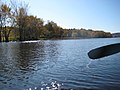 The river widens as it flows through the Hampton Marsh.
 -
 High water in the Hampton Marsh in April 2008.
 -
 The same area in June 2008, demonstrating the difference in water level.
 -
 The lower end of the Hampton Marsh looking across to Darlings Island.


Lower Kennebecasis River valley
The communities of
"The Valley" or "KV", as the lower Kennebecasis River valley is called by locals, has experienced dramatic population growth over the past several decades, largely owing to the development of Route 1 through the area in the 1960s. Once a minor dormitory suburb of the Saint John area, the towns of Rothesay and Quispamsis constitute a moderately-sized population centre with some commercial development. Saint John, by contrast, has suffered from an erosion of its tax and commercial bases as population and businesses have migrated away from the urban core.
The Kennebecasis effectively isolates the
The Kennebecasis River valley communities have rich histories; many were settled by Loyalists in the 1780s and 1790s who traveled upriver from Saint John to land grants offered by the British government. They became more prominent during the late 1800s following construction of the European and North American Railway through the area, which allowed for easier travel between Saint John and Moncton. Over the ensuing decades, the lower Kennebecasis River valley became a summer vacation destination for wealthy Maritimers, Americans and central Canadians. It is also a popular cruising destination for recreational boating as a result of its connection with the navigable portions of the Saint John River.
See also
References
- ^ Kennebecasis Watershed, Kennebecasis Watershed Restoration Committee
External links
| Rivers | |
|---|---|
| Towns | |
| Neighbourhoods |
|
| Islands | |
| Education | |
| River crossings | |
| Electoral districts | |
| Other | |