
Kish (Sumer)
Babil Governorate, Iraq | |
| Region | Mesopotamia |
|---|---|
| Coordinates | 32°32′25″N 44°36′17″E / 32.54028°N 44.60472°E |
| Type | Settlement |
| History | |
| Founded | Ubaid period |
| Periods | Ubaid to Hellenistic |
| Site notes | |
| Excavation dates | 1852, 1912, 1923–1933, 1989, 2000–2001 |
| Archaeologists | Austen Henry Layard, Julius Oppert, Henri de Genouillac, Stephen Langdon, Hideo Fuji, Ken Matsumoto |
Kish (
History
.svg)
Kish was occupied from the Ubaid period (c.5300–4300 BC), gaining prominence as one of the pre-eminent powers in the region during the Early Dynastic Period when it reached its maximum extent of 230 hectares.[7][8]
3rd Millennium BC
The
Of the twenty-first king of Kish on the list,
.Some early kings of Kish are known through archaeology, but are not named on the King list. It can be difficult to determine if these are actually rulers of Kish or had merely adopted the common appellation "King of Kish". This includes Mesilim, who built temples in Adab and Lagash, where he seems to have exercised some control. Two other examples were the sleeve of an Early Dynatic II bronze sword found at Girsu which read "Lugal-namni[r]-sum (is) king of Kis" and a statue fragment found at Nippur which read "Enna-il, king of Kis".[4][13]
.jpg)
After its early supremacy, Kish declined economically and militarily, but retained a strong political and symbolic significance.[16] Its influence reached as far west as the city of Ebla near the Mediterranean Sea, as shown by the Ebla tablets.[17][18] According to the Ebla tablets, Kish was defeated in the time of Ebla ruler Ishar-Damu, probably by Uruk. Shortly afterward KIsh joined Ebla in defeating Mari, followed by the marriage of the Eblan princess Keshdut to a king of Kish.[19] Just as with Nippur to the south, control of Kish was a prime element in legitimizing dominance over the north of Mesopotamia. Because of the city's symbolic value, strong rulers later claimed the traditional title "King of Kish", even if they were from Akkad, Ur, Assyria, Isin, Larsa or Babylon.[20] One of the earliest to adopt this title upon subjecting Kish to his empire was King Mesannepada of Ur.[21]

Old Babylonian period
By the early part of the
At some period or periods within the Old Babylonian period, Kish was under the control of a series of rulers generally called the "Manana Dynasty". Most of what is known comes from two illicitly excavated archive thought to be from the town of Damrum, near Kish.[23][24] These rulers include Iawian, Halium, Abdi-Erah, Manana, and four others. Several year names of Iawium are known including "Year Sumu-ditana died". Samsu-Ditana was the last ruler of the First Dynasty of Babylon.[25] One ruler, Ashduniarim is known from a long inscription on a clay foundation cone found at Kish.
"Ašdũni-iarīm, the mighty man, beloved of Ištar, favored by Zababa, king of Kiš, when the world quarters four became hostile to me, for eight years battle I waged, and in the eighth year my opponent to clay indeed turned. ... "[26]
Later history
The succeeding
After the
Archaeology
Kish is located 12 km (7.5 mi) east of the ancient city of
._The_ruling_city_immediately_after_the_deluge._The_ancient_ruins_showing_extensive_remains_LOC_matpc.16176.jpg)
After irregularly excavated tablets began appearing at the beginning of the twentieth century,
Later, a joint
A surface survey of Kish and the area around it was conducted in 1966–1967. It showed that there were villages at Uhaimir and Ingharra in the Ubaid and Protoliterate periods. These expanded into two cites in ED I and reached a peak in Ed III with Ingharra becoming the larger city at that time. The site was lightly occupied in the Akkadian period with modest towns on Ingharra and Mound W. During Ur III, Isin-Larsa, and Old Babylonian times there was a revival mostly centered around Uhaimir. The later half of the 2nd millennium BC showed light occupation, all on Mound W. In the Neo-Babylonian period the rivercourse shifted from north to west, with Uhaimir having a large temple with associated fort, a major temple on Ingharra, and a major town on Mound W. The Achaemenid/Seleucid settlement was limited to the western end of Uhaimir. The Parthian and Sassanian periods showed light occupation, except for Tell Bandar.[10] As part of this survey soundings were made at Umm-el-Jir (the site named Umm el-Jerab that Oriental Institute had found Old Akkadian tablets in 1932) 27 kilometers from Kish.[45]
More recently, a Japanese team from the Kokushikan University led by Hideo Fuji and Ken Matsumoto excavated at Tell Uhaimir in 1989–89, 2000, and 2001. The final season lasted only one week. Work was focused mainly on Tell A with some time spent at the plano-convex building.[46][47][48]
In the Chicago expedition to Kish in 1923–1933, several other sections are included:
- Tell Ingharra – Twin ziggurats and Neo-Babylonian Temple Complex.
- Area P: Located in the Northern part of Kish which the Plano-convex Building resided
- Mound A, which includes a palace and a cemetery
- Tell H, identified roughly as "The Sasanian Settlement"[36]
Tell Uhaimir
This site consists of three subtells (T, X, and Z). Tell Z was the location of one of the main ziggurats and where temples had been built and rebuilt from the Old Babylonian to the Neo-Babylonian periods. At Tell X a 1st Millennium BC fort was uncovered and at Tell T some Old Babylonian structures were found. Between Uhaimir and Ingharra are three smaller tells and further east Tell W where Neo-Assyrian tablets as well as an entire Neo-Babylonian archive was found consisting of about 1000 tablets.
Tell Ingharra


Located in the eastern side of the ancient Kish, Tell Ingharra was extensively explored during the Chicago excavation and provided the best known archaeological sequence in the 3rd millennium BC site. The site consists of several subtells (A, B, D, E, F, G, H, and Tell Bandar which is made up of Tells C and V).[49][50] In particular, the 1923 excavation concentrated heavily on mound E with its twin ziggurats, while the roughly 130 meter square Neo-Babylonian temple, built on an Early Dynastic plano-copnvex platform, was one of the two buildings that was properly described in a published report.[36]
The twin ziggurats were built of small plano-convex bricks in a herringbone fashion on the summit of Tell Ingharra. The larger one is located on the south-west side of the temple and the smaller one on the south-east side.[36] The excavation report mainly focused on the larger ziggurat while there had been only one report on the smaller one by Mackay. Based on the findings from the larger ziggurat, it is suggested that the structures were built at the end of the Early Dynastic IIIa period to commemorate the city.[49] The fascination of the ziggurats was interesting to the excavators as it was the only Early Dynastic structure that was not destroyed or obscured by later reconstructions, which was why it provided valuable evidence of that time period.[36]
As for the temple complex, the findings of the temple had determined that the mound was part of the city of Hursagkalama. It was used as an active religious centre until after 482 BC. They also had identified the builder as Nabonidus or Nebuchadnezzar II based on the bricks with inscriptions and barrel cylinder fragments reported in the temple.[36]
An Early Dynastic I/IIIa cemetery extended to the south towards Mound A with a number of high status graves containing multiple burials and carts drawn by equids or bovids and are considered as predecessors to the royal burials at Ur.[51]
Area P
.png)
This area, north of tell W, was unearthed during the second excavation season (1923–1924) led by Mackay, which uncovered the 'Plano-convex building' (PCB).[52][53] But outstanding discoveries in Palace A rapidly overshadowed the contemporary excavation here, and the building remained partially uncovered.[52]
Revealed by its stratigraphy and pottery assemblage was the existence of three distinct architectural phases.[52] The earliest archaeological occupation dates back to the ED II period.[52] Above it, rested the massive ED III construction – the PCB. Multiple rooms in the PCB exhibited layers of ashes and charcoals with arrowheads and copper blades, attested that the PCB suffered significant destruction twice during the late ED III period.[53] After its destruction, the PCB was abandoned.[8][52][53] Located above later floors of the PCB were scattered burials during the Akkadian period.[46][53]
The 'Plano-convex building'
.png)
The Plano-convex building was a fortified construction built extensively with
- Sector A: Production area
- Sector B: Inconclusive but arguably an administration area
- Sector C: Unknown but exhibit a high degree of segregation
- Sector D: Private, domestic area for housing activities
Mound A
Mound A, which includes a cemetery and an Early Dynastic III palace, was discovered during 1922–1925 excavations conducted by Ernest Mackay, under the Field Museum and Oxford University.[54][50] Although it was earlier a part of the Ingharra mounds lying about 70 meters to the north, it is now separated by an alluvial valley. The seals and other artifacts found in the graves, dating back to a later age than the palace, show that the site was used as a cemetery from the end of the Early Dynastic period until the early Akkadian Empire period.[55][54][56][57][58]
The Sumerian Palace
The palace, which was unearthed beneath the mound, had fallen into decay and was used as a burial ground during Early Dynastic III. It comprises three sections – the original building, the eastern wing and stairway, and the annex. The original building, which was composed of unbaked plano-convex bricks (23 × 15 × 3.5–6 cm), had extremely thick walls, while the annex, which was added later to the south of the building, had comparatively thinner walls. A 2.30 m wide passage was constructed within the outer wall of the original building to prevent invaders from entering the structure.[59]
The archaeological findings within the palace lack pottery items, the most remarkable among them was a fragment of slate and limestone inlay work, which represents the scene of a king punishing a prisoner.[59]
_(View_2).png)
_(View_1).png)
Tell H

In the 1923–1933 Expedition, Tell H became the focus of its final three seasons (1930–1933). Due to personal reasons of the excavators, the Kish material in this section remained selective, mainly yielding Sasanian pottery, coins, incantation bowls and so on.[36][37] The dating of this section crossed a range of periods, with layer upon layer built on the site. Evidence shows that in the Early Dynastic III Period, there once even existed a twin city.[8] Therefore, the city occupies a relatively unsettled presence in chronology. But from the excavation, eight buildings were identified as from the Sasanian period, thus making this place primarily identified as the Sasanian Settlement. Researchers suspect that some of the buildings might function together as a complex serving different purposes, including royal residence, storage, and administration.[36]

The most prominent finding is the stucco decoration in the first two buildings, while the 1923–1933 team also figured out the floor plan and architectural structure of others. It was partly through these stucco decorations that researchers identified the royal resident to be Bahram V (420–438 AD)—Sasanian kings had their distinctive crowns separately, and the unique crown pattern on stucco served as evidence to support this argument. In Kish, which once functioned as a transfer station between Ctesiphon and Hira, Bahram V built palaces for summer entertainment, which explains why one of the buildings has a huge water tank in the middle, probably functioning to cool down the court in summers. Around Bahram V's palaces, a group of Sasanian people also took residence and developed a system of settlement and commercial activities.[36]
Gallery
-
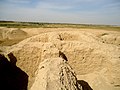
 Ruins of a ziggurat at the Sumerian city of Kish. Babel Governorate, Iraq.
 -
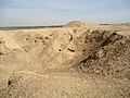
 An ancient mound at Kish, Babel Governorate, Iraq
 -
 An ancient mound at the city of Kish, Mesopotamia, Babel Governorate, Iraq
 -
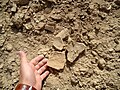 Pottery fragments, illegal exavations at the ancient city of Kish, Tell al-Uhaymir, Iraq
 -
 Ancient mound at the city of Kish, Mesopotamia, Babil Governorate, Iraq
 -
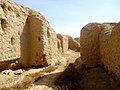 Ruins near the ziggurat of Kish at Tell al-Uhaymir, Mesopotamia, Babel Governorate, Iraq
 -
 Ruins near the ziggurat of Kish, Tell al-Uhaymir, Babylon Governorate, Iraq
 -
 Ruins near the ziggurat of the city of Kish at Tell al-Uhaymir, Babel Governorate, Iraq
 -
 Ruins of the ziggurat of the ancient city of Kish, Tell al-Uhaymir, Mesopotamia, Iraq
 -
![Indus Valley civilisation "Unicorn" seal excavated in Kish, early Sumerian period, c. 3000 BC. An example of ancient Indus-Mesopotamia relations.[60]](//upload.wikimedia.org/wikipedia/commons/thumb/d/dc/Indus_seal_excavated_in_Kish%2C_Mesopotamia%2C_early_Sumerian_period.jpg/120px-Indus_seal_excavated_in_Kish%2C_Mesopotamia%2C_early_Sumerian_period.jpg) Indus-Mesopotamia relations.[60]
Indus-Mesopotamia relations.[60]


![Indus Valley civilisation "Unicorn" seal excavated in Kish, early Sumerian period, c. 3000 BC. An example of ancient Indus-Mesopotamia relations.[60]](/File:Indus_seal_excavated_in_Kish,_Mesopotamia,_early_Sumerian_period.jpg)
See also
- Cities of the Ancient Near East
- Short chronology timeline
Notes
- ^ The Electronic Text Corpus of Sumerian Literature
- ^ Electronic Pennsylvania Sumerian Dictionary (EPSD)
- ^ wparkinson (2011-01-11). "The Kish Collection". Field Museum. Retrieved 2020-08-20.
- ^ ISBN 9780802035868
- ^ Inanna's Descent to the Underworld translation at ETCSL
- ^ McEwan, G. J. P., "Late Babylonian Kish", Iraq, vol. 45, no. 1, pp. 117–23, 1983
- ^ Weiss, Harvey, and Mcguire Gibson. "Kish, Akkad and Agade." Journal of the American Oriental Society, vol. 95, no. 3, 1975, p. 434., doi:10.2307/599355.
- ^ ISBN 978-1-61491-063-3
- ^ [2] Thorkild Jacobsen, "The Sumerian King List", Assyriological Studies 11, Chicago: University of Chricago Press, 1939
- ^ a b c d e f [3] Gibson, McGuire, "The City and Area of Kish", Coconut Grove, Miami, Florida, Field Research Projects, 1972
- ^ I. J. Gelb, "Mari and the Kish Civilization", in Mari in Retrospect: Fifty Years of Mari and Mari Studies (ed. Gordon D. Young), Winona Lake, IN: Eisenbrauns, 1992
- ISBN 9789004445215. Retrieved 23 February 2022.
- ISBN 9780802035868
- ^ a b Hall, H. R. (Harry Reginald); Woolley, Leonard; Legrain, Leon (1900). Ur excavations. Trustees of the Two Museums by the aid of a grant from the Carnegie Corporation of New York. p. 312.
- ^ Image of a Mesanepada seal in: Legrain, Léon (1936). Ur Excavations Voulme III Arachaic Seal-impressions (PDF). The Trustees Of The Two Museums By The Aid Of A Grant From The Carnegi Corporation Of New York. p. 44 seal 518 for description, Plate 30, seal 518 for image.
- ^ [4] Steinkeller, Piotr., "An Archaic 'Prisoner Plaque' From Kiš.", Revue d'Assyriologie et d'archéologie Orientale, vol. 107, pp. 131–57, 2013
- ^ Archi, Alfonso., "More on Ebla and Kiš", in Ebla and Its Archives: Texts, History, and Society, Berlin, München, Boston: De Gruyter, pp. 478-496, 2015
- ^ Moorey, P. R. S., "Abu Salabikh, Kish, Mari and Ebla: Mid-Third Millennium Archaeological Interconnections.", American Journal of Archaeology, vol. 85, no. 4, pp. 447–48, 1981
- ^ Archi, Alfonso, and Maria Giovanna Biga, "A Victory over Mari and the Fall of Ebla", Journal of Cuneiform Studies 55: 1–44, 2003
- ^ Maeda, T., "'King of Kish' in Pre-Sargonic Sumer", Orient 17, pp. 1–17, 1981
- ^ Albrecht Goetze, "Early Kings of Kish", Journal of Cuneiform Studies, vol. 15, no. 3, pp. 105–111, 1961
- ^ L. W. King, "Chronicles Concerning Early Babylonian Kings", II, London, pp. 87–96, 1907
- ^ de Boer, Rients, "Two early Old Babylonian "Mananâ" archives dated to the last years of Sumu-la-El", Revue d’Assyriologie et d’archéologie Orientale, vol. 111, pp. 25–64, 2017
- ^ Simmons, Stephen D., "Early Old Babylonian Tablets from Harmal and Elsewhere (Continued)", Journal of Cuneiform Studies, vol. 14, no. 3, pp. 75–87, 1960
- ^ Yuhong, Wu, and Stephanie Dalley, "The Origins of the Manana Dynasty at Kish, and the Assyrian King List", Iraq, vol. 52, pp. 159–65, 1990
- ^ “RIME 4.08.01.01 Composite Artifact Entry.” 2013. Cuneiform Digital Library Initiative (CDLI). January 20, 2013. https://cdli.ucla.edu/P448588.
- ^ T. Claydon, "Kish in the Kassite Period (c. 1650 – 1150 B.C)", Iraq, vol. 54, pp. 141–155, 1992
- ISBN 978-0-903472-28-9
- ^ Tureau-Dangin, F., "Asduni-Erim, roi de kis", Revue d'Assyriologie 8, pp. 65–79, 1909
- ^ Henri de Genouillac, "Premières recherches archéologiques à Kich : mission d'Henri de Genouillac 1911–1912 : rapport sur les travaux et inventaires, fac-similés, dessins, photographies et plans. Tome premier", Paris : Libr. ancienne Edouard Champion, 5, quai Malaquais, 1924
- ^ Henri de Genouillac, "Fouilles françaises d'El-Akhymer", Champion, 1924–25
- ^ Stephen Langdon, "Excavations at Kish I (1923–1924)", 1924
- ^ Stephen Langdon and L. C. Watelin, "Excavations at Kish III (1925–1927)", 1930
- ^ Stephen Langdon and L. C. Watelin, "Excavations at Kish IV (1925–1930)", 1934
- ^ [6] Henry Field, "The Field Museum-Oxford University expedition to Kish, Mesopotamia, 1923–1929", Chicago, Field Museum of Natural History, 1929
- ^ ISBN 0-19-813191-7
- ^ a b S. Langdon and D. B. Harden, "Excavations at Kish and Barghuthiat 1933", Iraq, vol. 1, no. 2, pp. 113–136, 1934
- ^ S. D. Ross, "The excavations at Kish. With special reference to the conclusions reached in 1928–29", in Journal of the Royal Central Asian Society, vol. 17, iss. 3, pp. 291–300, 1930
- ^ Henry Field, "Ancient Wheat and Barley from Kish Mesopotamia", American Anthropologist, New Series, vol. 34, no. 2, pp. 303–309, 1932
- ^ L. H. Dudley Buxton and D. Talbot Rice, "Report on the Human Remains Found at Kish", The Journal of the Royal Anthropological Institute of Great Britain and Ireland, vol. 61, pp. 57–119, 1931
- ^ Davies, D. C., "Unearthing the Past at Kish.", Scientific American, vol. 138, no. 3, pp. 216–18, 1928
- ISBN 978-1-61491-092-3
- ISBN 978-1-61491-092-3
- ^ Zaina, F., A Radiocarbon date from Early Dynastic Kish and the Stratigraphy and Chronology of the YWN sounding at Tell Ingharra, Iraq, vol. 77(1), pp. 225–234, 2015
- ^ Gibson, McGuire, "Umm El-Jīr, a Town in Akkad", Journal of Near Eastern Studies, vol. 31, no. 4, pp. 237–94, 1972
- ^ a b K. Matsumoto, "Preliminary Report on the Excavations at Kish/Hursagkalama 1988–1989", al-Rāfidān 12, pp. 261-307, 1991
- ^ K. Matsumoto and H. Oguchi, "Excavations at Kish, 2000", al-Rāfidān, vol. 23, pp. 1–16, 2002
- ^ K. Matsumoto and H. Oguchi, "News from Kish: The 2001 Japanese Work" al-Rafidan, vol. 25, pp. 1–8, 2004
- ^ a b Zaina, Federico (April 2016). "Tell Ingharra-East Kish in the 3rd Millennium BC: Urban Development Architecture and Functional Analysis". Proceedings of the 9th International Congress on the Archaeology of the Ancient Near East. 1: 431.
- ^ ISBN 978-88-7849-149-6.)
{{cite book}}: CS1 maint: numeric names: authors list (link - ISBN 978-1-61491-092-3
- ^ a b c d e f P. R. S. Moorey, "The 'Plano-Convex Building' at Kish and Early Mesopotamian Palaces", Iraq, vol. 26, no. 2, pp. 83–98, 1964
- ^ a b c d e f g h i [11] Zaina, F., "Craft, Administration and Power in Early Dynastic Mesopotamian Public Buildings. Recovering the Plano-convex Building at Kish", Iraq, Paléorient, vol. 41, pp. 177–197, 2015
- ^ a b [12] E. Mackay, "Report on the excavation of the 'A' Cemetery at Kish, Mesopotamia: Part I." Anthropology, Memoirs, vol. 1, no. 1, Chicago: Field Museum, 1925
- ^ Torres-Rouff, Christina, William J. Pestle, and Blair M. Daverman, "Commemorating Bodies and Lives at Kish’s ‘A Cemetery’: (Re)presenting So-cial Memory", Journal of Social Archaeology, 12, pp. 193–219, 2012
- ^ Whelan, E., "Dating the A Cemetery at kish: A reconsideration", JFA 5, pp. 79–96, 1978
- ^ Hrouda, B. and karstens, k., "Zur inneren Chronologie des Friedhofes „ A „ .... bei kig", Zeitschrift für Assyriologie undvorderasiatische Archäologie 24, pp. 256–267, 1966
- ^ Breniquet, C., "Le cimetière 'A' de kish. Essai d 'interprétation", Iraq 46, pp. 19–28, 1984
- ^ a b [13] E. Mackay, "A Sumerian Palace and the "A" Cemetery: Part 2", Anthropology Memoirs, vol. 1, no. 2, Chicago: Field Museum, 1929
- JSTOR 25220818.
Further reading
- Algaze, G., "Private Houses and Graves at Ingharra. A Reconsideration", Mesopotamia 18–19, pp. 135–195, 1983–84
- Charvat, Petr, "The Kish Evidence and the Emergence of States in Mesopotamia."., Current Anthropology, vol. 22, no. 6, pp. 686–88, 1981
- Charvat, Petr, "Earliest History of the Kingdom of Kiš", P. Charvát and P.M. Vlčková (eds.), Who Was King? Who Was Not King? The Rulers and the Ruled in the Ancient Near East, Institute of Archaeology of the Academy of Sciences, Prague, pp. 16–23, 2010
- [14] I. J. Gelb, "Sargonic Texts in the Ashmolean Museum, Oxford", Materials for the Assyrian Dictionary 5, University of Chicago Press, 1970 ISBN 0-226-62309-2
- McGuire Gibson, "The Archaeological uses of Cuneiform Documents: Patterns of Occupation at the City of Kish", Iraq, vol. 34, iss. 2, pp. 113–123, Autumn 1972
- Harper, Prudence O., "Tomorrow We Dig! Excerpts from Vaughn E. Crawford’s Letters and Newsletters from al-Hiba", in Leaving No Stones Unturned: Essays on the Ancient Near East and Egypt in Honor of Donald P. Hansen, edited by Erica Ehrenberg, University Park, USA: Penn State University Press, pp. 89–102, 2002
- Harden, D.B, "A Typological Examination of Sumerian Pottery from Jamdat Nasr and kish.", Iraq 1, pp. 30–44, 1934
- Langdon, S.H., "Tablets from Kiš", Proceedings of the Society of Babylonian Archaeology, vol. 33, pp. 185–96, 232–42, 1911
- Molleson, Theya, and Joel Blondiaux., "Riders' bones from Kish, Iraq.", Cambridge Archaeological Journal 4.2, pp. 312–316, 1994
- P. R. S. Moorey, "A Re-Consideration of the Excavations on Tell Ingharra (East Kish) 1923-33", Iraq, vol. 28, no. 1, pp. 18–51, 1966
- P. R. S. Moorey, "The Terracotta Plaques from Kish and Hursagkalama, c. 1850 to 1650 B.C.", Iraq, vol. 37, no. 2, pp. 79–99, 1975
- P. R. S. Moorey, "Kish Excavation 1923–1933", Oxford: Oxford Press, 1978 ISBN 9780198131915
- P. R. S. Moorey, "Cemetery A at Kish: Grave Groups and Chronology", Iraq, vol. 32, no. 2, pp. 86–128, 1970
- Nissen, Hans "The early history of the ancient Near East, 9000–2000 B.C." Chicago/London: ISBN 0-226-58658-8) Elizabeth Lutzeir, trans.
- Sa'di al-Ruwayshdi, "A Comparison Between the Palace at Kish and Later Palaces", vol. 30, no. 1–2, pp. 47–49, 1974
- Watelin, L.Ch., "Rapport sur les Fouilles de kish", Journal Asiatique 215, pp. 103–116, 1929
- Watelin, L.Ch., "Note sur l'Industrie Lithique de kish", L'Anthropologie 39, pp. 65–76, 1929
- Weiss, Harvey, and Mcguire Gibson., "Kish, Akkad and Agade.", Journal of the American Oriental Society, vol. 95, no. 3, pp. 434–453, 1975, doi:10.2307/599355.
- Yoffee, Norman, "Towards a Biography of Kish: Notes on Urbanism and Comparison", in Literature as Politics, Politics as Literature: Essays on the Ancient Near East in Honor of Peter Machinist, edited by David S. Vanderhooft and Abraham Winitzer, University Park, USA: Penn State University Press, pp. 527–544, 2013
- [15] Norman Yoffee, "The Economics of Ritual at Late Old Babylonian Kish", Journal of the Economic and Social History of the Orient, vol. 41, no. 3, pp. 312–343, 1998
External links
- Early Dynastic "prisoner plaque" from Kish (Uhaimir) at CDLI
- Online Kish Collection at the Field Museum
- Field Museum 'reuniting' scattered collections from ancient Iraq site - ScienceDaily - 25-Oct-2004
- YouTube video on Field Museum Kish effort
- Kish Site photographs at Oriental Institute of Chicago
| National | |
|---|---|
| Geographic | |