
Lichtervelde
Lichtervelde | ||
|---|---|---|
 Town hall of Lichtervelde | ||
 Flag  Coat of arms | ||
Location of Lichtervelde  | ||
 Lichtervelde Location in Belgium
Location of Lichtervelde in West Flanders Region Flemish Region | | |
| Province | West Flanders | |
| Arrondissement | Roeselare | |
| Government | ||
| • Mayor | Ria Beeusaert-Pattyn | |
| • Governing party/ies | CD&V | |
| Area | ||
| • Total | 26.16 km2 (10.10 sq mi) | |
| Population (2018-01-01)[1] | ||
| • Total | 8,793 | |
| • Density | 340/km2 (870/sq mi) | |
| Postal codes | 8810 | |
| NIS code | 36011 | |
| Area codes | 051 | |
| Website | www.lichtervelde.be | |
Lichtervelde (Dutch pronunciation: [ˈlɪxtərˌvɛldə]) is a municipality located in the Belgian province of West Flanders. The municipality comprises only the town of Lichtervelde. On January 1, 2006 Lichtervelde had a total population of 8,400. The total area is 25.93 km² which gives a population density of 324 inhabitants per km². The church is 64 m high. In this town the inventor Charles Joseph Van Depoele was born.
-
 Market Place and Sint-Jacobus church
 -
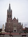 Sint-Jacobus church
 -
 Gustaaf Colpaert, mayor 1927-1932
 -
 The railway station beginning 20th Century postcard
 -
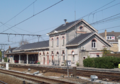 Lichtervelde station of NMBS


.png)
References
- ^ "Wettelijke Bevolking per gemeente op 1 januari 2018". Statbel. Retrieved 9 March 2019.
External links
 Media related to Lichtervelde at Wikimedia Commons
- Official website - Available only in Dutch
Places adjacent to Lichtervelde | |
|---|---|
| Bruges |  | |
|---|---|---|
| Diksmuide | ||
| Kortrijk | ||
| Ostend | ||
| Roeselare | ||
| Tielt | ||
| Veurne | ||
| Ypres | ||
| ||
| International | |
|---|---|
| Geographic | |
| Other | |
This West Flanders location article is a stub. You can help Wikipedia by expanding it. |