
Nieuwpoort, Belgium
Nieuwpoort
Nieuwpôort ( West Flemish) Nieuport (French) | ||
|---|---|---|
City and municipality | ||
.jpg) Belfry and city hall | ||
_vlag.svg) Flag _wapen.svg) Coat of arms | ||
Location of Nieuwpoort  | ||
 Nieuwpoort Location in Belgium
Location of Nieuwpoort in West Flanders Region Flemish Region | | |
| Province | West Flanders | |
| Arrondissement | Veurne | |
| Government | ||
| • Mayor | Geert Vanden Broucke (CD&V) | |
| • Governing party/ies | CD&V | |
| Area | ||
| • Total | 33.28 km2 (12.85 sq mi) | |
| Population (2022-01-01)[1] | ||
| • Total | 11,488 | |
| • Density | 350/km2 (890/sq mi) | |
| Postal codes | 8620 | |
| NIS code | 38016 | |
| Area codes | 058 | |
| Website | www.nieuwpoort.be | |
Nieuwpoort (
In Nieuwpoort, the
History

It obtained

.jpg)
During the Battle of the Yser, part of the First Battle of Ypres in World War I, Hendrik Geeraert opened the sluice gates on the mouth of the river Yser twice to flood the lower lying land, thus halting the German advance. Two World War I monuments, the Nieuport Memorial and King Albert I Memorial, are in close proximity of the Ganzepoot.
Towns
The old city centre of Nieuwpoort is located about three kilometers from the coast. Close to the sea, a new tourist centre has developed. Both parts form one contiguous built up area, connected by buildings along the Albert I Laan street and the fishing port. Besides Nieuwpoort proper, two small villages in the Flemish polders are part of the municipality, Sint-Joris and Ramskapelle.
| # | Name | Area | Population 1999 |
|---|---|---|---|
| I | Nieuwpoort | 10,18 | 9.437 |
| II | Sint-Joris | 5,54 | 259 |
| III | Ramskapelle | 15,28 | 555 |
Nieuwpoort is located by the sea. At the coastal line, it borders the municipalities Koksijde at its town Oostduinkerke and Middelkerke at its town Lombardsijde. Because the territory of the town of Ramskapelle expands far inland, Nieuwpoort has a large number of neighbouring towns, most of which are part of 2 large municipalities:
 |
|
-
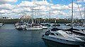 A view of Nieuwpoort marina from the south side with boats
 -
 A view of the beach and the pier at Nieuwpoort
 -
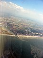 Nieuwpoort taken from the air
 -
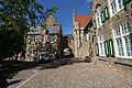 Hendrik-Geeraertplein square
 -
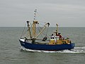 Fishing ship from Nieuwpoort


In literature
Part of the plot in
See also
References
- ^ "Bevolking per gemeente op 1 januari 2022". Statbel.
- ^ "Nieuwpoort". Merriam-Webster.com Dictionary. Retrieved 22 August 2019.
- ^ "Belfries of Belgium and France". UNESCO World Heritage Centre. United Nations Educational, Scientific, and Cultural Organization. Retrieved 5 November 2021.
External links
- Official website - Mainly in Dutch, some info available in French and English
- Startpage of Nieuwpoort - Alle site's binnen Nieuwpoort
- Illustrated Article on Nieupoort & the Yser Front during WW1 at 'Battlefields Europe'
Places adjacent to Nieuwpoort, Belgium | ||||||||||||||||
|---|---|---|---|---|---|---|---|---|---|---|---|---|---|---|---|---|
| ||||||||||||||||
| Bruges |  | |
|---|---|---|
| Diksmuide | ||
| Kortrijk | ||
| Ostend | ||
| Roeselare | ||
| Tielt | ||
| Veurne | ||
| Ypres | ||
| ||
| International | |
|---|---|
| National | |
| Geographic | |
| Other | |