
Lo-Reninge
Lo-Reninge | ||
|---|---|---|
City and municipality | ||
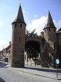
.jpg) Old town hall and Belfry of Lo | ||
 Flag  Coat of arms | ||
Location of Lo-Reninge  | ||
 Lo-Reninge Location in Belgium
Location of Lo-Reninge in West Flanders Region Flemish Region | | |
| Province | West Flanders | |
| Arrondissement | Diksmuide | |
| Government | ||
| • Mayor | Lode Morlion (Dynamisch) | |
| • Governing party/ies | Dynamisch | |
| Area | ||
| • Total | 63.4 km2 (24.5 sq mi) | |
| Population (2018-01-01)[1] | ||
| • Total | 3,289 | |
| • Density | 52/km2 (130/sq mi) | |
| Postal codes | 8647 | |
| NIS code | 32030 | |
| Area codes | 058 | |
| Website | www.lo-reninge.be | |
Lo-Reninge (Dutch pronunciation: World Heritage List in 1999 as part of the Belfries of Belgium and France site.[2]
It is the birthplace of Flemish painter Jacques-Albert Senave.
-
 The 13th century city wall of Lo, with the Caesar's Tree behind it.
 -
 The Margriet windmill
 -
 Sint-Pieter's church in Lo

.jpg)
.jpg)
References
- ^ "Wettelijke Bevolking per gemeente op 1 januari 2018". Statbel. Retrieved 9 March 2019.
- ^ "Belfries of Belgium and France". UNESCO World Heritage Centre. United Nations Educational, Scientific, and Cultural Organization. Retrieved 5 November 2021.
External links
 Media related to Lo-Reninge at Wikimedia Commons
- Official website - Information available in Dutch and limited information available in French, English and German
Places adjacent to Lo-Reninge | ||||||||||||||||
|---|---|---|---|---|---|---|---|---|---|---|---|---|---|---|---|---|
| ||||||||||||||||
| Bruges |  | |
|---|---|---|
| Diksmuide | ||
| Kortrijk | ||
| Ostend | ||
| Roeselare | ||
| Tielt | ||
| Veurne | ||
| Ypres | ||
| ||
| International | |
|---|---|
| Geographic | |
This West Flanders location article is a stub. You can help Wikipedia by expanding it. |