
State highways in California
.svg) .svg)  Standard route signage in California | |
 | |
| System information | |
|---|---|
| Notes | All classes of state-numbered highways are generally state-maintained. |
| Highway names | |
| Interstates | Interstate X (I-X) |
| US Highways | U.S. Route X (US X) |
| State | State Route X (SR X) |
| System links | |
The state highway system of the U.S. state of California is a network of highways that are owned and maintained by the California Department of Transportation (Caltrans).
Each highway is assigned a Route (officially State Highway Route
The California Highway Patrol (CHP) is tasked with patrolling all state highways to enforce traffic laws.[3]
Overview

California's highway system is governed pursuant to Division 1 of the California Streets and Highways Code, which is one of the 29 California Codes enacted by the state legislature. Since July 1 of 1964, the majority of legislative route numbers, those defined in the Streets and Highways Code, match the sign route numbers. For example, Interstate 5 is listed as "Route 5" in the code.
On the other hand, some short routes are instead signed as parts of other routes — for instance,
The state may relinquish segments of highways and turn them over to local control. If the relinquished segment is in the middle of the highway's route, the local jurisdiction is usually required to install and maintain signs directing drivers to the continuation of that highway; they are not generally required to do so if the relinquishment effectively truncates the highway at one end, or is done as part of the process to re-route a highway. The state may also delete a highway completely and turn over an entire state route to local control.
Some new alignments are considered supplemental
History
The first legislative routes were defined by the State Highway Bond Act in 1909, passed by the California State Legislature and signed by Governor James Gillett. These, and later extensions to the system, were numbered sequentially. No signs were erected for these routes.
The
In 1934, after the major expansion of the state highway system in 1933 by the California Legislature, California sign route numbers were assigned by the California Division of Highways (predecessor to Caltrans). The California sign route numbers were assigned in a geographical system, completely independent of the legislative routes. Odd-numbered routes ran north–south and even-numbered routes ran east–west. The routes were split among southern California (ACSC) and central and northern California (CSAA) as follows:
- 0 or 1 modulo 4: central and northern California
- 2 or 3 modulo 4: southern California
For instance,
The Interstate Highway System numbers were assigned by AASHO in late 1959. In 1963 and 1964, a total renumbering of the legislative routes was made, aligning them with the sign routes. Some changes were also made to the sign routes, mostly related to decommissionings of U.S. Routes in favor of Interstates.
Since the 1990s, many non-
Nomenclature in California English
One
- Signage along northbound U.S. Route 101 reflecting the different lexicon usage
-
 Signage at the 110 Freeway interchange in Los Angeles, with the leftmost sign for the 101 north listing both its name, the Hollywood Freeway, as well as its destination, Ventura
 -
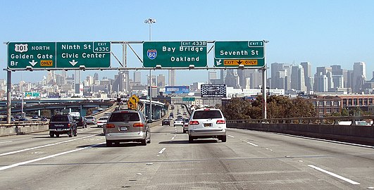 Signage at the Interstate 80 interchange in San Francisco, with the leftmost sign for US 101 north only listing its destination, the Golden Gate Bridge


List of routes
The list of routes, as defined in the California Streets and Highways code, is split into the following pages:
- List of Interstate Highways in California
- List of U.S. Routes in California
- List of state highways in California
Former U.S. Routes In California


- U.S. Route 40
- U.S. Route 40 Alternate
- U.S. Route 48
- U.S. Route 60
- U.S. Route 66
- U.S. Route 70
- U.S. Route 80
- U.S. Route 91
- U.S. Route 99
- U.S. Route 99E (central California)
- U.S. Route 99E (northern California)
- U.S. Route 99W (central California)
- U.S. Route 99W (northern California)
- U.S. Route 101A
- U.S. Route 101 Bypass(San Francisco Bay area)
- U.S. Route 101 Bypass(Los Angeles & Orange counties)
- U.S. Route 101E
- U.S. Route 101W
- U.S. Route 299
- U.S. Route 399
- U.S. Route 466
See also
 California Roads portal
- Deleted California State Highways
- Unconstructed California State Highways
- Scenic California State Highways
- List of county routes in California
References
- ^ California Streets and Highways Code, Section 231
- Caltrans, Other State Highway Routes
- ^ Cal. Sts. & High. Code §§ 2400, 2401.
- ^ Metadata for ST_HWY GIS data layer (PDF)
- ^ Simon, Mark (2000-06-30). "'The' Madness Must Stop Right Now". San Francisco Chronicle. Retrieved 2009-09-22.
- ^ Simon, Mark (2000-07-04). "Local Lingo Keeps 'The' Off Road". San Francisco Chronicle. Retrieved 2009-09-22.
- ^ Simon, Mark (2000-07-29). "S.F. Wants Power, Not The Noise / Brown rejects docking floating plant off city". San Francisco Chronicle. Retrieved 2009-09-22.
- ^ Rose, Joseph (April 16, 2012). "Saturday Night Live's 'The Californians': Traffic's one big soap opera (video)". The Oregonian. Portland, Oregon. Retrieved December 3, 2013.
- ^ S2CID 144010897.
External links
- California Highways - Provides a complete history of California State Routes and every state route.
- Road Signs of California
- AARoads California Highways Page
- 1964 Highway Renumbering
- Historic California U.S. Routes
- California by RV - Provides complete maps of California Main State Routes.