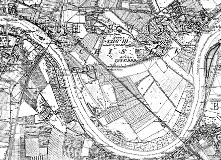
Little Sutton, Chiswick

Little Sutton was one of the four constituent medieval villages of Chiswick, in what is now West London, and the site of a royal manor house, Sutton Manor, later Sutton Court. The great house was accompanied by a small hamlet without a church of its own.
The manor was used by four kings of England, Richard II, Henry IV, Henry V, and Henry VI, and Mary, Oliver Cromwell's daughter, lived there. The name survives in local street and house names.
Geography
Much of the area was still rural until late in the 19th century. Little Sutton, one of the four constituent villages of Chiswick, was about the centre of the parish of Chiswick at that time; Strand-on-the-Green lies to the west, Old Chiswick to the east, and Turnham Green to the north. It is now part of the Grove Park district.[1]
History
Sutton Manor

Sutton Manor is recorded from 1181. The lands of Sutton and Chiswick had by then already been given as an endowment for the
Sutton Court
In 1795 the house was remodelled as Sutton Court; it stood to the south of the former moated house, at what is now the corner of Sutton Court Road and Fauconberg Road. In 1845 it served as a boy's boarding school, run by Frederick Tappenden. It was demolished and replaced by the "Sutton Court Mansions" block of flats in 1905.[2][3]
-
Sutton Court, the remodelled manor house, 1844
-
Sutton Court Mansions, Fauconberg Road, 1905
Little Sutton
Little Sutton was never more than a small hamlet without a church; by 1703 there were some almshouses, and there appears to have been an inn named the Queen's Head, documented in 1722 and 1862 (if they were the same building).
-
Little Sutton Cottage, 1676
-
The Hole in the Wall, 1925,
formerly the Queen's Head, 1676
References
- ^ Clegg 1995, pp. 6, 12, 17.
- ^ a b c d e f g Clegg 1995, pp. 13, 16.
- ^ a b c d Wisdom 2008.
- ^ Anderson 1862, p. 29.
- ^ a b c Baker 1982.
- ^ "Little Sutton Cottage". British Listed Buildings. Retrieved 15 July 2021.
- ^ a b Clegg 1995, pp. 19–20.
Sources
- Anderson, James (1862). Memorable Women of the Puritan Times. Vol. 2. Blackie and Son.
- Baker, T. F. T.; et al. (1982). "Chiswick: Growth". A History of the County of Middlesex: Volume 7: Acton, Chiswick, Ealing and Brentford, West Twyford, Willesden. British History Online.
- Clegg, Gillian (1995). Chiswick Past. Historical Publications. ISBN 0-94866-733-8.
- Wisdom, James (2008). "Sutton Court, the Earl of Burlington & Chiswick House Grounds". Brentford and Chiswick Local History Society Journal (17).


