
Chiswick High Road

Chiswick High Road is the principal shopping and dining street of
History
Chiswick High Road follows the alignment of the Roman road to Silchester as it leads west from London.[1] Near the area of Turnham Green in Chiswick it was joined by another Roman road, which thus also followed part of the course of the High Road.[2] The road continued to be London's main route west until the 1950s when the A4 dual carriageway was built further to the south across Chiswick.[3]
In the English Civil War, the royalist forces under Prince Rupert, advancing on London from Oxford along the main road, were halted in a skirmish, the 1642 Battle of Turnham Green, by the forces of the Earl of Essex. The royalists withdrew, and never again threatened the capital.[4]
Several large houses were built in Turnham Green along the High Road in the 17th century; John Bowack recorded in 1706 that the area had as many inhabitants as the old village of Chiswick, which is some way to the south of the High Road, on the river Thames. In the 18th century, the High Road between Acton Lane and Hammersmith was bordered "intermittently" with large detached houses.[5]
The High Road was a
In November 1805,
In 2022, Chiswick High Road provided the basis for the local historian Wesley Henderson-Roe's British Association for Local History award-winning study of changes to shopping habits, based on surveys of the road's shops conducted in 1936 and 2020.[10]
-
![Sale of Linden House, 1831, by the notorious Thomas Griffiths Wainewright[9]](//upload.wikimedia.org/wikipedia/commons/thumb/8/83/Sale_of_Linden_House%2C_Turnham_Green%2C_1831.jpg/299px-Sale_of_Linden_House%2C_Turnham_Green%2C_1831.jpg) Sale of Linden House, 1831, by the notorious Thomas Griffiths Wainewright[9]
Sale of Linden House, 1831, by the notorious Thomas Griffiths Wainewright[9] -
 Turnham Green north side with smithy and Crown and Anchor pub (before it was rebuilt), 1863
 -
 Chiswick High Road (to the junction with Goldhawk Road) and King Street, Hammersmith, late 19th century. The buildings on the left have survived.
![Sale of Linden House, 1831, by the notorious Thomas Griffiths Wainewright[9]](/File:Sale_of_Linden_House,_Turnham_Green,_1831.jpg)


Street
Chiswick High Road runs the 2.6 kilometres (1.6 mi) from
The street offers many restaurants, bars, and pubs; Time Out describes it as "an undeniably posh but very friendly bubble".[13]
Gunnersbury
On the north of Chiswick High Road in Gunnersbury is the
On the south side is the 18-storey high BSI (
-
 The Gunnersbury, formerly the John Bull music venue
 -

-
 Chiswick Business Park
lake and landscaping
.jpg)


Facing Turnham Green
The 1910
The Crown and Anchor pub, facing the common from the corner of the High Road and Belmont Road, is a Grade II listed early 19th century building. It is of brown brick over three storeys with flat-arched double-hung sash windows. The ground floor is covered with late 19th century tiles and plaques stating "Young and Co. Ales & Stouts". Above the corner doorway on the upper floors is a large round-arched plaque depicting a yellow-coloured
-
 The Old Pack Horse
 -
 The Chiswick Empire in 1913
 -
 The Crown and Anchor
.jpg)


On Turnham Green common
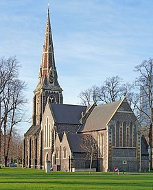
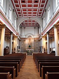
The Grade II listed Victorian era Christ Church, Turnham Green, in the middle of the common to the south of the High Road, was designed by George Gilbert Scott. It was completed in 1843 as a short five-sided chancel with an apse, in the "early English lancet style"[21] with a tall spire. It was extended in length by James Brooks in 1887 to provide a square eastern end.[21]
The eastern tip of the common, where Heathfield Terrace joins the High Road, is marked by the Chiswick War Memorial, built in 1921.[22] It too is Grade II listed, both for its historic and for its architectural interest. It is an obelisk designed by Edward Willis, the council's engineer and architect.[23]
-
-
 Chiswick War Memorial
in snow


Heathfield Terrace to Chiswick Lane
The Old Fire Station on the south side of Chiswick High Road was purpose-built in 1891.[24] In 1911, it was equipped with a motor fire escape and ambulance, allowing it to claim it was one of the best in London. The building was provided with a tall tower to hang up the leather hosepipes to dry.[25][26] Its façade is decorated with a carving of a fireman's helmet.[27] It closed in 1963, the station moving to new premises on Heathfield Terrace. The old station has since been used as a restaurant.[28][29]
Chiswick's old police station was built on the corner with Windmill Place in 1871. In 1890 it held 73 policemen; by 1926, the total had risen to 126. It was closed in 1972 when the police station moved across the road to a new building. The old station served as Carvosso's restaurant, and then as The Crown restaurant.[30][31]
In 2001, a statue of the painter William Hogarth with his dog Trump, made by Jim Mathieson, was unveiled on the High Road, not far from Hogarth's House, where he lived from 1749 until his death in 1764.[32]
-
 Old Fire Station, 1891
 -
 Sculpture on Old Fire Station
 -
 The old police station, built 1871,
then The Crown restaurant -
 Statue of William Hogarth, 2001

_(cropped).jpg)


The 1886 Roman Catholic Church of
-
 Our Lady of Grace and St Edward, 1886, tower added in 1930
 -
 Our Lady of Grace and St Edward, interior


The High Road has for centuries provided ample inns to refresh thirsty travellers. The Roebuck, the Barley Mow and the Coach & Horses were all licensed drinking premises in the 18th century; by the 1820s, some were able to book stage coaches for their guests. The Roebuck was briefly renamed to the 'Rat and Parrot' in the 1990s; the present building, from 1895 replacing an earlier structure, is decorated with stucco and relief statues of stags on its front and side pediments.
-
 Packhorse and Talbot Inn, the wide pavement (right) indicating the old market place
 -
 The George IV, 1931–32, replacing an earlier pub
 -
 The Roebuck, 1895,
replacing an earlier inn
.jpg)


Barley Mow Passage and Bourne Place
Just off Chiswick High Road and parallel to it is Bourne Place, with the sole surviving large detached house of those along the High Road in the 18th and 19th centuries. Afton House, since 1919 the Chiswick Memorial Club, is a Grade II listed building, built circa 1800. It is in brown brick with five bays of double-hung sash windows over four floors; the ground floor and entrance are stuccoed. Its large front garden has been replaced by buildings along the south side of the High Road.[36]
Leading westwards from Bourne Place is the narrow Barley Mow Passage, still with an industrial air. The
-
 Afton House, Bourne Place: its front garden once stretched to the High Road.
 -
 Afton House's doorway
 -
 Voysey HouseCharles Voysey, 1902, showing the bridge that once spanned Barley Mow Passage
 -
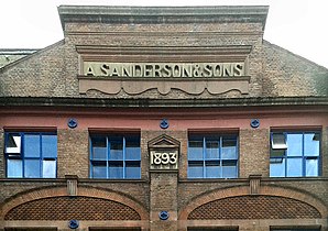 A Sanderson & Sons 1893: detail of Devonshire Works, Barley Mow Passage
 -
 Barley Mow Passage, Voysey House and Devonshire Works. The tower of the Catholic church is in the background.


Chiswick Lane to Goldhawk Road
Nos 1-21 Chiswick High Road, on the south side, was designed by William Blore in 1837 and built in 1838. The entire building, then named William's Terrace, survives as a terrace of ten three-storey houses, though with some changes to the front, and additional structures in what were the front gardens, making it less conspicuous than it was when built. The 1837 print omits the roofs and chimneys to make the building look grander and more formal.[39]
-
 William's Terrace, 1-21 Chiswick High Road, 1837 print by William Blore, architect

-
 1-21 Chiswick High Road in 2021

The Power House, on the north of Chiswick High Road next to the bus garage, was built as an electricity generating station for the London United Electrical Tramway Company between 1899 and 1901. Pevsner describes it as a "monumental free Baroque brick and stone composition ... by far the most exciting building [on the High Road, and] ... the best surviving example in London from the early, heroic era of generating stations whose bulky intrusion in residential areas was tempered by thoughtful architectural treatment".[40] When it fell into disuse it was threatened with demolition; the campaign to save it resulted in its Grade II listing.[41]
-
 The Power House from southwest corner
 -
 'Electricity' and 'Locomotion' sculpture on the London United Electrical Tramway Company's Power House
 -
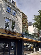 Chiswick Cinema, opened 2021
.jpg)
.jpg)

Conservation areas
In 2015,
In 2021, Hounslow Council reappraised the Turnham Green Conservation area.[36] This is adjacent to the Chiswick High Road conservation area, covering the part of the High Road from Chiswick Road in Gunnersbury to the west, via the whole of Turnham Green common and the buildings facing its north side along the High Road, to Clifton Gardens in the east. It takes in a substantial area to the south of the common, and was extended in 2019 to include the streets between Sutton Court Road and Duke's Avenue down to the Great West Road.[36]
Cycling and traffic
In 2020, Hounslow Council and
-
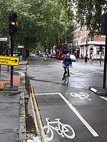 Cycle route 9 on Chiswick High Road

Notes
- ^ George Griffiths was the son of Ralph Griffiths, who became rich from publishing the erotic novel Fanny Hill.[7]
References
- ^ Margary 1973, p. 85.
- ^ a b Clegg 1995, p. 10.
- ^ a b c d e "Chiswick High Road Conservation Area Appraisal Consultation Draft" (PDF). London Borough of Hounslow. 13 April 2015. Archived (PDF) from the original on 30 July 2021. Retrieved 30 July 2021.
- ^ Clegg 1995, pp. 29–30.
- ^ Clegg 1995, p. 26.
- ^ "Points of Interest". The Trafalgar Way. Archived from the original on 29 July 2021. Retrieved 29 July 2021.
- ^ a b Motion, Andrew (5 February 2000). "The deadly dandy". The Guardian. Archived from the original on 29 July 2021. Retrieved 29 July 2021.
- ^ Clegg 1995, pp. 28, 42–43.
- ^ a b Hammond, Peter (1998). "Thomas Griffiths Wainewright". Brentford and Chiswick Local History Society. Archived from the original on 29 July 2021. Retrieved 29 July 2021.
- ^ "National Award for Study of the History of Chiswick Shopping". Chiswick W4. 22 June 2022. Retrieved 22 June 2022.
- ^ "A205". Google Maps. Archived from the original on 29 July 2021. Retrieved 29 July 2021.
- ^ "SABRE Roads by Ten - A315". Sabre Roads. Retrieved 30 August 2021.
- ^ Walker-Arnott, Ellie (18 August 2017). "18 champion things to do on Chiswick High Road". Time Out. Archived from the original on 29 July 2021. Retrieved 29 July 2021.
- ^ a b Cherry & Pevsner 1991, p. 406.
- ^ "BSI and Britannic strike 41.3 million property deal". BSI. 9 November 2000. Archived from the original on 29 July 2021. Retrieved 29 July 2021.
- ^ a b Clegg, Gillian. "Pubs". Brentford & Chiswick Local History Society. Archived from the original on 23 July 2021. Retrieved 30 July 2021.
- ^ "Iris Murdoch Deemed Top Pick for Next Chiswick Blue Plaque". Chiswick W4. Retrieved 19 October 2021.
- ^ Historic England. "The Old Packhorse public house (1240781)". National Heritage List for England. Retrieved 17 December 2013.
- ^ Pain, Christina (2001). "The Chiswick Empire". Brentford and Chiswick Local History Journal (10). Archived from the original on 20 July 2021. Retrieved 29 July 2021.
- ^ "Crown and Anchor Public House A Grade II Listed Building in Hounslow". British Listed Buildings. Archived from the original on 13 January 2021. Retrieved 30 July 2021.
- ^ a b Historic England. "Christ Church (1189239)". National Heritage List for England. Retrieved 30 April 2018.
- ^ "Monument: Chiswick war memorial - Turnham Green". London Remembers. Archived from the original on 29 July 2021. Retrieved 29 July 2021.
- ^ Historic England. "Chiswick War Memorial (1424996)". National Heritage List for England. Retrieved 30 July 2021.
- ^ Clegg, Gillian. "Brief History of Chiswick". Brentford and Chiswick Local History Society. Archived from the original on 28 July 2021. Retrieved 28 July 2021.
- ^ Bolton, Diane K.; Croot, Patricia E. C.; Hicks, M. A. "Chiswick: Local government Archived 2021-07-28 at the Wayback Machine", in A History of the County of Middlesex: Volume 7, Acton, Chiswick, Ealing and Brentford, West Twyford, Willesden, ed. T. F. T. Baker and C. R. Elrington (London, 1982), pp. 86-90. British History Online [accessed 28 July 2021].
- ^ Clegg 1995, pp. 78–81.
- ^ Cherry & Pevsner 1991, p. 404.
- ^ "197 Chiswick Fire Station, London". Box 9 Design Ltd. Archived from the original on 28 July 2021. Retrieved 28 July 2021.
- ^ "No. 197 Chiswick Fire Station To Open This Month". Chiswick w4. 4 April 2016. Archived from the original on 28 July 2021. Retrieved 28 July 2021.
- ^ Clegg 1995, p. 77.
- ^ "The Crown". Andy Hayler's Restaurant Guide. 5 February 2019. Archived from the original on 30 July 2021. Retrieved 30 July 2021.
- ^ "Obituary of Jim Mathieson". The Guardian. 24 April 2003. Archived from the original on 30 July 2021. Retrieved 30 July 2021.
- ^ "Our Lady of Grace and St Edward Roman Catholic Church A Grade II Listed Building in Hounslow". British Listed Buildings. Archived from the original on 31 July 2021. Retrieved 30 July 2021.
- ^ "Presbytery of Roman Catholic Church of Our Lady of Grace: A Grade II Listed Building in Hounslow". British Listed Buildings. Archived from the original on 31 July 2021. Retrieved 31 July 2021.
- ^ Clegg 1995, p. 94.
- ^ a b c "Turnham Green Conservation Area Appraisal". London Borough of Hounslow. January 2021. Archived from the original on 25 August 2021. Retrieved 30 July 2021.
- ^ "Voysey House, Hounslow". British Listed Buildings. Archived from the original on 21 October 2013. Retrieved 9 October 2013.
- ^ "Sanderson's Set to Make Historic Return Home to Chiswick: Wallpaper company is moving back into Voysey House". Chiswick W4. 19 March 2024. Retrieved 28 March 2024.
- ^ "Historic Print of William's Terrace in 1837 forms part of exhibition on Chiswick's Past". Chiswick W4. Archived from the original on 25 August 2021. Retrieved 25 August 2021.
- ^ Cherry & Pevsner 1991, p. 405.
- ^ "Former Tramways Sub-Station at Rear of Number 72 Chiswick High Road". britishlistedbuildings.co.uk. Archived from the original on 17 March 2018. Retrieved 17 March 2018.
- Ballet Rambert. Archivedfrom the original on 31 July 2021. Retrieved 31 July 2021.
- ^ "How Britain's oldest dance company still thrives on reinvention as it approaches its 90th birthday". The Independent. 3 January 2016. Archived from the original on 25 July 2020. Retrieved 31 July 2021.
- ^ Stronach, Dia (5 June 2021). "Share Facebook Twitter Chiswick Cinema Announces Opening Date". The Chiswick Herald. Archived from the original on 31 July 2021. Retrieved 31 July 2021.
- ^ Mellor, Josh (15 February 2021). "Mixed Views on Cycleway 9 from Local Business Owners". Chiswick W4. Archived from the original on 15 July 2021. Retrieved 30 July 2021.
- ^ "Chiswick to Brentford town centre" (PDF). Transport for London. Archived (PDF) from the original on 24 January 2019. Retrieved 30 July 2021.
- ^ Lydall, Ross (23 November 2020). "Cycle lane wars: Row over Covid traffic scheme as fight heads to High Court". Evening Standard. Archived from the original on 30 July 2021. Retrieved 30 July 2021.
Sources
- OCLC 24722942.
- Clegg, Gillian (1995). Chiswick Past. Historical Publications. ISBN 0-94866-733-8.
- ISBN 0-212-97001-1.
| Ealing |
| .jpg) | |||||||||||||
|---|---|---|---|---|---|---|---|---|---|---|---|---|---|---|---|
| Hounslow |
| ||||||||||||||
| Transport | |||||||||||||||
| Other |
| ||||||||||||||