
Acton Green, London
| Acton Green | |
|---|---|
 Acton Green Location within Greater London | |
| OS grid reference | TQ205805 |
| • Charing Cross | 5.9 mi (9.5 km) WNW |
| London borough | |
| Ceremonial county | Greater London |
| Region | |
| Country | England |
| Sovereign state | United Kingdom |
| Post town | LONDON |
| Postcode district | W4 |
| Dialling code | 020 |
| Police | Metropolitan |
| Fire | London |
| Ambulance | London |
| UK Parliament | |
| London Assembly | |
Acton Green is a residential neighbourhood in Chiswick and the London Borough of Ealing, in West London, England. It is named for the nearby Acton Green common. It was once home to many small laundries and was accordingly known as "Soapsuds Island".
History

The public parkland of Acton Green common adjoins Chiswick Back Common; before they were divided by the railway embankment for the District and Piccadilly lines,[1] both were part of the English Civil War battlefield of the Battle of Turnham Green.[2]
South Acton, especially the Acton Green district, was once famous for its laundries, and was known as "Soapsuds island".[3] There were some 60 laundries in 1873, rising to over 170 in 1890, most of the washing being done by hand. The 1901 census recorded as laundry workers 568 men and 2,448 women. The number of laundries fell to 50 in 1956, by then all automated: still the largest concentration of such businesses in Britain at that time.[4] The business supported light industries that produced laundry requisites, including baskets, laundry hampers, mangles, washing machines, tubs, and wringers.[5]
Facing the east of the common is St Michael and All Angels, Bedford Park; it and The Tabard Inn facing it across Bath Road, were built in 1880.[6][7] The 1894 Ordnance Survey map shows Acton Green bounded to the west by railway lines, and to the east by the boundary of Bedford Park; at that time, both the west of Bedford Park and the east of Acton Green consisted of orchards.[8]
-
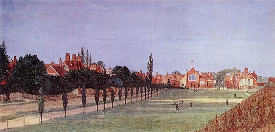 Painting, looking east, of Acton Green common to St Michael's and The Tabard Inn by Frederick Hamilton Jackson, 1882. The Victorian era Bedford Park development is on the left, the London Underground railway embankment on the right.

Housing
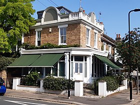
Most of the housing of Acton Green is to the northwest of the common; to its east is the Bedford Park area, developed speculatively as a place for artists at the same time as St Michael's and The Tabard.[9] There were formerly numerous small shops in the centre of Acton Green on Cunnington Street and Kingswood Road. These included confectioners, fish and chip shops, grocers, and off-licences. The area also held a variety of schools, now all closed.[5]
-
 A corner house with end pediment and swag,
Church Path -
 Providence Villa,
Cunnington Street -
 A former corner shop,
Antrobus Road -
 The Gothic House,
Rothschild Road -
 The Mosaic House,
Fairlawn Grove -
 Red brick terraced houses,
South Parade -
 Decorative swag,
South Parade


St Alban's Church
On the north side of the common, facing South Parade, is the red-brick with stone facings
-
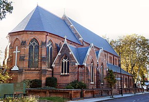 St Alban's Church, opened 1888
 -
 Old Vicarage, South Parade, sharing architectural idioms with its church


West side of the common
Facing the west of the common are the
-
 Detail of Fairlawn Court, Acton Lane
 -
 Chiswick Green Studios, formerly anEvershed & Vignolesfactory


Public houses
Duke of Sussex
Nearby, facing the north of the common is the 1898 Duke of Sussex public house; it replaced an earlier beerhouse founded by 1842.[14] The current "elaborately decorated"[1] building was designed by the pub architects Shoebridge & Rising, and is Grade II listed. It has two storeys, with dormer windows for the attic and cellars below. The main front faces east on to Beaconsfield Road, with three bays, two of them with dormers, separated by a small half-round Diocletian window, and the third an extension to house the kitchens and staircase. The walls are covered in white stucco, with the first storey hung with flat red tiles.[1][15] The first storey and attic windows below the dormers are "Ipswich oriels" under ornamental cornices. The ground floor bar area has big arched windows, and an elaborate corner doorway; the doorway to the north is adorned with ornamental ironwork. Parts of the original interior partitioning survive, providing "an unusually rich, turn-of-the-century pub interior".[1]
- Duke of Sussex public house, 1898
-
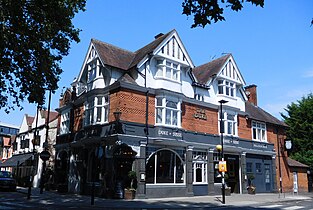 Exterior
 -
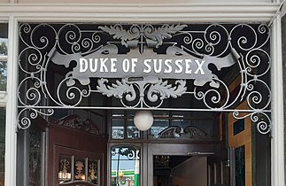 Ornamental ironwork


Other
On the corner of Bollo Lane, which marks the western edge of the area, and Montgomery Road is the Bollo, a gastropub. It opened soon after 1900 as 'The Railway Hotel', complete with a painting of a railway locomotive on the outside wall. It then became in turn 'The Railway Tavern', 'The Orange Kipper' (1988), 'The Bollo House', and finally the Bollo.[14]
On the corner of Evershed Walk and Acton Lane is The Swan, opened in 1871 by the Phoenix Brewery of Latimer Road in what had been a beerhouse owned by James Brown. Its exterior featured in a 1980s television
-
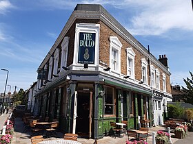 The Bollo, Bollo Lane
 -
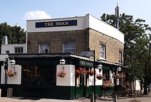 The Swan, Acton Lane


Transport
The London Buses route 94 to Piccadilly Circus terminates at the northwestern corner of Acton Green common.[18]
References
- ^ a b c d e f g "Acton Green Conservation Area Character Appraisal" (PDF). Ealing Borough Council. March 2008. pp. 5, 7, 15–16.
- ^ "The Battle of Turnham Green". Chiswick W4. 19 November 2004. Retrieved 13 November 2015.
- ^ "Acton's Industry: South Acton - Soapsud Island". Acton History. Retrieved 23 July 2021.
- ^ A History of the County of Middlesex: Volume 7, Acton, Chiswick, Ealing and Brentford, West Twyford, Willesden. Vol. 7. Victoria County History. 1982. pp. 23–30.
- ^ a b "History". Acton Green Residents' Association. 2021. Retrieved 13 August 2021.
- OCLC 24722942.
- ^ "A brief history of the Church". St Michael & All Angels. Retrieved 19 November 2015. This is based on Broom, Michael. The Birth of A Parish – The Creation of St Michael & All Angels, Bedford Park. St Michael & All Angels.
- ^ "Map of Chiswick, 1893 - 1894". Ordnance Survey. 1894. Retrieved 13 August 2021.
Scale 1:10,560 Ordnance Survey County Edition Series
- OCLC 61702983.
- ^ Pevsner, Nikolaus (1951). The Buildings of England: Middlesex. Penguin Books.
- ^ "St Alban's on South Parade, Acton Green, London W4". The Victorian Web. 7 July 2017. Retrieved 2 November 2018.
- ^ A History of the County of Middlesex: Volume 7, Acton, Chiswick, Ealing and Brentford, West Twyford, Willesden. Vol. 7. Victoria County History. 1982. pp. 35–39.
- ^ "Chiswick Green Studios". Architecture Arc. Retrieved 22 July 2021.
- ^ a b Clegg, Gillian. "Pubs". Brentford and Chiswick Local History Society. Retrieved 23 July 2021.
- OCLC 24722942.
- ^ "Swan". Campaign for Real Ale. Retrieved 23 July 2021.
- ^ "The Swan". Harden's. Retrieved 23 July 2021.
- ISBN 978-1-85414-303-7.
Adjoining districts | ||||||||||||||||
|---|---|---|---|---|---|---|---|---|---|---|---|---|---|---|---|---|
| ||||||||||||||||
| Ealing |
| .jpg) | |||||||||||||
|---|---|---|---|---|---|---|---|---|---|---|---|---|---|---|---|
| Hounslow |
| ||||||||||||||
| Transport | |||||||||||||||
| Other |
| ||||||||||||||

