
Lousberg
| Lousberg | |
|---|---|
 View of the Lousberg from Laurensberg | |
| Highest point | |
| Elevation | 264DE-NHN |
| Coordinates | 50°47′13″N 6°4′45″E / 50.78694°N 6.07917°E |
| Geography | |
| Location | Aachen, North Rhine-Westphalia, Germany |
At 264 meters, the Lousberg is a prominent elevation on the northern edge of the historic center of Aachen, which was laid out as a forest and mountain park at the beginning of the 19th century according to plans by Maximilian Friedrich Weyhe.[1] The origin of the name is not entirely clear. It could come from lousen ("to look"),[2] since the mountain offers an excellent panoramic view, or it could be traced back to Louis the Pious, the son of Charlemagne. Another explanation has to do with the Aachen dialect term lous, which means "clever".
Geology, formation
At the foot of the Lousberg, dark gray, clayey to sandy sediments of the so-called Hergenrath layers were deposited, which formed in a swampy river delta. Silicified wood, charcoal, and numerous concretions of marcasite are embedded in these layers. Due to the water-storing properties of the deposits, the clay of the Hergenrath layers forms the most important spring horizon in the region, both on the Lousberg and in the Aachen Forest.
Subsequently, during the Upper Cretaceous, the area was gradually submerged by the sea, and 30–50 m thick quartz sands of the Aachen Formation were deposited, which were mined in small sand pits on the lower slopes of the Lousberg (e.g. at the present playground at the end of Kupfer Street). There is a clear erosional unconformity between the sands of the Aachen Formation and the younger Vaals Formation of the Campanian. The sands of the Vaals Formation are characterized by an increased occurrence of glauconite. Because of their greenish-brown weathering color, these beds were formerly known as the Vaals Green Sands.
In the Campanian, tectonic movements began to increase, which are associated with the sinking of the Lower Rhine Bight and led to the uplift of the Lousberg Floe. The Vijlen and Orsbach limestones were probably not primarily sedimented due to their high altitude.
It was not until the Maastrichtian that the Lousberg floe was submerged again due to a rise in sea level. Dead microorganisms were deposited in a calcareous mud, which today forms the so-called Vetschau limestone. The original thickness of the limestone layer on the Lousberg was about 6 meters. The upper 4.5 meters contained[3] layers of brown flint, which were the subject of a Neolithic quarry. All but a small amount of the flint was quarried, and the unused limestone material was dumped on the surrounding slopes. Due to the poor consolidation of this debris, small landslides still occur today, as evidenced by the uprooted trees and cracks in the footpaths.
Fauna and flora

From an ornithological point of view, the Lousberg is very rich in species, as studies carried out by the RWTH Aachen University have shown. The population of bats, amphibians, and reptiles is also remarkable. The amphibians find spawning waters in the Soers north of the Lousberg. There is a continuous yew forest on the plateau. In the former St. Raphael monastery park to the north, the listed Müschpark, there are extensive stands of wild daffodils.
History
During the Neolithic period, about 5,500 to 5,000 years ago, flint was mined and worked intensively on the Lousberg. This gray flint, easily recognizable by its characteristic chocolate-brown color zones, was used to make axes and other tools, most of which were polished on-site or brought to settlements as semi-finished products.
The striking coloration of the Lousberg flint makes it a suitable object for studying the distribution of axe blades. The 14C dates of the artifacts found in the Lousberg overburden indicate that the mine was in operation between 3500 and 3000 B.C. Calculations based on the volume of the overburden, the weight of the production waste, and the average weight of the axe blades suggest that about 300,000 axe blanks left the Lousberg. These axe blanks were distributed as far as Belgium (Thieusies, about 160 km by air), central Hesse (Büdingen, about 225 km by air), and eastern Westphalia (Neuenknick near Minden, about 280 km by air).
The Stone Age mining of flint has almost completely reclaimed the central plateau of the Lousberg, which originally consisted of a 6 m thick layer of calcareous limestone. The resulting dumps, up to 4.5 meters thick, are still visible today as a hilly landscape under the yew grove. Finished axes and flint flakes have been found in the area and on the steep slopes.
During the Roman occupation, the limestone was used to build the thermal baths of Aachen, and in the Middle Ages, it was used in the construction of Barbarossa's Wall.
At the beginning of the 19th century, the Napoleonic geographer Jean Joseph Tranchot began the topographic survey of the Rhineland at the scale of 1:20,000, starting from a triangulation point on the Lousberg. On October 17, 1807, the French Ministry of War erected a bluestone obelisk in honor of Tranchot and his colleagues, based on a design by the engineering geographer Capitaine Boucher.[1] The obelisk is a precisely measured central point that served as a starting point for astronomical observations and mapping in the region. From there, other points in the area were determined using the triangulation method, which eventually allowed the entire area to be mapped. When Napoleon was deposed on April 2, 1814, the monument was destroyed. On May 15, 1815, the obelisk was re-erected by order of the Prussian Baron Karl von Müffling, who continued the surveying work on behalf of the Kingdom of Prussia. The inscription praising Napoleon was replaced by the inscription that can still be read today. The damage to the edges of the stone was compensated by chamfering, which is untypical for an obelisk.[4]
-
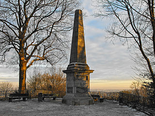 The obelisk on the Lousberg
 -
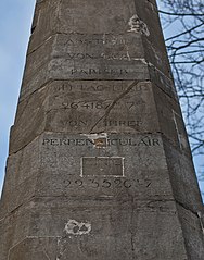 Inscription on the obelisk
 -
 Model in the Centre Charlemagne


.jpg)
It was at this time that the first landscape park in Europe, initiated by citizens (and not by princes), was created on the Lousberg. These efforts were closely linked to the embellishments ordered by Napoleon in 1804, which included the "repair and embellishment of the baths" and the creation of "walks" on the filled-in trenches of the outer city fortifications. The idea of planting the Lousberg is said to have originated in 1806 and to have been promoted by Johann Wilhelm Körfgen (1769–1829), secretary general of the prefecture of the département of Roer. The idea of a park on the Lousberg was combined with the idea of building a society house called the "Belvédère" on the southeastern slope of the mountain. To this end, several citizens, under the chairmanship of Körfgen, joined in a specially created corporation whose purpose was to promote tourism. While the public authorities had to provide the land for the project and carry out the planting work, it was up to the limited company to raise the funds to build the society house. The first plantings on the Lousberg were commissioned in 1807 by Alexandre de Lameth, the prefect of the département of Roer. The plans for the park, based on the principles of the English landscape garden, were drawn up by the court gardener Maximilian Friedrich Weyhe of Düsseldorf, who had also been commissioned by Lameth to submit plans for the redesign of the outer moats. The overall project was overseen by a "Committee for Embellishments," established in 1807. The Lousberg, which had been more or less bare and used as a sheep pasture, was transformed into a wooded park with an extensive tree population by 1818. The society house was built between 1807 and 1810.
Its dilapidation was complained about as early as 1818. In 1827-28 the building was renovated and enlarged under the direction of Adam Franz Friedrich Leydel. On August 29, 1836, the Society House burned down completely after a ball. In 1838 it was rebuilt in the neoclassical style according to Leydel's plans and later renovated and expanded according to Friedrich Joseph Ark's plans. Known as the Belvedere, it functioned as both a restaurant and a casino. It was a popular destination for walkers, along with other features such as the Tranchot Obelisk, a Monopteros on the site of today's revolving tower, and a small Chinese pagoda. The circular path, beginning at the site of today's bronze statues, through the recently restored beech avenue on the north slope, offered spa guests and citizens different views of the city and the surrounding countryside, until all the views converged at the obelisk. The course itself was also dramatically designed by Weyhe, with flat sections alternating with climbs of varying lengths.[5]
-
 The excursion Restaurant "Belvedere" (1896) on the Lousberg
 -
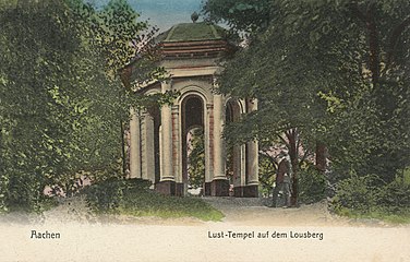 Temple of Pleasure (Monopteros) on the Lousberg


Between 1803 and 1814, General Secretary Johann Wilhelm Körfgen had his Müsch estate, located on the northern flank of the Lousberg in the Soers, transformed into a ferme ornée according to Maximilian Friedrich Weyhe's plans for the Lousberg. In 1866, Weyhe's son Joseph Clemens Weyhe developed the 11-hectare park into today's Müsch Park.
At the end of the 19th century, according to the plans of Aachen's director of gardens Heinrich Grube, the park areas of the Lousberg were extended eastwards to include the areas of the Salvatorberg, so that a network of green spaces could be created with the city fortifications (northern parts of the ring of avenues) planned by Maximilian Friedrich Weyhe from 1807 and with today's municipal gardens designed by Peter Joseph Lenné in 1852.
In 1906, the city of Aachen rebuilt the Kersten Pavilion, a baroque building designed by the Aachen architect Johann Joseph Couven, on the Lousberg. The pavilion, which is about 100 years older than the Lousberg Park, was previously located in the city of Aachen at Annuntiatenbach 22-28 and was part of the city palace of the wealthy dye-works owner Nicolaus Mantels. To save the building from demolition, the city bought it and had it rebuilt on the Lousberg. The pavilion has been managed by the Lousberg Society since 2005 and is used for exhibitions and lectures.
The open-air stage on the Lousberg, which was built like a Greek theater on the hillside facing the city, failed not least because of the Aachen weather.
During World War II, the Belvédère social house and other structures in the park were destroyed. The remains of the columns of the Belvédère can still be seen today and are colloquially known as the "Aachen Acropolis".
The Belvedere Water Tower was built in 1956 to provide water to the western neighborhoods. In the 1980s, however, more efficient pumps made this unnecessary, and in 1988 the tower ceased to function as a water tower altogether. After extensive renovations, it is now used primarily as an office building. For a long time, the top floor of the building housed a café. The café was known for its 360° panoramic view and the automatic movement of tables around the circular area using a slow conveyor belt. A restaurant has since opened in the same space.
Today, the Lousberg is largely wooded and serves as a local recreation area. The extensive park of the former St. Raphael Monastery north of the Lousberg was integrated into the Lousberg Park in 2009. The Lousberg is also the site of the annual summer Lousberg Run and the open-air literature festival "Reading Pleasure on the Lousberg".
- Pictures
-
 Aerial view of Lousberg in the north of Aachen
 -
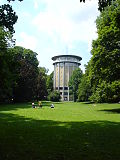 Belvedere water and observation tower
 -
 The columns of the former Belvedere Society House
 -
 Kersten Pavilion


Legend

The Lousberg legend, one of the Aachen legends, explains the existence of the Lousberg as a single mountain in the middle of the Aachen basin in an etiological way.
According to the Aachen Cathedral legend, the people of Aachen tricked the devil into building the cathedral. The devil was out for revenge and wanted to bury the cathedral and the city in the sand forever. However, he was tricked by a poor woman and dropped the pile of sand north of the city, creating a larger and smaller mountain.
Because the woman was "lous", which means "clever" in the Aachen dialect, the larger mountain was called "Lousberg".
The legend is commemorated by a group of bronze statues on the Lousberg, depicting a farmer's wife and a devil, created in 1985 by Aachen artist Krista Löneke-Kemmerling.
References
- ^ a b Dorothée Hugot: Geschichte des Lousbergs. Lousberg Society, retrieved on January 8, 2016.
- ^ Christian Quix: Historisch-topographische Beschreibung der Stadt Aachen und ihrer Umgebungen. DuMont-Schauberg, Köln et al. 1829, p. 125.
- ^ Roland Walter: Aachen und nördliche Umgebung. Mechernicher Voreifel, Aachen-Südlimburger Hügelland und westliche Niederrheinische Bucht (= Sammlung Geologischer Führer. Volume 101). Borntraeger Brothers, Berlin et al. 2010, ISBN 978-3-443-15087-7.
- ^ Marie-Luise Carl. Der Hintergrund zur Kartenaufname der Rheinlande durch Tranchot und von Müffling im Spiegel einer Inschrift, Report on rootsweb.com
- ^ Thomas Terhart, Raimund Mohr: Der Lousberg. Seine Geschichte, seine Verwandlung in einen Waldpark nach dem Plan von Maximilian Friedrich Weyhe und seine Bedeutung für Aachen heute. Student research project at the Chair of Architectural History at RWTH Aachen University, Aachen 1987.
External links
- Entry for Waldpark Lousberg in the European Garden Network EGHN in the database "KuLaDig" of the Rhineland Regional Association
Bibliography
- Resi Hellemann: Die Lousberg-Sage, in: Richard Wollgarten et al.: Aachener Sagen und Märchen, Oecher Platt Association (ed.), Aachen
- Lucrezia Hartmann: Der Aachener Lousbergpark im 19. Jahrhundert. In: ISSN 0342-1805, p. 285–300.
- Rudolf Schmidt: Der Tranchot-Obelisk auf dem Lousberg in Aachen. Eine Dokumentation des Landesvermessungsamtes Nordrhein-Westfalen. Bonn 1988.
- Daniel Schyle: Der Lousberg in Aachen. Ein jungsteinzeitlicher Feuersteintagebau mit Beilklingenproduktion (= Rheinische Ausgrabungen. 66). From Zabern, Mainz 2010, ISBN 978-3-8053-4326-8.
- Thomas Terhart: Der Lousberg-Park in Aachen (= Rheinische Kunststätten. 338). Neusser printing and publishing house, Neuss 1988, ISBN 3-88094-611-6.
- Jürgen Weiner: Der Lousberg – Feuersteinbergbau in der Jungsteinzeit. Ein Führer zur prähistorischen Abteilung des stadtgeschichtlichen Museums Burg Frankenberg Aachen. Museums of the City of Aachen, Aachen 1984.
- Jürgen Weiner: Der Lousberg in Aachen. Ein Feuersteinbergwerk aus der Jungsteinzeit. In: Hansgerd Hellenkemper, Heinz Günter Horn, Harald Koschik (Ed.): Archäologie in Nordrhein-Westfalen. Geschichte im Herzen Europas (= Schriften zur Bodendenkmalpflege in Nordrhein-Westfalen. 1). From Zabern, Mainz 1990, ISBN 3-8053-1138-9, p. 139–142.
- Jürgen Weiner: Der Lousberg in Aachen. Feuersteinbergbau vor 5500 Jahren (= Rheinische Kunststätten. 436). Rhineland Association for Monument Preservation, Cologne 1998, ISBN 3-88094-842-9.