
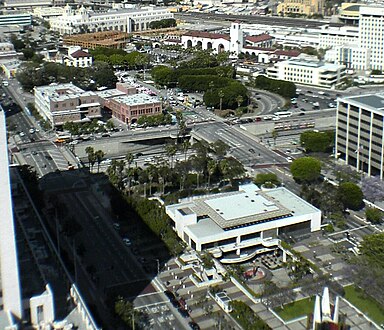
Main Street (Los Angeles)
| Length | 20.9 mi (33.6 km) Wilmington border |
|---|---|
| Major junctions |
|
| North end | 34°03′56″N 118°12′13″W / 34.0655°N 118.2036°W Valley Boulevard in Lincoln Heights |
Main Street is a major north–south thoroughfare in
Route
From the northeast, Main Street begins as a continuation of
Main Street enters
Main Street continues south through
Buildings and sites north of US-101
- Lincoln Park
- Los Angeles Plaza Historic District
Buildings and sites from US-101 to Third Street
-
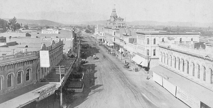 Main Street looking north from Temple, photo by T.E. Stanton, 1886. TheBaker Blockis the prominent building towards the back. Left side: Cosmopolitan Hotel, Farmers and Merchants Bank , Downey Block with Commercial Restaurant.

Main from Plaza south to Arcadia
Gallery (west side)
-
 Sentous Blocka.k.a Sentous Building, 1920
 -

-
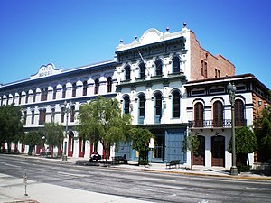
 Vickrey-Brunswig Building
 -
 Plaza House
.png)
_(cropped).jpg)


Gallery (east side)
-
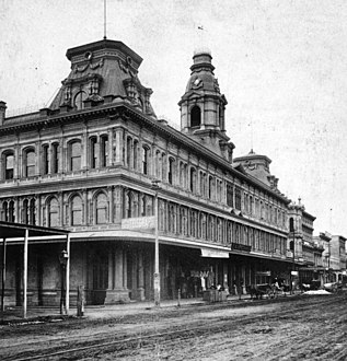
 Pico House in 1875
 -
 Pico House and the Plaza in 1876, photo taken from Fort Moore
 -
 Pico House today
 -
 Pico House, Merced Theater and Masonic Hall


Pico House
Pico House was a luxury hotel built in 1870 by
Masonic Hall
Masonic Hall at 416 N. Main St., was built in 1858 as Lodge 42 of the Free and Accepted Masons. The building was a painted brick structure with a symbolic "Masonic eye" below the parapet. In 1868, the Masons moved to larger quarters further south. Afterward, the building was used for many purposes, including a pawn shop and boarding house. It is the oldest building in Los Angeles south of the Plaza.
Merced Theater
The Merced Theater, completed in 1870, was built in an Italianate style and operated as a live theatre from 1871 to 1876. When the Woods Opera House opened nearby in 1876, the Merced ceased being the city's leading theatre.[3] Eventually, it gained an "unenviable reputation" because of "the disreputable dances staged there, and was finally closed by the authorities."[4]
Plaza House
This two-story building at 507–511 N. Main St. houses part of the
Vickrey-Brunswig Building
This five-story brick building facing the Plaza at 501 N. Main St. houses
Site of Sentous Building
The Sentous Block or Sentous Building (19th c., demolished late 1950s) was located at 615-9 N Main St., with a back entrance on 616-620 North Spring St. (previously called Upper Main St., then San Fernando St.). Designed in 1886 by Burgess J. Reeve. Louis Sentous was a French pioneer in the early days of Los Angeles.[8] The San Fernando Theatre was located here. The site is now part of the El Pueblo parking lot.[9][10]
West side of Main from Republic south to Temple
-
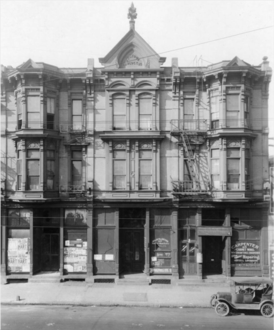
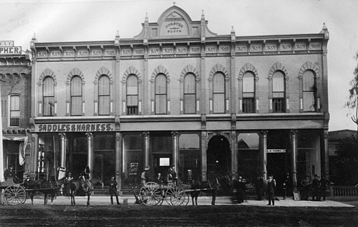
 St. Elmo (orig. Lafayette) Hotel circa 1890

This block is part of the site of the current Spring Street Courthouse. Buildings previously located here include:
- Lafayette Hotel, 343 N. Main, opened in the 1850s, c. 1882 renamed the Cosmopolitan Hotel, then the St. Elmo Hotel.[11] Razed in 1933.[12]
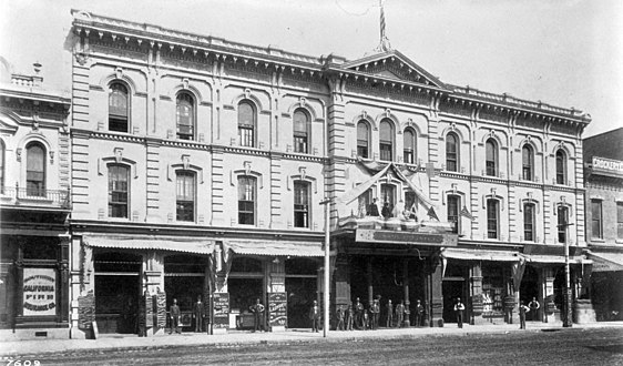
Northwest corner of Temple and Main
-
 View to the NW of Old Downey Block, c. 1870, before Downey Block was built in 1871: "Harris & Jacoby", forerunners to Harris & Frank and Jacoby Bros., and M. Kremer, forerunner of the City of Paris, the city's first department store
 -
 South end of the Downey Block, at the NW corner of Temple/Main, 1880s
 -
 North end of the Downey Block along the west side of Main St., 1887. Temple Block at left; Spring Street runs towards thePhillips Block(tower) in the background at center-left.
 -
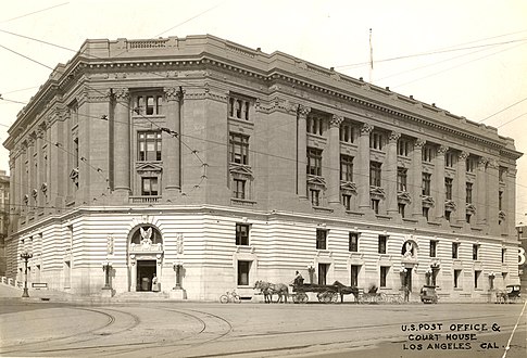 1910 Post Office and Courthousewhich replaced the Downey Block NW corner Temple and Main
 -
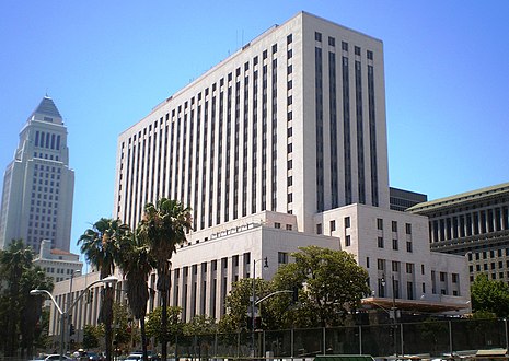 The 1940Spring Street Courthouse, NW corner Temple/Main, 2008


On this corner stood four buildings in succession, the first two of which had a key role in the history of retail in Southern California, as it was home to a number of upscale retailers who would later grow to be big names in the city, and some, regional chains.
- Old Downey Block (?-1871), northwest corner of Temple and Main, Replaced by the Downey Block (1871-1910). Retailers that got their start here included Harris & Jacoby,[15][16] forerunners to the Harris & Frank clothing chain and the large Jacoby Bros. department store; and M. Kremer,[17] forerunner of the Los Angeles City of Paris.
- Downey Block (1871–1910), replaced by the New Post Office in 1910. Retailers who were located here included Coulter's (1878-9),[18] Jacoby Bros. (1878-9),[19] and Quincy Hall (1876–1882),[20] forerunner of Harris & Frank.
- New Post Office also known as the Spring Street Courthouse, opened in 1940.[21]
- Spring Street Courthouse, opened in 1940.[21]
East side of Main from Arcadia south to Commercial
Baker Block
-
 Abel Sterns adobe c. 1857. Built in 1835-8, demolished in 1877 to make way for the Baker Block
 -
 Baker Block, built 1878, demolished 1942, site now underUS 101freeway. Photo c. 1880
 -
 Lithograph of the Baker Block
.jpg)


- Baker Block, 334–348** N. Main at the southeast corner of Arcadia Street, opened late 1878, Second Empire architecture. The Baker Block was erected on the site of Don Abel Stearns' adobe mansion also called El Palacio, built in 1835-1838 and demolished in August and September of 1877;[22] Col. Robert S. Baker who had the Baker Block built, had married Stearns' widow, Arcadia Bandini de Stearns Baker. When built, it was called the "finest emporium of commerce south of San Francisco". The ground floor housed retail tenants such as Coulter's (1879–1884), George D. Rowan and Eugene Germain. The second floor was offices, and the third floor held the city's most upscale apartments. In 1919, Goodwill Industries bought the building and opened its store and operations. That is not to say though, that nobody fought to save the building. The Metropolitan Garden Association tried to move the Baker Block to another location for use as a public recreation center, while city councilman Arthur E. Briggs raised funds to convert the building into a city history museum. Nonetheless, in 1941, Goodwill sold the building to the city, which demolished it in 1942. Currently, the US 101 freeway, and the new, more southerly route of Arcadia Street, run over most of the site.[23]
South of Baker Block
-
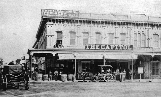
 c. late 1870s: Grand Central Hotel branded as part of the St. Charles, Bank of Los Angeles in the Pico Bldg., St. Charles hotel proper, 312 bldg. and L. Harris store, forerunner of Harris & Frank
 -
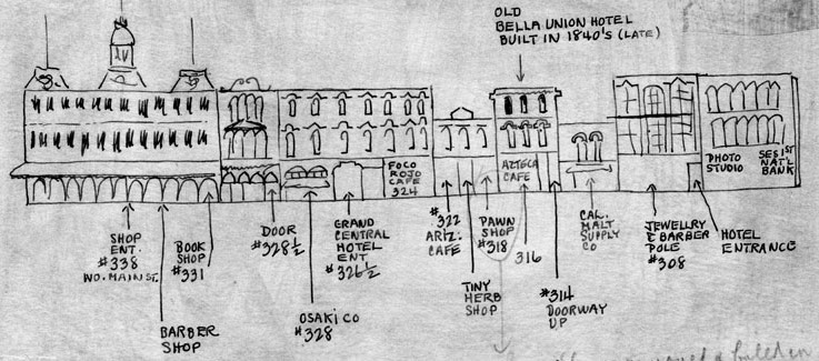 Sketch of east side of the 300 block of North Main Street, between Arcadia and Commercial streets, as it appeared circa 1880
 -
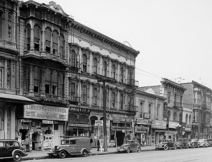 Downey ("Libería Española"), Grand Central ("Osaka Co.", "Chop Suey"), Pico ("Arizona Cafe", "Money to Loan"), Bella Union/St Charles ("Azteca"), 312 and 306-8 buildings, 1930s.
 -
 2005 view. Main St. runs along the left (west) side from the Plaza area (top left), over US 101 (site of the Baker Block) and along the western edge of the Los Angeles Mall (bottom center), site of the buildings described below (Downey Building through Ducommun Block).


South of the Baker Block stood buildings that are now the site of the northwestern-most part of the Los Angeles Mall:
- Downey Building (not to be confused with the "Downey Block"), 324–330** N. Main, opened 1878, three stories, captured in a 1957 color photo standing alone as the last building on the block, demolished that year.[24] In the 1930s photo above, it is home to the Librería Española.
- Grand Central Hotel, opened 1876, demolished.
- Pico Building, 318-322** N. Main, opened 1867, the city’s first bank building, to house the new Security Pacific National Bank. Later tenants included the Los Angeles County Bank (1874-1878), Charles H. Bush, jeweler and watchmaker (1878-1905), Louis E. Pearlson’s jewelry, loan and pawnshop (from 1905), as well as several barber shops and then a succession of owner-operated restaurants. The last occupants were a jewelers and the Mexican restaurant Arizona Cafe #2. Demolished 1957 to make way for a parking lot.[25]
- Bella Union Hotel, later the St. Charles Hotel, 314–316** N. Main. Opened 1835, demolished 1940. Home to the Azteca Cafe in the 1930s.
- 312 N. Main, two stories, home to a saloon in the mid-1890s
- 306–308 N. Main, three stories, home to offices (at #308) and Bright's Cheap Store (#306) in 1882.[26]
- Ducommun Block or Ducommun Building, 300-2-4** N. Main (200-2-4* N. Main). In the 1880s, home to the Ducommun hardware store, a furniture store and Prager Dry Goods. In the early 20th century, site of the
The Los Angeles Mall replaced these blocks; it is a small shopping center at the Los Angeles Civic Center, between Main and Los Angeles Streets on the north and south sides of Temple Street, connected by both a pedestrian bridge and a tunnel. It features Joseph Young's sculpture Triforium, with 1,500 blown-glass prisms synchronized to an electronic glass bell carillon. The mall opened in 1974 and includes a four-level parking garage with 2,400 spaces.
East side of Main from Commercial south to First
-
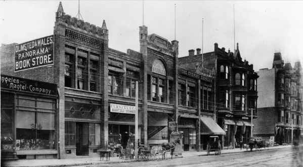
 The 1888 New Lanfranco Block, early 1920s
 -
 Main and Requena:United States Hotel right, Victorian 200–202 N. Main at left (Southern Pacificticket office in 1888)
 -
 United States Hotel, SE corner Requena/Main. c. 1880
 -
 Triforium sculpture at the Los Angeles Mall just N of the NE corner of 1st/Temple, 2018.


Currently, this site is the southernmost end of the Los Angeles Mall; Triforium is approximately on the site of Commercial Street.[29]
- #240 Farmers and Merchants Bank was located here in 1896[29]
- #236 Los Angeles Savings Bank was located here in 1896[29]
- #226-8 Commercial Bank, renamed First National Bank in 1880, was located here in 1896.[30]First National Bank was located here in 1896.[29]
- #214–222 (pre-1890 numbering: 74): New Lanfranco Block, built 1888, architects
- #200–202 (NE corner of Requena) Southern Pacific ticket office as of 1888-9[33]
- #158–172: United States Hotel, southeast corner of Main and Requena St. (a.k.a. Market St.). Built 1861-2, demolished 1939. When built it was one of three hotels in the city, alongside the Bella Union and the Lafayette Hotel. It was ornate and Italianate in style, with a "profusion of brackets, corbel tables and oriel windows. On one end, a tower with a mansard roof lit by l'oeil de boeuf windows, poked up another story to signal the hotel's location to travelers.”[34] Today, location of the south plaza of the Los Angeles Mall.
West side of Main from Temple south to First
-
 Illich's Restaurant ad from March 1890

This block is, since 1928, the site of Los Angeles City Hall
- Before 1926, Spring Street and Main Street met at Temple Street. From Temple, Main and Spring streets proceeded south; Spring at a more southwesterly angle. This created a narrow triangle with the triangle's northern point at Temple. Proceeding south along Main on the right-hand side one would pass the east side of Temple Block.
- Junction with Market Street
- Clock Tower Courthouse until demolished in 1895, or the Bullard Block built in its place after 1895.
- Junction with Court Street
- Illich's Restaurant and Oyster Parlors, 41–43 (pre-1890 numbering) 145–7 (post-1890) N. Main St.. Starting in the 1870s as a small chophouse, Illich's grew to be the largest restaurant in the city. Owner Jerry Illich was born in Dalmatia. He was connected with the Maison Doree restaurant at 4th and Main and later opened his own restaurant in 1896 on west 2nd Street between Broadway and Hill.[35]
- Northwest corner of First and Main streets.
East side of Main from First to Second
-
 TwoBaker Block.
 -
 Grand Opera House, 110 S. Main, c. 1884–1893
 -
 Orpheum Theatre when located at the Grand Opera House building, c. 1898
 -
 Forster Block


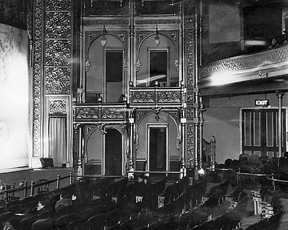
- Grand Opera House (1884, demolished 1936, capacity c. 1,300–1,800), 110 S. Main, in later years known as the Orpheum (Dec. 1894–Sep. 1903), Clune's Grand (c. 1912), The Grand (c. 1920s), and Teatro México (1930s). (The Palace Theatre). This theater was the site of the first commercial showing of motion pictures in the city, when on July 6, 1896, several films from the Edison Studios were projected by Billy Porter, who would later become a famous silent film director. Appeared in the film in Busby Berkeley's Bright Lights (1st National/Warner Bros, 1935). Demolished in 1936 to make way for a parking lot.[36]
- Forster Block, 122–128 S. Main St. (post-1890 numbering), 22–28 S. Main St. (per-1890 numbering), was a two-story building built in the early 1880s, five doors south of the Grand Opera House. It housed a coffee house of the Women's Christian Temperance Union at #26, heavily damaged in an 1885 fire, and a saddlery.[37]
Third from Spring to Main, Third and Main
-
 c. 1887 view looking east along south side of 3rd Street incl. former New York Brewery, towards Main (across top). Back left: The Thom Block. Back right: Olmsted & Wales bookstore in thePanorama Building.
 -
 Hotel Westminsterat the NE corner of 4th/Main.
._Back_left_The_Thom_Block._Back_right_-_Olmsted_%26_Wales_bookstore_in_Panorama_Building.jpg)
_and_4th,_c.1890.png)
On the corner of Third and Main:[38]
- Wells Fargo and Co. offices, northwest corner of 3rd/Main as of 1894
- The Thom Block, southeast corner of Mayo/Third and Main as of 1894
- Schwartz Block and Jackson House, southwest corner of 3rd/Main as of 1894
Buildings and sites south of Third Street
-
 Round House, west side of Main south of 3rd, c. 1880-1885
 -
Hotel Westminsterat the NE corner of 4th/Main.
-
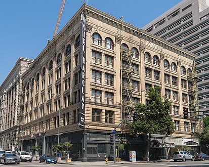 Hotel Barclay, NW corner 4th/Main
 -
 Hotel Westminster (demolished), NE corner 4th/Main, c. 1900
 -
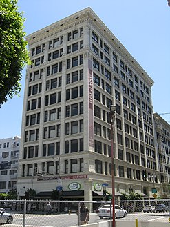
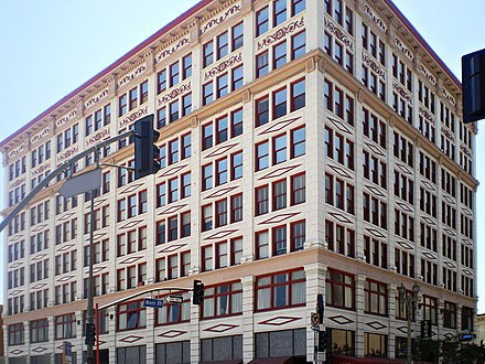 The San Fernando Building, SE corner 4th/Main, 2008
 -
 Farmers & Merchants Bank Building, SW corner 4th/Main, 2008
 -
 c. 1904, 400 block of Main looking north from 5th St. Lexington Hotel (now demolished) at #443 left; turreted Hotel Westminster, back right. Main Street Savings Bank Building at #426 (right foreground, round roof turret).
 -
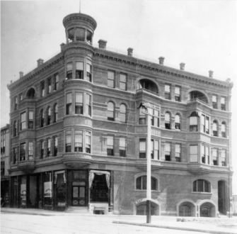 Main Street Savings Bank Building in the 1890s. NE corner of Winston. Demolished.
 -
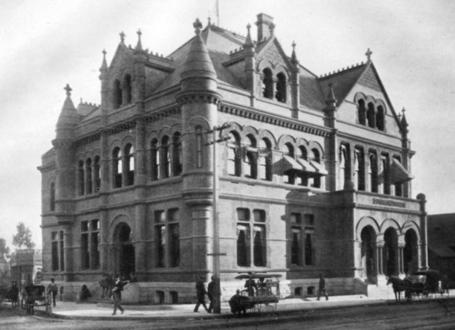 U.S. Government Building including Post Office, 1893. SE corner of Winston. Demolished.
 -
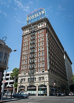 Hotel Rosslyn Annex, SW corner 5th/Main, 2017
 -
 500 block of Main south from 5th, c. 1908. Burbank Theatre at #546 at left
 -
 Kerckoff Building, 558–564 S. Main
 -
 Hotel Cecil, 640 S. Main
 -
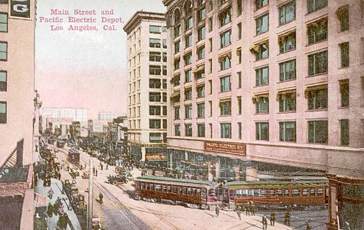 View north on Main from south of 6th, c. 1910, Pacific Electric Building at right.
 -
 Pacific Electric station at 6th and Main, c. 1905-1909
 -
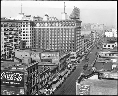 Looking north on Main from 6th c. 1917. Tall building is the Hotel Rosslyn main building. Visible: sign for Isaias W. Hellman Bldg. at 124 W. 4th; Wesley Roberts, Higgins, San Fernando and Canadian buildings. Colyear's sign is site of Hotel Rosslyn Annex.
 -
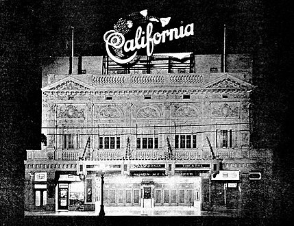 California Theatre, 810 S. Main St., Los Angeles, c. 1921
 -
 9th at Main and Spring, looking north, c. 1917. The Miller Theatre (1913) and Hotel Huntington are among the buildings in view.
 -
 9th at Main and Spring, looking north, c. 1917
.jpg)

.jpg)


.jpg)


.jpg)
.jpg)

.jpg)
.jpg)
Sources include the Clason map of Downtown Los Angeles:[39]
300 block
On the west side of Main St. south of 3rd Street were:
- #311–317 - Round House (demolished)
- 300 block west side - site of Belasco Theatre
On the east side of Main St. south of 3rd Street were:
- Panorama Building, 312–324 S. Main (post-1890 numbering), with retail shops and offices such as the Olmsted & Wales Panorama bookstore and the roller skating rink, which was unsuccessful. Owner Adolph Ramish demolished the building in 1907 and the Adolphus (later Hippodrome) Theatre was built on the site.[40] Today the site is a large open-air parking lot.[41]
- Hotel Westminsterat the end of the block, northeast corner of Fourth and Main.
4th and Main
- NW corner 4th/Main - Hotel Barclay
- NE corner 4th Main - site of Hotel Westminster, now site of Medallion Apartments
- #400–410 (SE corner of 4th/Main) - San Fernando Building
- #401 (SW corner of 4th/Main) - Farmers and Merchants Bank of Los Angeles building (former)
- #403–411 S. Main, entrance also on 124 W. 4th, Isaias W. Hellman Building (1912-5, Morgan, Walls and Morgan).[42] Not to be confused with the Hellman Buildingon Spring Street nearby.
- #420–426 (NE corner of Winston): site of Main Street Savings Bank Building, demolished
- #430 (SE corner of Winston, approximate numbering): Federal Building or Government Building, demolished. The Post Office moved here in June 1893 from 6th and Broadway.
- #443: site of Lexington Hotel[43]
5th and Main
- NW corner 5th/Main - former Rosslyn Hotel main building, now The Rosslyn lofts
- 112 W. 5th (SW corner 5th/Main) Hotel Rosslyn Annex
- SE corner 5th/Main former Charnock Block a.k.a. Pershing Hotel and Roma Hotel (508 S. Main), now New Pershing Apartments, last original two-story 19th-century commercial block left in the Historic Core.Second Empire architecture still existing in the Historic Core. The Roma was built in 1904 by Fred L. and Frank M. Lee. In 1989, both buildings were joined and renovated and are now apartments; they are contributing buildings to the "5th-Main Street Commercial Historic District", National Register of Historic Places (eligible 2007).[45]
- Burbank Theatre, 548 S. Main, opened 1893, closed 1974, demolished.[46] Now the site of the Topaz Apartments at #550.
6th and Main
- NW corner 6th/Main - site of Severance Building
- NE corner of 6th/Main, #558–564, Santa Fe Lofts also knows as the Kerckoff Building,Atchison, Topeka and Santa Fe Railroad[48]
- SW corner 6th/Main, site of Central Building
- SE corner 6th/Main, #610, Pacific Electric Railway
- #640 Hotel Cecil, 14 stories
7th and Main
- #700 Former Dearden's department store building, under renovation
- 7th to Washington: L.A. Fashion District
8th and Main
- NW corner 8th/Main, Great Republic Building, now Great Republic lofts (entrance on Spring Street)
- SW corner 8th/Main, National City Building, now National City Tower lofts
- SE corner 8th/Main Hotel Huntington Building, now Huntington Apartments
- #810, site of California Theatre (opened 1918, closed 19987, demolished 1990) and
- #842 site of the Miller Theatre (opened 1913, originally 714 seats, later 924, demolished)[49]
9th and Main
- NW corner of 9th/Main, W. M. Garland Building
- SW corner of 9th/Main Marsh & Strong Building
Theaters on Main Street

While the
- Art Theatre, 551 S. Main St.
- Banner Theatre, 458 S. Main St.
- Bijou Theatre, 553 S. Main St.
- Burbank Theatre, 548 S. Main St.
- California Theatre, 810 S. Main St.
- Clune's Theatre, 453 S. Main St.
- Crystal Theatre, 247 S. Main St.
- Denver Theatre, 238 S. Main St.
- Dohs Theatre, 166 N. Main St.
- The Downtown Independent, 251 S. Main St.
- Electric Theatre, 262 S. Main St.
- Estella Theatre, 515 N. Main St.
- Federal Theatre, 300 N. Main St.
- Follies Theatre, 337 S. Main St.
- Galway Theatre, 514 S. Main St.
- Gayety Theatre, 523 S. Main St.
- Gem Theatre, 649 S. Main St.
- Grand Opera House, 110 S. Main St. (a.k.a. Orpheum Theatre, which changed venues over the years)
- Happy Hour Theatre, 125 S. Main St.
- Hippodrome Theatre, 320 S. Main St.
- Hollander Theatre, 115 E. 1st St. ,
- Jade Theatre, 315 S. Main St.
- Lark Theatre, 613 S. Main St.
- Liberty Theatre, 266 S. Main St.
- Linda Lea Theatre, 251 S. Main St.
- Main Theatre, 438 S. Main St.
- Merced Theatre, 420 N. Main St.
- Miller's Theatre, 842 S. Main St.
- Mott's Hall, 133 S. Main St.
- Muse Theatre, 417 S. Main St.
- Nickel Theatre, 255 S. Main St.
- Novelty Theatre, 136 S. Main St.
- Olvera St. Theatre, W-10 Olvera St. / 620 N. Main St.
- Optic Theatre, 533 S. Main St.
- People's Amphitheater, N. Main St. near 1st
- Picture Theatre, 545 S. Main St.
- Playo Theatre, 349 N. Main St.
- Plaza Theatre, 224 N. Main St.
- Princess Theatre, 121 W. 1st St.
- Principal Theatre, 433 N. Main St.
- Regal Theatre, 323 S. Main St.
- Regent Theatre, 448 S. Main St.
- Republic Theatre, 629 1/2 S. Main St.
- Rex Theatre, 324 S. Main St.
- Roosevelt Theatre, 212 N. Main St.
- Rosslyn Theatre, 431 S. Main St.
- Rounder Theatre, 510 S. Main St.
- Sherman Theatre, 518 S. Main St.
- Star Theatre, 529 S. Main St.
- Star Theatre, 100 block of E. 5th St.
- Stearns Hall, SE corner N. Main St. and Arcadia St.
- Tally's Phonograph and Vitascope Parlor, 137 S. Main St.
- Teatro Hidalgo, 373 N. Main St.
- Teatro Torito, W-12 Olvera St. / 622 N. Main St.
- Temple Theatre, 155 N. Main St.
- Victor Theatre, 1718 S. Main St.
- Wood's Opera House, 410 N. Main St.
Transportation
Main Street carries
References
- ^ "Google Maps". Retrieved 7 March 2022.
- ^ Map showing Main Street downtown
- ^ Lois Ann Woodward (1936). "Merced Theater" (PDF). State of California, Department of Natural Resources.
- ^ Rose L. Ellerbe (1925-10-25). "City's Progress Threatens Ancient Landmarks: Structures Once City's Pride Now Hidden in Squalor". Los Angeles Times.
- ^ "Plaza House", Library of Congress
- ^ "Plaza House", Water and Power Associates
- ^ "LA Plaza de Cultura y Artes, Vickrey-Brunswig Building", Los Angeles Conservancy
- ^ Louis Sentous biography, Bridge to the Pyrenees
- ^ "San Fernando Theatre", Los Angeles Theatres
- ^ plate 003 of the 1910 Baist Real Estate Survey
- ^ "Lafayette Hotel", Water and Power Associates
- ^ "Federal Site's Razing Starts". Los Angeles Times. February 10, 1933. p. 32.
- ^ "The Farmers' and Merchants' Bank". Los Angeles Herald. June 14, 1874. p. 3.
- ^ "Farmers and Merchants Bank", Water and Power Associates
- ^ "The Jacoby Brothers: Pioneer Jewish Merchants of Los Angeles". Jewish Museum of the American West. Retrieved 16 May 2019.
- ISBN 9780520275508.
- ^ "Maurice Kremer: Very Early Pioneer Jewish Merchant and Civil Servant of Los Angeles". Jewish Museum of the American West. Retrieved April 9, 2018.
- ^ Knapp, Dan "A Retail History on the Shelf", USC News, November 12, 2010, University of Southern California. Retrieved April 30, 2019
- ^ "Legal notice". Los Angeles Express. February 15, 1878. p. 2.
- ^ "Advertisement by L. Harris/Quincy Hall". Los Angeles Herald. October 24, 1879. p. 2. Retrieved 6 May 2019.
- ^ a b General Services Administration page on the United States Court House (Los Angeles).
- ^ "The Baker Block". Los Angeles Evening Express. February 11, 1879.
- ^ "Baker Block", Water and Power Associates
- ^ "North Main Street building at the 101 Freeway coming down soon", Huntington Digital Library
- ^ https://www.newspapers.com/clip/59823326/pico-building-razed/
- ^ 1882 photo of east side of Main Street, "Early City Views", Water and Power Associates
- ^ “Ducommun Building”, Water and Power Associates
- ^ "Federal Theatre", Los Angeles Theaters
- ^ a b c d e Plate 14, vol. 1 of 1896 Sanborn Fire Map of Los Angeles, via Library of Congress
- ^ "Main Street", Calisphere
- ^ "Lanfranco Block", Romanesque Revival Downtown
- ^ "To Be Replaced". Los Angeles Herald. January 15, 1888. p. 9.
- ^ Ad, p.7, Los Angeles Times, March 27, 1888
- ^ “United States Hotel”, Pacific Coast Architecture Database
- ^ "Jerry Illich" in the Annual Publication of the Historical Society of Southern California and of the Pioneers of Los Angeles County (1902) 5 (3): 309.
- ^ "Grand Opera House", Los Angeles Theatres
- ^ "Fire: A quick, hot blaze on Main Street". Los Angeles Mirror. October 24, 1885.
- ^ Sanborn 1894 map of Los Angeles, vol. 1, plate 9
- ^ 1924 Clason map of Downtown Los Angeles
- ^ "Panoramas in Los Angeles", The Velaslavasay Panorama
- ^ "Joe's Auto Parks Parking", Google Maps
- ^ Hellman, Isaias W., Office Building, Los Angeles, CA (1912-1915)
- ^ [digitallibrary.usc.edu/cdm/ref/collection/p15799coll65/id/2147 "Exterior view of the Lexington Hotel on Main Street, looking south from Winston Street, ca.1905", USC Digital Library]
- ^ "Victorian Victory at the New Pershing", Los Angeles Downtown News
- ^ "Charnbock Block/Pershing Hotel and "Roma Hotel" Calisphere, University of California
- ^ "Burbank Theatre", Los Angeles Theatres
- ^ "Kerckhoff Building", PCAD
- ^ "Historic high-rise sold as downtown L.A.'s former business district thrives". 31 March 2018.
- ^ "Millers Theatre", Los Angeles Theatres
- ^ "Main Street and further east", ''Los Angeles Theatres''
- ^ "N Main St & N Vignes St · Los Angeles, CA 90012". N Main St & N Vignes St · Los Angeles, CA 90012. Retrieved 2023-05-21.
- ^ "Alameda St & N Main St · Los Angeles, CA 90012". Alameda St & N Main St · Los Angeles, CA 90012. Retrieved 2023-05-21.