
Malerkotla
This article needs additional citations for verification. (January 2016) |
Malerkotla | |
|---|---|
City | |
UTC+5:30 (IST) | |
| PIN | 148023 |
| Vehicle registration | PB-28 |
| Website | www |
Malerkotla is a city and the district headquarters of
When PEPSU was reorganised in 1956, the territories of the erstwhile state of Malerkotla became part of Punjab.[2] It is situated on the Sangrur-Ludhiana State Highway (no. 11) and lies on the secondary Ludhiana-Delhi railway line. It is about 50 kilometres (31 mi) from Ludhiana and 35 kilometres (22 mi) from Sangrur.
In 2021, the city along with some adjoining areas were carved out of Sangrur district to form the Malerkotla district.[3]
History
Malerkotla, a Muslim majority state was established in 1454 by Sheikh Sadruddin-i-Jahan from Afghanistan,[4] and was ruled by his Sherwani descendants. The State of Malerkotla was established in 1600 A.D. During the 1947 riots when Punjab was experiencing heavy amounts of communal violence, the State of Malerkotla remained relatively peaceful.[4]
The roots of communal harmony date back to 1705, when
Under British colonial rule, a Namdhari uprising was suppressed, and the colonial government ordered execution of 65 captured rebels and those thought to be involved with the rebellion. Cowan (the Deputy Commissioner of Ludhiana) and Forsyth (the Commissioner of Ambala) ordered the Namdharis to be executed with cannons, without any trial, on 17 and 18 January 1872.[5]
During the partition of India, there were no riots or bloodshed in any part of Maler Kotla State. The last Nawab Iftikhar Ali Khan of Malerkotla maintained calm and harmony during the turbulent period. He remained in India and died in the year 1982. His tomb is located in Shahi grave yard situated at Sirhandi gate, Maler Kotla. Many also attribute this peace to the presence of the shrine of Baba Haidar Sheikh, the Sufi saint, who founded the town of Malerkotla more than 500 years ago.[6][7]
A part of the ruling family of Sheikh Sadr-ud-Din Sherwani migrated to Pakistan and lived mostly in Model Town, Lahore, Muzzafargarh, Khangarh.[8]
Malerkotla is famous for its vegetables and badge-making industry,[9] besides its poets and monuments.[10]
Demographics
As per provisional data of 2011 census Malerkotla urban agglomeration had a population of 189,424, out of which males were 82,376 and females were 64,048 . The literacy rate was 70.25 per cent.[11]
Malerkotla is the only Muslim-majority city of Punjab.[12]
| Religious group |
1881[15][16]: 520 [17]: 250 | 1891[18]: 68 [19] | 1901[20]: 44 [21]: 26 | 1911[22]: 23 [23]: 19 | 1921[24]: 25 [25]: 21 | 1931[26]: 26 | 1941[14]: 32 | 2011[27] | ||||||||
|---|---|---|---|---|---|---|---|---|---|---|---|---|---|---|---|---|
| Pop. | % | Pop. | % | Pop. | % | Pop. | % | Pop. | % | Pop. | % | Pop. | % | Pop. | % | |
| Islam |
14,468 | 70.16% | 15,520 | 71.34% | 15,056 | 71.28% | 15,666 | 65.6% | 16,599 | 67.57% | 18,449 | 73.09% | 22,296 | 76.04% | 92,765 | 68.5% |
| Hinduism |
4,584 | 22.23% | 4,961 | 22.81% | 4,673 | 22.12% | 5,801 | 24.29% | 6,701 | 27.28% | 5,246[b] | 20.78% | 6,270[b] | 21.38% | 28,044 | 20.71% |
| Jainism |
1,242 | 6.02% | 1,227 | 5.64% | 1,331 | 6.3% | 1,244 | 5.21% | 583 | 2.37% | 1,240 | 4.91% | 259 | 0.88% | 1,499 | 1.11% |
| Sikhism |
324 | 1.57% | 37 | 0.17% | 51 | 0.24% | 1,155 | 4.84% | 668 | 2.72% | 269 | 1.07% | 456 | 1.56% | 12,864 | 9.5% |
| Christianity |
— | — | 9 | 0.04% | 11 | 0.05% | 14 | 0.06% | 13 | 0.05% | 36 | 0.14% | 39 | 0.13% | 172 | 0.13% |
| Buddhism |
— | — | 0 | 0% | 0 | 0% | 0 | 0% | 0 | 0% | 0 | 0% | — | — | 26 | 0.02% |
| Others | 3 | 0.01% | 0 | 0% | 0 | 0% | 0 | 0% | 0 | 0% | 0 | 0% | 1 | 0% | 54 | 0.04% |
| Total population | 20,621 | 100% | 21,754 | 100% | 21,122 | 100% | 23,880 | 100% | 24,564 | 100% | 25,240 | 100% | 29,321 | 100% | 135,424 | 100% |
Education

Urdu is taught alongside Punjabi in Malerkotla schools due to the local Punjabi Muslim majority.[citation needed]
Nawab Sher Mohammad Khan Institute of Advanced Studies in Urdu, Persian and Arabic is part of
There are many schools and institutes including Learning Cottage Of Commerce. There are other schools like Sohrab Public Senior Secondary School, Al Falah Public senior secondary School, the town school, Sahibzada Fateh Singh senior secondary public school, Sita grammar school, Sarvhitkari Vidya Mandir, Modern Secular school, DAV public school and many more. Almighty Public School on Almighty School road, Jamalpura, Malerkotla is a co-education, English Medium Sr. Secondary School. This school provide Education about Islam for Muslim students.
Transportation
Rail
Malerkotla is situated on Delhi-Jakhal-Dhuri-Ludhiana Railway line. The nearest railway junctions are Dhuri (18 km [11 mi]) and Ludhiana 45 km [28 mi]).
Air
The nearest airports to Malerkotla are:
- Chandigarh Airport, also known as Shaheed Bhagat Singh International Airport, Sahibzada Ajit Singh Nagar, Mohali (about 120 km (75 mi) away)
- Sri Guru Ram Dass Jee International Airport, Amritsar (about 250 km (160 mi) away)
- Sahnewal Airport (IATA: LUH, ICAO: VILD), also known as Ludhiana Airport (about 49.8 km (30.9 mi) (66min) away)
Notable residents
- Iftikhar Ali Khan of Malerkotla (Last Nawab of Malerkotla)
- Anas Rashid (Indian television actor)
- Irshad Kamil (Indian lyricist and poet)
- Mohammad Nazim (Indian television actor)
- Razia Sultana (politician) (Indian Politician)
- Saeed Jaffrey (Indian actor)
- Ahmad Ali Khan of Malerkotla (Malerkotla Nawab)
- Channi Singh (Indian musician)
- Zeenat Begum (Pakistani singer)
- Bobby Jindal (American politician, 55th Governor of Louisiana)
- Mohammad Sajid Dhot (Indian footballer)
- Dr. Mohammad Jamil Ur Rahman (politician from Aam Aadmi Party)
Gallery
-
 Gurudwara Sahib Haaw Da Naara
 -
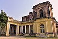 Mubarak Manzil Palace
 -
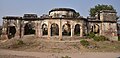 Qila
Qila -
 Railway station
 -
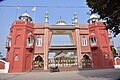 Eidgah


Notes
- ^ 1881-1941: Data for the entirety of the town of Malerkotla, which included Malerkotla Municipality and Malerkotla Civil Lines.[14]: 32
- ^ a b 1931-1941: Including Ad-Dharmis
References
- ISSN 0971-751X. Retrieved 14 May 2021.
- ^ Malerkotla Punjab at www.india9.com.
- ^ "District Malerkotla, Government of Punjab | Welcome to District Web Portal of Malerkotla | India". Retrieved 15 September 2022.
- ^ The Tribune. Retrieved 24 March 2013.
- ^ Rebels Against the British Rule (1995). Bhai Nahar Singh & Bhai Kirpal Singh. Atlantic Publishers & Distributors; Page XXI
- ISBN 978-0-8026-0761-4.
- The Tribune. Retrieved 24 March 2013.
- ^ Malerkotla Muslims.. Archived 2 September 2009 at the Wayback Machine The India Express, August 14, 1997.
- The Tribune. Retrieved 24 March 2013.
- The Tribune. Retrieved 24 March 2013.
- ^ "Urban Agglomerations/Cities having population 1 lakh and above" (PDF). Provisional Population Totals, Census of India 2011. Retrieved 7 July 2012.
- ^ "Explained: Why is Malerkotla special for Punjab, and Sikhs?". The Indian Express. 22 May 2021. Retrieved 26 April 2022.
- ^ "Malerkotla City Population Census 2011 - Punjab".
- ^ a b "CENSUS OF INDIA, 1941 VOLUME VI PUNJAB". Retrieved 9 January 2024.
- JSTOR saoa.crl.25057656. Retrieved 14 January 2024.
- JSTOR saoa.crl.25057657. Retrieved 14 January 2024.
- JSTOR saoa.crl.25057658. Retrieved 20 January 2024.
- JSTOR saoa.crl.25318666. Retrieved 9 January 2024.
- JSTOR saoa.crl.25318669. Retrieved 9 January 2024.
- JSTOR saoa.crl.25352838. Retrieved 9 January 2024.
- JSTOR saoa.crl.25363739. Retrieved 9 January 2024.
- JSTOR saoa.crl.25393779. Retrieved 9 January 2024.
- JSTOR saoa.crl.25393788. Retrieved 9 January 2024.
- JSTOR saoa.crl.25394121. Retrieved 9 January 2024.
- JSTOR saoa.crl.25430165. Retrieved 9 January 2024.
- ^ "CENSUS OF INDIA, 1931 VOLUME XVII PUNJAB PART II TABLES". Retrieved 9 January 2024.
- ^ "C -1 POPULATION BY RELIGIOUS COMMUNITY - 2011". census.gov.in. Retrieved 20 January 2024.
- ^ "Urdu academy for Malerkotla". The Indian Express. 20 January 1999.[permanent dead link]
Further reading
- Kinship and the Political Order: The Afghan Sherwani Chiefs of Malerkotla (1454–1947), Contributions to Indian Sociology, Vol. 28, No. 2, 203–241 (1994).
External links
| International | |
|---|---|
| National | |