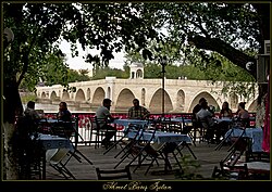
Meriç Bridge
Meriç Bridge Meriç Köprüsü | |
|---|---|
 Meriç Bridge over the Meriç in Edirne. | |
| Coordinates | 41°39′48″N 26°33′08″E / 41.66326°N 26.55210°E |
| Crosses | Meriç |
| Locale | Edirne, Turkey |
| Other name(s) | Yeni Köprü (New Bridge) Mecidiye Köprüsü (Mecidiye Bridge) |
| Characteristics | |
| Material | Stone |
| Total length | 263 m (863 ft) |
| Width | 7 m (23 ft) |
| No. of spans | 12 |
| History | |
| Construction end | 1843 |
| Location | |
 | |
Meriç Bridge (Turkish: Meriç Köprüsü), a.k.a. Yeni Köprü, meaning New Bridge or Mecidiye Bridge, after Sultan Abdülmecid I, is a historic Ottoman bridge in Edirne (formerly Adrianople), Turkey. It crosses the Meriç river,[1] formerly carrying the state road ![]() D.100, connecting Pazarkule border gate through Karaağaç to Edirne. It has since been bypassed by Dr. Mehmet Müezzinoğlu Bridge.
D.100, connecting Pazarkule border gate through Karaağaç to Edirne. It has since been bypassed by Dr. Mehmet Müezzinoğlu Bridge.
Construction of the bridge began under the Ottoman sultan
Abdülmecid I (r. 1839–1861). The 263-metre-long (863 ft) and 7-metre-wide (23 ft) bridge has twelve arches.[1]
References
- ^ ISBN 9781845645069.
External links
Wikimedia Commons has media related to Meriç Bridge.
