
Mersa Matruh
Mersa Matruh
مرسى مطروح | |
|---|---|
City | |
.jpg)       | |
|
UTC+2 (EST) | |
| Area code | (+20) 46 |
Mersa Matruh (
the Western Desert towards Siwa Oasis and Bahariya Oasis
.
Mersa Matruh was a major
British Empire. During World War II, several battles were fought around its environs as the Italo-German Panzer Army Africa attempted to capture the port. It fell to the Axis during the Battle of Mersa Matruh but was recaptured following the Second Battle of El Alamein
.
Mersa Matruh is served by
Mersa Matruh International Airport. The city features soft white sand beaches and calm transparent waters; the bay is protected from the high seas by a series of rocks forming a natural breakwater
, with a small opening to allow access for light vessels.
History
Mersa Matruh began as a small fishing town but was important enough to host an
Amun Ra at the Siwa Oasis
.
It became known as Ammonia (
Koinē Greek: Παραιτόνιον, Paraitónion; Coptic: ⲧⲡⲁⲣⲁⲧⲟⲛⲓⲟⲛ, Tparatonion).[4] It served as a major transit port for Egyptian grain to Rome. Ovid wrote that its patron goddess during his era was Isis.[5]
The city was
Christianized by the 6th century, when a chapel was built in the Byzantine style.[6]
After the 7th-century
Arabic: البارتون, al-Bāritūn). The city also bore other names from at least the beginning of the 20th century: Berek Marsa, Port Mhaddra (Mithr), and Port Bardiah.[7]
During
railway, which passed through El Alamein. Mersa Matruh served as a vital British military base during World War II and was a major objective of Erwin Rommel's Afrika Korps, which captured it during the Battle of Mersa Matruh
.
During the
Abdel Fattah El-Sisi turned into Anti-Sisi protests with protesters burning photos of El-Sisi and chanting chants against him.[citation needed
]
Geography
Climate
Mersa Matruh has a dry-summer
wet. Summers are sunny and see little rainfall, while in the colder months, there is some rain and cloud cover. Sleet and hail are common in winter.[citation needed
]
Mersa Matruh and
Kafr el-Dawwar and Mersa Matruh are the wettest in Egypt
.
| Climate data for Mersa Matruh (Marsa Matruh International Airport) 1991–2020 normals, extremes 1920–present | |||||||||||||
|---|---|---|---|---|---|---|---|---|---|---|---|---|---|
| Month | Jan | Feb | Mar | Apr | May | Jun | Jul | Aug | Sep | Oct | Nov | Dec | Year |
| Record high °C (°F) | 30.6 (87.1) |
34.0 (93.2) |
40.0 (104.0) |
43.5 (110.3) |
44.1 (111.4) |
46.2 (115.2) |
45.0 (113.0) |
43.0 (109.4) |
42.5 (108.5) |
39.3 (102.7) |
36.7 (98.1) |
29.2 (84.6) |
46.2 (115.2) |
| Mean daily maximum °C (°F) | 18.1 (64.6) |
18.7 (65.7) |
20.5 (68.9) |
23.2 (73.8) |
25.7 (78.3) |
28.2 (82.8) |
29.9 (85.8) |
30.5 (86.9) |
29.7 (85.5) |
27.3 (81.1) |
23.5 (74.3) |
19.7 (67.5) |
24.5 (76.1) |
| Daily mean °C (°F) | 13.5 (56.3) |
14.0 (57.2) |
15.7 (60.3) |
18.1 (64.6) |
20.9 (69.6) |
24.1 (75.4) |
26.1 (79.0) |
26.7 (80.1) |
25.6 (78.1) |
23.0 (73.4) |
18.9 (66.0) |
15.2 (59.4) |
20.2 (68.4) |
| Mean daily minimum °C (°F) | 9.5 (49.1) |
9.6 (49.3) |
11.1 (52.0) |
13.3 (55.9) |
16.2 (61.2) |
19.7 (67.5) |
22.1 (71.8) |
22.7 (72.9) |
21.4 (70.5) |
18.6 (65.5) |
14.6 (58.3) |
11.2 (52.2) |
15.8 (60.4) |
| Record low °C (°F) | 1.0 (33.8) |
2.0 (35.6) |
2.2 (36.0) |
5.0 (41.0) |
7.8 (46.0) |
9.8 (49.6) |
12.9 (55.2) |
17.0 (62.6) |
10.0 (50.0) |
0.0 (32.0) |
6.0 (42.8) |
0.0 (32.0) |
0.0 (32.0) |
| Average precipitation mm (inches) | 35.8 (1.41) |
21.2 (0.83) |
7.9 (0.31) |
3.0 (0.12) |
1.5 (0.06) |
0.2 (0.01) |
0.1 (0.00) |
0.2 (0.01) |
0.6 (0.02) |
9.3 (0.37) |
21.4 (0.84) |
32.4 (1.28) |
132.9 (5.23) |
| Average precipitation days (≥ 1.0 mm) | 5.7 | 4.9 | 1.7 | 1.0 | 0.5 | 0.6 | 0.0 | 0.0 | 0.2 | 1.3 | 2.5 | 4.6 | 23.0 |
| Average relative humidity (%)
|
71 | 69 | 68 | 66 | 73 | 73 | 75 | 73 | 71 | 70 | 68 | 69 | 70.5 |
| Average dew point °C (°F) | 7.2 (45.0) |
7.4 (45.3) |
8.5 (47.3) |
10.7 (51.3) |
14.5 (58.1) |
17.5 (63.5) |
19.9 (67.8) |
20.2 (68.4) |
18.4 (65.1) |
15.5 (59.9) |
11.7 (53.1) |
8.3 (46.9) |
13.3 (55.9) |
| Mean monthly sunshine hours | 196.3 | 214.5 | 254.1 | 269.1 | 316.7 | 355.4 | 371.9 | 356.3 | 309.2 | 268.2 | 222.2 | 196.6 | 3,330.5 |
| Source 1: NOAA (humidity, dew point, sun 1961–1990)[9][10] | |||||||||||||
| Source 2: Meteo Climat (record temperatures)[11] | |||||||||||||
| Jan | Feb | Mar | Apr | May | Jun | Jul | Aug | Sep | Oct | Nov | Dec |
|---|---|---|---|---|---|---|---|---|---|---|---|
| 18 °C (64 °F) | 17 °C (63 °F) | 17 °C (63 °F) | 18 °C (64 °F) | 20 °C (68 °F) | 23 °C (73 °F) | 25 °C (77 °F) | 26 °C (79 °F) | 26 °C (79 °F) | 25 °C (77 °F) | 22 °C (72 °F) | 20 °C (68 °F) |
Main sights
- Ruins of the Temple of the King, Pharaoh Ramesses II (1200 BC)
- Drowned city of Caesar.
- Drowned Palace of Cleopatra.
- Egyptian Fleet Anchorage which was built by the Ptolemies. The remains of the naval installations still stand west of the port.
- Coptic Chapel: built in the early Coptic age, it contains several caves bearing inscriptions.
- Rommel's Hideout: a cave, hewn in the rock, where Rommel drew up plans for his military operations. It has now been turned into a military museum.
- The British Cemetery: thousands of rock-hewn tombstones stand in straight rows amidst a fenced garden.
- The German Cemetery: a fortress-like memorial that was built on a height overlooking the sea.
- The Italian Cemetery: a high tower fort standing on a high hill. The walls of the building are covered with marble.
- Matrouh Archaeology Museum
Main beaches
- Ageebah Beach: About 28 km west of Mersa Matruh downtown, distinguished by its numerous natural caves
- Al-Obayed Beach: About 20 km west of downtown Mersa Matruh
- Rommel Bay
Photo gallery
-
 Mural in front of the Matrouh Governorate building
 -
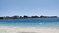
 The corniche
 -
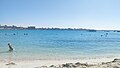
 City beaches
 -
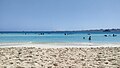
 Rommel Beach
 -
 El Gharam Beach ("Love Beach") (1)
 -
 El Gharam Beach ("Love Beach") (2)
 -
 Al-Awam mosque
 -
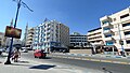
 Governorate building


See also
References
Wikimedia Commons has media related to Mersa Matruh.
- ^ a b c "Marsā Maṭrūḥ (Kism (urban and rural parts), Egypt) - Population Statistics, Charts, Map and Location". citypopulation.de. Retrieved 17 June 2023.
- ^ Dictionary of Greek and Roman Geography (1854), Paraetonium
- ^ Strabo, Geography, 17.1
- ^ George of Cyprus (1890). Georgii Cyprii Descriptio orbis romani. Cornell University: B. G. Teubneri. p. 142.
- ^ "ToposText". topostext.org. Retrieved 2019-12-30.
- JSTOR 40000580.
- ISBN 978-81-7268-011-4.
- ^ Playfair, Vol. I, page 3.
- ^ "Mersa Matruh Airport Normals 1991–2020". World Meteorological Organization Climatological Standard Normals (1991–2020). National Oceanic and Atmospheric Administration. Archived from the original on 3 October 2023. Retrieved 3 October 2023.
- ^ "Mersa Matruh (A) Normals 1961–1990". National Oceanic and Atmospheric Administration. Archived from the original on October 3, 2023. Retrieved October 3, 2023.
- ^ "Station Mersa Matruh" (in French). Meteo Climat. Retrieved 3 October 2023.
- ^ "Marsa Matruh Climate and Weather Averages, Egypt". Weather to Travel. Retrieved 13 July 2013.
- Falling Rain Genomics, Inc. "Geographical information on Marsa Matruh, Egypt". Retrieved 2008-03-23.
External links
Sources
- ISBN 978-1-84574-065-8.
| International | |
|---|---|
| National | |
| Geographic | |
| Other | |