
Mount Haeckel
| Mount Haeckel | |
|---|---|
 North face | |
| Highest point | |
| Elevation | 13,424 ft (4,092 m)[1] |
| Prominence | 498 ft (152 m)[1] |
| Parent peak | Mount Fiske[1] |
| Isolation | 1.07 mi (1.72 km)[2] |
| Listing |
|
| Coordinates | 37°09′04″N 118°39′40″W / 37.1509924°N 118.6610067°W[3] |
| Naming | |
| Etymology | Ernst Haeckel |
| Geography | |
 Mount Haeckel  Mount Haeckel | |
| Location |
|
Mount Haeckel is a 13,424-foot (4,092 m) mountain summit located on the crest of the Sierra Nevada mountain range in northern California, United States.[3] It is situated on the shared boundary of Kings Canyon National Park with John Muir Wilderness, and along the common border of Fresno County with Inyo County. It is 21.5 miles (34.6 km) west of the community of Big Pine, 1.27 miles (2.04 km) south-southeast of Mount Darwin, and one mile north-northeast of Mount Fiske, which is the nearest higher neighbor. Mount Haeckel ranks as the 71st highest summit in California.[2]
History
In 1895,
On July 14, 1920, Walter L. Huber led a Sierra Club party of nine climbers to the first ascent of the summit via the West Shoulder.[7] A few minutes later, Edward O. Allen, Francis E. Crofts, and Olcott Haskell arrived via the South Ridge.[8] This second Sierra Club party was surprised that they were not on Mount Darwin, their intended destination.[9]
Climbing
Established climbing routes on Mount Haeckel:[10]
- West Shoulder – class 3– First Ascent 1920
- South Ridge – class 3 – FA 1920
- North Face – class 3 – FA 1933 by Jack Riegelhuth
- Northeast Ridge – class 4 – FA 1935
The Northwest Arête is considered one of the classic climbing routes in the Sierra Nevada.[11]
Climate
According to the
Gallery
-
 Mt. Haeckel centered
 -
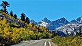 Heackel centered, from Highway 168, (the road to Lake Sabrina)
 -
 Haeckel left of center, from Lake Sabrina
 -
 Haeckel in upper right corner in back.
Picture Peak centered, from Sailor Lake -
 Southeast aspect of Haeckel from Mt. Wallace. Mt. Darwin behind, right
 -
 circa early 1920s


See also
 Mountains portal
- List of the major 4000-meter summits of California
- Mount Wallace
References
- ^ a b c d "Mount Haeckel, California". Peakbagger.com. Retrieved 2021-04-18.
- ^ a b c "Haeckel, Mount". ListsOfJohn.com. Retrieved 2021-04-18.
- ^ a b "Mount Haeckel". Geographic Names Information System. United States Geological Survey, United States Department of the Interior. Retrieved 2021-04-18.
- ^ Francis Peloubet Farquhar, Exploration of the Sierra Nevada, 1925, California Historical Society, page 47.
- ISBN 0-89997-119-9.
- ISBN 9780899970479, page 89.
- ^ Walter L. Huber, First Ascent of Mount Haeckel, Sierra Club Bulletin, Vol. XI, 1923, page 145.
- ^ Francis P. Farquhar, Place Names of the High Sierra (1926)
- ^ Alan M. Hedden and David R. Brower, A Climber's Guide to the High Sierra (1954)
- ^ Alan M. Hedden and David R. Brower, A Climber's Guide to the High Sierra (1954)
- ISBN 9780934641609.
- ISSN 1027-5606.
External links
- Weather forecast: Mount Haeckel
- Account of first ascent: Sierra Club Bulletin
- Mt. Haeckel Rock Climbing: Mountainproject.com