
Mount Nimba Strict Nature Reserve
| Mount Nimba Strict Nature Reserve | |
|---|---|
Côte d'Ivoire | |
| Nearest city | Yekepa, Bossou, N'Zoo |
| Coordinates | 7°38′16″N 8°25′14″W / 7.6377578°N 8.4206111°W |
| Area | 175.4 km2 (43,300 acres) |
| Established | 1944 |
| Type | Natural |
| Criteria | ix, x |
| Designated | 1981 (5th session) |
| Reference no. | 155 |
| Region | Africa |
| Endangered | 1992–present |
| Extension | 1982 |
Mount Nimba Strict Nature Reserve (French: Réserve naturelle intégrale du Mont Nimba) is a protected area and UNESCO World Heritage Site located in both Guinea and Côte d'Ivoire, extending over a total of area of 175.4 km2 (43,300 acres), with 125.4 km2 (31,000 acres) in Guinea, and 50 km2 (12,000 acres) in Côte d'Ivoire. The reserve covers significant portions of the Nimba Range, a geographically unique area with unusually rich flora and fauna, including exceptional numbers of single-site endemic species, such as Nimbaphrynoides (a genus of viviparous toads), the Nimba otter shrew, and multiple species of horseshoe bats.[1] Its highest peak is Mount Richard-Molard at 1,752 m (5,750 ft), which is the highest peak of both countries.
History
The strict nature reserve was established in 1943 by Order No. 4190 SE/F in Côte d'Ivoire and in 1944 by decree in Guinea. The Guinean part was accepted as a biosphere reserve in 1980. Both reserves were combined to form one World Heritage Site in 1981 (Guinea) and 1982 (Côte d'Ivoire) because of its outstanding biodiversity and unique mosaic of tropical habitats.[1] Iron-ore exploration for mining in the most vulnerable montane zone started in 1992, and the reserve has been listed as a World Heritage Site in danger since then.[1] For the sake of an improved protection, a conservation management centre is being built by Guinean Parks Foundation. The project was approved by the Guinean Government and CEGENS in 2016.
Geography
The Nimba Range is a narrow ridge extending approximately 40 km long, with an orientation of northeast–southwest; it forms a part of the southern extent of the Guinea Highlands. Its highest peak is Mount Richard-Molard at 1,752 m (5,750 ft). Other peaks include Grand Rochers at 1694 m (5558 ft), Mont Sempéré at 1682 m (5518 ft), Mont Piérré Richaud at 1670 m (5479 ft), Mont Tô at 1675 m (5495 ft), and Mont LeClerc 1577 m (5174 ft). All of them are located in the Guinean part of the reserve. There are about fifty springs, including the origins of the Cavally, Cestos, and Sassandra Rivers. Mining of top-quality iron-ore poses the major threat to the unique geomorphology and wildlife.
Climate
The
Ecology

Mount Nimba Strict Nature Reserve lies within the
Terrestrial
Terrestrial vegetation varies with altitude and cardinal orientation.
- The mountain is isolated from other Guinean forest-savannah mosaic. Savanna habitats are broken by gallery forestsand closed canopy forest islands.
- The lowland foothills are covered by the Western Guinean Lowland Forest up to 600 meters. The characteristic forest type is semi-deciduous high forest with a main canopy and an emergent layer. There are 40-70 tree species found in a single hectare, and up to 500 forest tree species recorded in the area.
- Guinean Montane Forests are located between 600 and 1200–1400 meters. At lower levels, semi-deciduous high forests extend up to 900 meters; they are poorer in species compared to lowlands. Short dry forests can be found in the eastern end of the ridge. From 900 meters altitude, where the mountain is covered by clouds almost most of the year, mossy forests are present, which can be divided into three types: Parinari exclesa forests (1), summit forests (2), and tree fern forests in the valleys where groundwater is abundant (3). Above the tree zone, there is a transition of Protea bushland to grassland.
- Isolated high-altitude grassland extends from 1200 to 1400 meters to the highest peaks. There, the most famous endemic vertebrates are the Nimba viviparous toad (Nimbaphrynoides occidentalis), and the Lamotte's roundleaf bat (Hipposideros lamottei), the latter recorded from only one mining site. Endemic plants include among others Asplenium schnellii, Osbeckia porteresii and Blaeria nimbana.
Tourism
Mount Nimba lies in a remote region along the tri-national border of Guinea, Côte d'Ivoire, and Liberia, far from their capital cities. In fact, the Liberian third of the ridge is seriously degraded, thanks to the former intense mining, while the Guinean part has remained ecologically intact and natural.
Trivia
One of the four honey buzzards of Kempen-Broek that are equipped with GPS trackers passed this national park on 13 November 2013.[3]
Gallery
-
 Border of the reserve (Gbakore)
 -
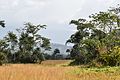 Lowland savanna around Mount Nimba
 -
 Lowland rainforest
 -
 Western chimpanzees
 -
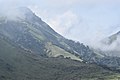 Montane cloud forest
 -
 Montane Protea bushland
 -
 Montane grassland
 -
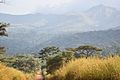
 A tourist above clouds


See also
References
- ^ a b c d e f "Mount Nimba Strict Nature Reserve". UNESCO World Heritage Convention. Retrieved 10 December 2022.
- ^ "Freshwater Ecoregions Of the World". www.feow.org. Retrieved 2016-12-19.
- ^ "Wespendieven van het Kempenbroek".
External links
- Official website of the Guinean Mount Nimba Strict Nature Reserve
- UNESCO Mount Nimba Strict Nature Reserve Site
- Mount Nimba Strict Nature Reserve, Guinea and Côte d'Ivoire (UNESCO MAB Biosphere Reserves Directory)
- Mount Nimba Strict Nature Reserve, Guinea and Côte d'Ivoire (African World Heritage Sites)
- Mount Nimba Strict Nature Reserve, Guinea and Côte d'Ivoire (Encyclopedia of Earth)
- Mount Nimba (Freshwater Ecoregions of the World)
- APES MAPPER
- WCMC Natural Site Data Sheet
- Act Establishing East Nimba Nature Reserve - Republic of Liberia
- Guinean Safari Services