
Mud (village)
Mud
Mudh, Muth | |
|---|---|
Village | |
UTC+5:30 (IST ) |
Mud (also known as Mudh and Muth) is a small village in the cold desert region of
Mud became famous among geologists in the 1860s when the Moravian geologist Ferdinand Stoliczka discovered a major geological formation in the Himalayas that he named the Muth Succession, after Mud. This spurred many geologists to do fieldwork in the Pin Valley. The Muth Formation, as it is now known, has a thickness of 258–300 m (846–984 ft). Consisting of white quartz arenite, it is resistant to weathering and readily visible.[1]
History

Mud was mentioned by
Spurred by Stoliczka's publication, other geologists visited Mud for fieldwork during the remainder of the 19th century. These included C. L. Griesbach (1880s), C. Diener (1890s), and H. H. Hayden (1899). Their research and publications confirmed the prominence of Mud in geology. Hayden renamed the Mudh Series to the Mudh Formation, a name that is still in use today.[3] G. Fuchs wrote: "The pioneering work by Stoliczka, Griesbach, Von Krafft, Dlener, and Hayden has made Spiti famous as a classical geological area of the Himalaya, particularly of the Tethys or Tibetan Zone."[1]
After a gap of many decades after Hayden's 1899 visit, in July – September 1978, an Indo-Austrian expedition led by G. Fuchs (Geological Survey of Austria) and D.K. Bhatt (Geological Survey of India) did fieldwork on the Mudh Formation in Mud and nearby places.[1] In 1997–98, Erich Draganits, a PhD student at the University of Vienna did his fieldwork in Mud.[4] Subsequently, Indian geologists Parcha and Pandey from the Wadia Institute of Himalayan Geology, Dehradun, visited in about 2011.[5] These recent studies succeeded in firmly establishing the origins and age of the Mudh Formation.
Geography

Mud is located on the left bank of the Pin River, which is a right bank tributary of the
Climate
Spiti is a cold desert region with an annual rainfall of about 17 cm (6.7 in).[11] The weather is mild from April to October. From May to June, the temperatures range between 15–20 °C (59–68 °F). During the winter, the temperature may drop to −20 °C (−4 °F).[12]
Geology
| Formation | mya )
|
Dated Fossils
( mya )
|
|---|---|---|
| Kuling | Permian (299–252) | |
| Lipak | Late Devonian (387–359)
|
387.7–382.7[1] |
| Muth | Early Devonian (419–393) | |
| Pin | Late Silurian
|
433–423[1] |
| Thango | Early – Late Ordovician | |
| Haimanta | Middle Cambrian
|
The Muth Formation is readily observed in the Farakah Section, north-west of Mud village.[5] It is also very well exposed in Zanskar, Lahaul, Spiti, Kinnaur, Garhwal and in the Nepal Himalayas. It consists mostly of hard, white or slightly greenish quartz arenite 258 to 300 m (846 to 984 ft) thick, with an 11 to 15 m (36 to 49 ft) thick layer of dolomite near the top. The white colour and resistance to weathering make it easy to observe.[1]
It exhibits
The quartz arenite rock strata were formed under high temperatures and/or pressures. Hence, body fossils did not survive. Only inchnofossils (i.e. fossil traces such as burrows and tracks), are found. The neighbouring formations, Pin (lower, i.e. older) and Lipak (upper, i.e. younger), have body fossils that are accurately dated. The trace fossils in the Mudh Formation and the dates of the neighbouring formations have been used to approximately date the Mudh Formation to the Early Devonian (419 – 393 mya).[1]
Demographics and amenities

The population as of the 2011 Census was 213 (females: 113 (53%), males: 100 (47%)), with 45 households.[10][13]: 98 The literacy rate among females is 54% and among males is 81%. The majority of the population are Scheduled Tribes comprising 96.2%, while Scheduled Castes comprise 1.88%.[13]: 99 The language spoken in Spiti is Bhoti.[10]: 62
Mud is a village in the Sagnam Gram Panchayat.[14] A government primary and middle school caters to children of the village.[10]: 252 The village has a branch post office. The nearest full-service sub post office including international speed post is located at Sagnam, a distance of 14 km (8.7 mi).[15][16]
Places of interest

Mud is a convenient base for visiting the
The Pin Valley is a cold desert with alpine pasture or dry alpine scrub forest. Located at a high altitude with the upper reaches being largely unexplored, the area is home to several endangered species including the
Mud has two Buddhist nunneries, meditation caves and shelters. These belong to the Nyingmapa school, the oldest of the four major schools of Tibetan Buddhism.[18] These are located on the Killung Nala, a small stream that meets the Pin River at Mud.[7]
Mud is the last village on the trekking trails to the Kullu valley and to Kinnaur district. Both routes start along the left bank of the Pin River. After about 12 km (7.5 mi) the trail reaches Chhochhden Camp at the confluence of 3 nallahs. The ruins of Lyungti Khar, a fort built by the Kullu Rajas, is nearby. One trail heads west towards the Pin Parbati Pass (elev. 5,319 m (17,451 ft) and down the Parbati valley to Manikaran and Kullu. This trek usually takes 5 to 7 days.[7]
The other trail continues south from Chhochhden Camp to the
Transport
During the summer, public buses and private vans ply regularly from Kaza to Mikkim and Mud in the Pin valley. During the winter, buses do not ply to the Pin valley. Then, the approach to Mud is via private vehicle and foot from Attargo bridge off NH-505, a distance of 33 km (21 mi).[17][20]
In early 2022, the
Accommodation
There are a few home stays in Mud, the oldest being Tara House Home Stay.[22]
Gallery
-
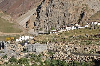 Road from Kaza entering Mud
 -
 Nyingma monastery, Mud
 -
 View down the Pin valley to Mud
 -
 Right bank of Pin river looking towards Mud, Jun '18
 -
 Hikers approach Mud on left bank of Pin
 -
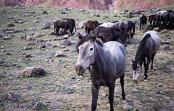 Chhumurthi horses near Mud
 -
 Sparse alpine vegetation, Jun '18
 -
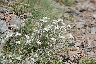 Sparse Alpine vegetation, Jun '18
 -
 Brandt's Mountain finch, Jun '18
 -
 Field of peas in Mud village, Jun '18
 -
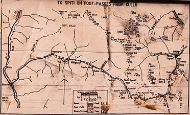 Trail from Mud to Kullu via the Pin Parbati Pass


See also
- Pin Bhaba Pass
- Pin Parbati Pass
- Pin Valley National Park
References
- ^ a b c d e f g h Fuchs, G. (June 1982). "The Geology of the Pin valley in Spiti, H. P., India". Jahrbuch der Geologischen Bundesanstalt. 124 (2): 325–359.
- ^ a b Stoliczka, F. (1866). "Geological Sections across the Himalayan Mountains from Wangtu Bridge on the River Sutlej to Sungdo on the Indus, with an account of the formations in Spiti, accompanied by a revision of all known fossils from that district". Memoirs of the Geological Survey of India. V. Geological Survey of India: 1–154.
- ^ Hayden, H.H. (1904). "The Geology of Spiti, with Parts of Bashahr and Rupshu". Memoirs of the Geological Survey of India. XXXVI, Part I (I). Calcutta: Geological Survey of India: 1–129.
- ^ from the original on 3 July 2022. Retrieved 3 July 2022.
- ^ S2CID 129814827.
- ^ "Pin Parbati trekking route". OpenStreetMap. Archived from the original on 10 July 2021. Retrieved 5 July 2021.
- ^ ISBN 0811729532.
- ^ "Kaza-Mud route". OpenStreetMap. Archived from the original on 10 July 2021. Retrieved 4 July 2021.
- ^ "Tabo-Mud route". OpenStreetMap. Archived from the original on 9 July 2021. Retrieved 4 July 2021.
- ^ a b c d District Census Handbook: Lahul & Spiti, Himachal -- Village and Town Directory. 3 Part XII A. Directorate of Census Operations, Himachal Pradesh, Ministry of Home Affairs, Govt of India. 2011.
- ISBN 978-81-7387-093-4. Archivedfrom the original on 2 September 2022. Retrieved 2 September 2022.
- ^ "Spiti Valley: Weather". Himachal Tourism. Department of Tourism and Civil Aviation, Government of Himachal Pradesh. 2019. Archived from the original on 4 August 2022. Retrieved 2 September 2022.
- ^ a b District Census Handbook: Lahul & Spiti, Himachal -- Village and Town Wise Primary Census Abstract (PCA). 3 Part XII B. Directorate of Census Operations, Himachal Pradesh, Ministry of Home Affairs, Govt of India. 2011.
- ^ "List of PRIs" (PDF). Panchayati Raj Department, HP Govt. Archived (PDF) from the original on 31 October 2020. Retrieved 25 January 2021.
- ^ Himachal Pradesh, Lahul and Spiti. "Locate Post Office". India Post. Archived from the original on 1 July 2021. Retrieved 4 July 2021.
- ^ "Sagnam-Mud Route". OpenStreetMap. Archived from the original on 10 July 2021. Retrieved 4 July 2021.
- ^ a b District Lahaul and Spiti, Tourism. "Pin Valley National Park". Lahaul and Spiti district. Archived from the original on 30 April 2021. Retrieved 4 July 2021.
- ISBN 9788187780335.
- ^ "Mud, Spiti - Wangtu, Kinnaur route". OpenStreetMap. Archived from the original on 10 July 2021. Retrieved 6 July 2021.
- ^ "NH-505 Attargo bridge-Mud Route". OpenStreetMap. Archived from the original on 9 July 2021. Retrieved 4 July 2021.
- The Tribune (Chandigarh). Archivedfrom the original on 12 February 2022. Retrieved 12 February 2022.
- ^ "Tara House Home Stay". Tripadvisor.in. Archived from the original on 9 July 2021. Retrieved 4 July 2021.
External links
- Lahaul and Spiti District website
 Media related to Mud village, Spiti at Wikimedia Commons