
Sandwich Harbour
| Sandwich Harbour | |
|---|---|
| Sandvishawe ( Afrikaans) | |
 Sandwich Harbour Location in Namibia | |
| Coordinates | 23°22′S 14°29′E / 23.367°S 14.483°E |
| Ocean/sea sources | Atlantic Ocean |
| Basin countries | Namibia |
| Max. length | 4.2 km (2.6 mi) |
| Max. width | 4 km (2.5 mi) |
| Designated | 23 August 1995 |
| Reference no. | 743[1] |
Sandwich Harbour (
Geography
Located about 80 km south of Walvis Bay, the area is within the Erongo Region. The bay opens to the north and is about 4.2 km long and 4 km wide. There is a shallow lagoon lying south of the bay, separated from it by an area of beach ridges and swales with saltpans.
The lagoon is 3.7 km in length and 1 km wide and is enveloped by sandy desert on its eastern side.[4] Former visitors to the area assumed that the water in the lagoon was fresh, but a recent survey found out that the lagoon is filled with poor quality brackish water that seeps under the dunes and allows the growth of large reed beds at the water's edge.[citation needed]
Sandwich Harbour was declared a Ramsar Site on 23 August 1995.

History
The area was surveyed in the 1880s by the
In the 1930s, an ambitious project was started to build a
Currently, the bay and lagoon are within the
Gallery
-
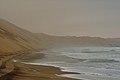
 The Sandwich Harbour seen from atop a sand dune
 -
 The Namibian desert's edge at Sandwich Harbour
 -
 The road leading to Sandwich Harbour
 -
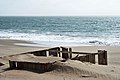 Remains of the guanu factory
 -
 Aerial view of the Sandwich Harbour


See also
References
- ^ "Sandwich Harbour". Ramsar Sites Information Service. Retrieved 25 April 2018.
- ^ "Sandwich Bay". Mapcarta. Retrieved 14 October 2016.
- ^ "Sandwich Harbour | Namibia". www.namibweb.com. Retrieved 2022-06-21.
- GoogleEarth
- ^ Namib-Naukluft Park
External links
 Media related to Sandwich Harbour at Wikimedia Commons
- First confirmed record of Lithognathus lithognathus sympatric with L. aureti
| Authority control databases: National |
|---|
This Namibia location article is a stub. You can help Wikipedia by expanding it. |