
Northern Thailand
This article needs additional citations for verification. (May 2017) |
Northern Region
ภาคเหนือ | |
|---|---|
   .jpg)  From upper-left to lower-right: Doi Inthanon, Doi Pha Hom Pok, Wat Phra That Doi Suthep, Fourth Thai–Lao Friendship Bridge and Phu Chi Fa | |
 Northern Region in Thailand | |
| Largest city | Chiang Mai |
| Provinces | 9 Provinces
|
| Area Palaungic • Southwestern Mandarin etc. | |
Northern Thailand, or more specifically Lanna, is geographically characterised by several mountain ranges, which continue from the Shan Hills in bordering Myanmar to Laos, and the river valleys that cut through them. Like most of Thailand, it has a tropical savanna climate, but its relatively high elevation and latitude contribute to more pronounced seasonal temperature variation, with cooler winters than the other regions.
Historically, northern Thailand has been linked to the
Geography
North Thailand is bound by the
Parallel mountain ranges extend from the Daen Lao Range (ทิวเขาแดนลาว), in the southern region of the Shan Hills, in a north–south direction, the Dawna Range (ทิวเขาดอยมอนกุจู) forming the western border of Thailand between Mae Hong Son and the Salween River.[7] To the east the Thanon Thong Chai Range (เทือกเขาถนนธงชัย), the Khun Tan Range (ทิวเขาขุนตาน), the Phi Pan Nam Range (ทิวเขาผีปันน้ำ), as well as the western part of the Luang Prabang Range (ทิวเขาหลวงพระบาง), form the natural region of the Thai highlands together with the former.[8]
The high mountains are incised by steep river valleys and upland areas that border the central plain. A series of rivers, including the
The four-region system includes the northern parts of the central plain as well as some mountainous areas bordering the western and the northeastern limits. The total forest area is 90,228 km2 (34,837 sq mi) or 52.5 percent of this four-region area.[1]


National parks
Within the northern region there are some sixty national parks. Chiang Mai Province has nine national parks of which Doi Inthanon National Park with the country's highest mountain and Op Luang National Park have a scenic river canyon, waterfalls, and caves. Doi Khun Tan National Park, which is located midway between the two provincial capitals of province Lampang and Lamphun, is best known for Thailand's longest railroad tunnel, which is 1,352 metres (4,436 ft) long. Doi Phu Kha National Park in province Nan is northern Thailand's largest national park.
Regional classification of northern Thailand
The northern region, as defined by the National Geographical Committee in 1978, consists of nine
In the
In 2019 it is common to subdivide the northern region into: nine provinces of the upper northern region and eight provinces of the lower northern region. All websites of these eight provinces state: "located in the lower northern region".

| Flag | Seal | Province | Capital | DOPA
|
Population | Area (km2) | Density | ISO | |
|---|---|---|---|---|---|---|---|---|---|

|

|
1 | Chiang Mai
|
Chiang Mai | 14 | 1,779,254 | 22,135 | 79 | TH-50 |

|

|
2 | Lamphun
|
Lamphun | 54 | 405,075 | 4,478 | 92 | TH-51 |

|

|
3 | Lampang
|
Lampang | 53 | 738,316 | 12,488 | 59 | TH-52 |

|

|
4 | Uttaradit
|
Uttaradit | 75 | 453,103 | 7,906 | 58 | TH-53 |

|
.svg)
|
5 | Phrae
|
Phrae | 41 | 441,726 | 6,483 | 68 | TH-54 |

|

|
6 | Nan
|
Nan | 26 | 478,227 | 12,130 | 40 | TH-55 |

|

|
7 | Phayao
|
Phayao | 34 | 472,356 | 6,189 | 76 | TH-56 |

|

|
8 | Chiang Rai
|
Chiang Rai | 13 | 1,298,304 | 11,503 | 113 | TH-57 |

|

|
9 | Mae Hong Son
|
Mae Hong Son | 45 | 284,138 | 12,765 | 23 | TH-58 |

|

|
10 | Nakhon Sawan
|
Nakhon Sawan | 23 | 1,059,887 | 9,526 | 111 | TH-60 |

|

|
11 | Uthai Thani
|
Uthai Thani | 76 | 328,618 | 6,647 | 50 | TH-61 |

|

|
12 | Kamphaeng Phet
|
Kamphaeng Phet | 5 | 725,867 | 8,5123 | 86 | TH-62 |

|

|
13 | Tak
|
Tak
|
17 | 665,620 | 17,303 | 39 | TH-63 |

|
.svg)
|
14 | Sukhothai
|
Sukhothai | 66 | 595,072 | 6,671 | 89 | TH-64 |

|

|
15 | Phitsanulok
|
Phitsanulok | 38 | 865,247 | 10,589 | 82 | TH-65 |

|

|
16 | Phichit
|
Phichit | 37 | 536,311 | 4,319 | 124 | TH-66 |

|

|
17 | Phetchabun
|
Phetchabun | 40 | 992,451 | 12,340 | 80 | TH-67 |
Economy
For FY 2018, Northern Thailand Region had a combined economic output of 1,266 trillion baht (US$40.8 billion), or 7.7 percent of Thailand's GDP. Lamphun province had an economic output of 84.395 billion baht (US$2.7 billion). This equates to a GPP per capita of 211,489 baht (US$6,822), half more than for Chiang Mai province, next in the ranking and double than for Lampang province, which is third in the ranking.[9]
| Rank | Province | GPP (million baht) |
Population (x 1000) |
GPP per capita (baht) |
|---|---|---|---|---|
| 1 | Lamphun | 84,395 | 399 | 211,489 |
| 2 | Chiang Mai | 247,831 | 1,805 | 137,316 |
| 3 | Lampang | 71,950 | 714 | 100,709 |
| 4 | Phayao | 37,298 | 383 | 97,306 |
| 5 | Chiang Rai | 110,815 | 1,156 | 95,895 |
| 6 | Uttaradit | 39,190 | 416 | 94,260 |
| 7 | Phrae | 30,403 | 388 | 78,276 |
| 8 | Nan | 33,674 | 445 | 75,676 |
| 9 | Mae Hong Son | 13,728 | 235 | 58,370 |
| Upper provinces | 669,284 | 5,941 | 112,655 |
Graphs are unavailable due to technical issues. There is more info on Phabricator and on MediaWiki.org. |
Kamphaeng Phet province had an economic output of 117.705 billion baht (US$3.8 billion). This amounts to a GPP per capita of 150,783 baht (US$4,864), half more than for Tak province, which is fifth in the ranking.
| Rank | Province | GPP (million baht) |
Population (x 1000) |
GPP per capita (baht) |
|---|---|---|---|---|
| 1 | Kamphaeng Phet | 117,705 | 781 | 150,783 |
| 2 | Nakhon Sawan | 116,147 | 938 | 123,865 |
| 3 | Phitsanulok | 100,286 | 896 | 111,872 |
| 4 | Uthai Thani | 29,879 | 281 | 106,369 |
| 5 | Tak | 52,720 | 532 | 99,026 |
| 6 | Phichit | 48,347 | 518 | 93,265 |
| 7 | Phetchabun | 81,909 | 921 | 88,971 |
| 8 | Sukhothai | 50,384 | 613 | 82,147 |
| Lower provinces | 597,377 | 5,480 | 109,010 |
Graphs are unavailable due to technical issues. There is more info on Phabricator and on MediaWiki.org. |
Languages
The main language is Northern Thai, which is a southwestern Tai language spoken in the 9 changwat of Northern Thailand. It is spoken by roughly six million people. There are also various hill tribe languages such as Lolo-Burmese, Karenic, Mienic, Mienic, Palaungic, Southwestern Mandarin.
Notes
- There was no population survey in 2020 due to COVID-19.
- Ethnic communities in northern Thailand
-
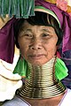 Kayan woman
 -
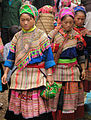 Hmong women
 -
 River woman
 -
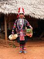 Akha woman


.jpg)

See also
References
- ^ a b "ตารางที่ 2 พี้นที่ป่าไม้ แยกรายจังหวัด พ.ศ.2562" [Table 2 Forest area Separate province year 2019]. Royal Forest Department (in Thai). 2019. Retrieved 6 April 2021, information, Forest statistics Year 2019, Thailand boundary from Department of Provincial Administration in 2013
{{cite web}}: CS1 maint: postscript (link) - ^ รายงานสถิติจำนวนประชากรและบ้านประจำปี พ.ส.2562 [Statistics, population and house statistics for the year 2019]. Registration Office Department of the Interior, Ministry of the Interior. stat.bora.dopa.go.th (in Thai). 31 December 2019. Retrieved 26 February 2020.
- ISSN 1686-0799. Retrieved 22 January 2020.
- ^ Tan, Heidi (2012), "The Many Streams of Buddhist Art in Thailand", Enlightened Ways: The Many Streams of Buddhist Art in Thailand, Asian Art Museum of San Francisco, p. 13
- ^ Smith, John (2019). State, Community, and Ethnicity in Early Modern Thailand, 1351-1767 (PDF) (Ph.D. dissertation). University of Michigan. p. 40. Retrieved 2023-04-08.
- ^ Forest data: Thailand Deforestation Rates
- ^ Northern Thailand Archived 2012-01-28 at the Wayback Machine
- ^ ดร.กระมล ทองธรรมชาติ และคณะ, สังคมศึกษา ศาสนาและวัฒนธรรม ม.1, สำนักพิมพ์ อักษรเจริญทัศน์ อจท. จำกัด, 2548, หน้า 24-25
- ISSN 1905-8314.
External links
 North (Thailand) travel guide from Wikivoyage
 | Four-region division system |  | |
|---|---|---|---|
| Six-region division system | |||