
Notre Dame Island
Saint Lawrence River | |
| Coordinates | 45°30′15″N 73°31′35″W / 45.50417°N 73.52639°W |
|---|---|
| Administration | |
| Province | Quebec |
| City | Montreal |
| Borough | Ville-Marie |
| Demographics | |
| Population | 0 |
Notre Dame Island (
Parc Jean-Drapeau is registered as a leg of the
History
Notre Dame Island was built in ten months from 15 million tons of rock excavated for the Montreal Metro in the early 1960s. It was created for Expo 67 to celebrate Canada's centennial.[1][2]
Nearly all of the remaining Expo 67 pavilions were demolished in 1975 to make way for a long
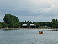
The park area on the island's southern tip has a small lake with a beach open throughout the summer for swimming, volleyball and watercraft rentals. During the decades since Expo 67, the city of Montreal has embellished the island with plants and trees, making it look less artificial.
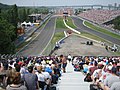
In 1978, Circuit Île Notre-Dame was opened, which uses the roads of the island for motorsport events in the summer months.[3] The circuit was renamed in 1982 after Canadian Formula One driver Gilles Villeneuve following his death earlier that year.[4]
In 1980, the greening and beautification of the island was accelerated when it was the host to the Floralies Internationales, a horticultural exhibition and competition gathering plant masterpieces from dozens of countries. Still accessible today from spring to autumn, these gardens cover over 25 hectares (62 acres). The Floralies gardens are preserved and arranged creatively by the Parc Jean-Drapeau team of gardeners. In addition, the micro-climate created in part by the lagoons crisscrossing the island promotes the uniqueness of these gardens by allowing plants usually intolerant of Montreal's cold climate to grow.
The park hosted the ICF Canoe Sprint World Championships in 1986.
Off-season
In fall and spring, visitors to Notre Dame Island primarily consist of gamblers at the casino and rowers and
can also tour the area.Circuit Gilles Villeneuve
Each summer, Notre-Dame Island's
-
 Kwakiutl Totem pole
 -
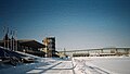 The Olympic Basin in the winter
 -
-
 The Montreal Casino
 -
 The beach during the summer
 -
 La Maison d'Autrefois du Québec
 -
 Casino de Montréal, photographed in 1996.
.jpg)


.jpg)

.jpg)

See also
- Land reclamation
- List of islands of Quebec
References
- ^ Banter, Bill (29 March 1963). "'Dazzling' future viewed for Saint Helen's Fair site". Montreal Gazette. p. 1.
- ^ "Au printemps 1967, on inaugurait la nouvelle ligne jaune du métro de Montréal". Radio-Canada (in Canadian French). 2022-03-30. Retrieved 2023-08-16.
- ^ Automobile Year, 1978/79, page 235
- ^ Peter Higham, The Guinness Guide to International Motor Racing, 1995, Page 362
- ^ "Circuit Gilles Villeneuve" (in Canadian French). Archived from the original on September 2, 2011. Retrieved September 5, 2011.
- 1976 Summer Olympics official report. Volume 2. pp. 112–7.
- Gray, Jeremy. Montreal. Lonely Planet, 2004. p. 50 and 59.
- Frommer, Arthur. Montreal and Quebec City, 2007. p. 65.
- McKay, Emma ed. Montreal and Quebec City. Colour guide, 2005. p. 23.
- Ulysses Travel Guides. Collective (2007). Montreal. Montreal: ulyssesguides.com. ) pp. 189–190
External links
| Montreal Olympic Park |  | |
|---|---|---|
| Greater Montreal | ||
| Football venues | ||
| Handball venues | ||
| Other venues | ||
_pictogram.svg)

| Authority control databases: Geographic |
|---|