
Piloting
Piloting or pilotage
Piloting references
Charts
Depending on whether one is navigating on a water course, in the air or on land, a different chart applies for the navigator:
- Nautical charts – show coastal regions and depict depths of water and land features, natural features of the seabed, details of the coastline, navigational hazards, locations of natural and human-made aids to navigation, and human-made structures such as harbours, buildings and bridges.
- Aeronautical charts – for visual meteorological conditions depict terrain, geographic features, navigational aids and other aids to navigation. They vary in scale from 1:1,000,000 for world aeronautical charts to 1:250,000.
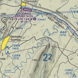
- Topographic maps – show landforms and terrain, lakes and rivers, forest cover, administrative areas, populated areas, roads and railways, and other man-made features.[8]
- Cartography showing man-made and natural features that can be used as points of reference appropriate to the type of navigation.
-
 Nautical chart – includes water depth.
 -
 Aeronautical chart – includes elevation.
 -
 Topographic map – emphasizes contours – suitable for land navigation.


Maritime piloting
Coastal mariners often use reference manuals, called "pilots" for navigating coastal waters. In addition to providing descriptions of shipping channels and coastal profiles, they discuss weather, currents and other topics of interest to mariners. Notable guides include a worldwide series of "Sailing Directions" by the United Kingdom Hydrographic Office (formerly by the British Admiralty) that includes, most notably, the English Channel, the Mediterranean Sea, the Red Sea and the Persian Gulf.[9] Another series worldwide series of Sailing Directions is by the US National Geospatial-Intelligence Agency,[10] which has planning guide and enroute portions. The "United States Coast Pilot", by the National Oceanic and Atmospheric Administration (NOAA) Office of Coast Survey, covers the coastal and intracoastal waters and the Great Lakes of the United States.[11]
Points of reference
Common types of visual reference point used for piloting and pilotage include:[12]
Day
- Natural features: Mountains, hills, lakes, rivers and coastal features such as cliffs, rocks and beaches
- Other structures: antennas
Night
- Lighted navigational aids: lightvesselsand lighted sea marks
- Lighted structures: Airports, illuminated towers and buildings
Vertical
Depth, measured with a
Fix of position


Instruments used
On shipboard, navigators may use a
Afloat
Mariners use
Usually, a fix is where two or more position lines intersect at any given time. If three position lines can be obtained, the resulting "cocked hat", where the 3 lines do not intersect at the same point, but create a triangle where the vessel is inside, gives the navigator an indication of the accuracy in the three separate position lines.[5]
If two geographic features are visually aligned (the edge of an island aligned with the edge of an island behind, a flag pole and a building, etc.), the extension of the line joining the features is called a "transit". A transit is not affected by compass accuracy, and is often used to check a compass for errors.[14]
The most accurate fixes occur when the position lines are at right angles to each other.[5]
Aloft
Flying at low altitudes and with sufficient visibility, aircraft pilots use nearby rivers, roads, railroad tracks and other visual references to establish their position.[4]
Course versus ground track
The line connecting fixes is the track over the ground or sea bottom. The navigator compares the ground track with the navigational course for that leg of the intended route, in order to make a correction in "heading", the direction in which the craft is pointed to maintain its course in compensation for cross-currents of wind or water that may carry the craft off course.[5]
In channels and rivers

Where a channel is narrow, as in some harbor entrances and on some rivers, a system of
See also
- Navigation – Process of monitoring and controlling the movement of a craft or vehicle from one place to another
- Celestial navigation – Navigation using astronomical objects to determine position
- Dead reckoning – Means of calculating position
- Radio navigation – Use of radio-frequency electromagnetic waves to determine position on the Earth's surface
- Satellite navigation– Use of satellite signals for geo-spatial positioning
- Land navigation – discipline of following a route through unfamiliar terrain on foot or by vehicle
- Maritime pilot – Mariner who maneuvers ships through dangerous or congested waters
- Pilot (aeronautics)– Person controlling an aircraft in flight
- Underwater navigation by divers– Underwater navigation by scuba divers
- Bowditch's American Practical Navigator – Encyclopedia of maritime navigation
References
- ^ a b Collins English Dictionary
- ^ a b American Heritage Dictionary
- ISBN 1-58816-089-0.
- ^ National Aeronautics and Space Administration. Archived from the originalon 2016-05-08. Retrieved 2016-05-13.
Pilotage: A method of navigation in which the pilot, flying at low altitudes, uses visual references and compares symbols on aeronautical charts with surface features on the ground in order to navigate.
- ^ ISBN 978-0-7136-8939-6
- ISBN 978-1-4209-2823-5.
- ^ UK Divers (October 16, 2007). "Underwater Navigation". UKDivers.net. Archived from the original on March 13, 2016. Retrieved 2016-05-16.
Pilotage – Navigation by reference to terrain features, both natural and artificial, usually with the aid of an appropriate chart.
- ^ Government of Canada (2016-04-08). "National Topographic System Maps". Earth Sciences – Geography. Natural Resources Canada. Retrieved 2016-05-16.
- ^ Hydrographic Office (2015). "Admiralty Nautical Products and Services – Paper publications". United Kingdom. Retrieved 2016-05-19.
Often referred to as Pilots, Sailing Directions are designed for use by the merchant mariner on all classes of ocean-going vessels with essential information on all aspects of navigation. Sailing Directions are complementary to ADMIRALTY Standard Nautical Charts and provide worldwide coverage in 75 volumes.
- ^ National Geospatial-Intelligence Agency. "Sailing Directions Enroute". Maritime Safety Information. National Geospatial-Intelligence Agency. Retrieved 2016-05-19.
Sailing Directions (Enroute) include detailed coastal and port approach information, supplementing the largest scale chart of the area. Each publication is subdivided into geographic regions, called sectors, which contain information about the coastal weather, currents, ice, dangers, features and ports, as well as a graphic key to the charts available for the area.
- ^ Office of Coast Survey. "United States Coast Pilot®". Nautical Charts & Pubs. National Oceanic and Atmospheric Administration. Retrieved 2016-05-19.
The United States Coast Pilot® consists of a series of nautical books that cover a variety of information important to navigators of coastal and intracoastal waters and the Great Lakes. Issued in nine volumes, they contain supplemental information that is difficult to portray on a nautical chart.
- ^ ISBN 978-0-939837-54-0
- ^ Frazer, Persifor, A Convenient Device to be Applied to the Hand Compass, Proceedings of the American Philosophical Society, Vol. 22, No. 118 (Mar., 1885), p. 216
- ISBN 978-0-470-51613-3, retrieved 2016-05-08
- ^ United States Coast Guard Auxiliary (December 19, 2013), National Short Range Aids to Navigation – Training Guide (PDF), Washington: United States Coast Guard, p. 28, retrieved 2016-05-08