
Puerto Rico Highway 167
Highway 167 | ||||
|---|---|---|---|---|
| Ruta 167 | ||||
| Route information | ||||
| Maintained by Puerto Rico DTPW | ||||
| Length | 28.4 km[1] (17.6 mi) | |||
| Existed | 1953[2]–present | |||
| Major junctions | ||||
| South end | ||||
| ||||
| North end | ||||
| Location | ||||
| Country | United States | |||
| Territory | Puerto Rico | |||
| Municipalities | Comerío, Naranjito, Toa Alta, Bayamón, Cataño, Toa Baja | |||
| Highway system | ||||
| ||||


Puerto Rico Highway 167 (PR-167) is one of the main highways in the San Juan–Caguas–Guaynabo metropolitan area of Puerto Rico. Highway 167 starts at Puerto Rico Highway 165 in Levittown and goes until Puerto Rico Highway 156 in Comerío.
Route description
It is two-lane per direction all through Cataño and a vast area of Bayamón, and becomes rural a couple of kilometers before entering Naranjito. During the rainy season this road is risky as there is chance of rock fall and debris onto the road. This occurs mainly due to an increase in the moisture content of the soil, which loosens the suspended rocks adjacent to the highway. It has been proposed to make this road fully parallel to the future tollway PR-5, which will be extended until Comerío. The future tollway will pass through the only cable-suspended bridge in the island in Bayamón near the border with Naranjito.[3]
The
-
 Comerío Road (circa 1900–1917)
 -
 Plata Bridge from PR-167


Major intersections
-
 PR-167 south approaching PR-29 junction in Hato Tejas, Bayamón
 -
 PR-167 south at PR-22 junction in Río Hondo, Bayamón
 -
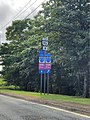
 Signs for PR-22 and PR-167 in Levittown, Toa Baja
.jpg)

.jpg)
| Municipality | Location | km[1] | mi | Destinations | Notes | |||
|---|---|---|---|---|---|---|---|---|
Doña Elena | 0.0 | 0.0 | Southern terminus of PR-167 | |||||
| 1.9 | 1.2 | Doña Elena | ||||||
| Naranjito | Nuevo | 5.3– 5.4 | 3.3– 3.4 | |||||
| 8.5 | 5.3 | Guadiana | ||||||
| Río de la Plata | 8.5– 8.6 | 5.3– 5.3 | Puente Plata[5] | |||||
Dajaos | 8.9 | 5.5 | ||||||
| 10.1 | 6.3 | Dajaos | ||||||
Ortíz | ||||||||
Ortíz | ||||||||
| 14.3 | 8.9 | Ortíz | Western terminus of PR-829 concurrency | |||||
| 14.4 | 8.9 | Eastern terminus of PR-829 concurrency | ||||||
| 15.4 | 9.6 | |||||||
Pájaros | 17.3 | 10.7 | ||||||
| 19.2 | 11.9 | |||||||
| Cerro Gordo | 20.1 | 12.5 | PR-Avenida Magnolia – Bayamón | |||||
| 21.6 | 13.4 | PR-Avenida Doctor Ramón Luis Rodríguez – Bayamón | ||||||
Bayamón barrio-pueblo | 22.2 | 13.8 | ||||||
| 22.4– 22.5 | 13.9– 14.0 | One-way street ; westbound access via Calle Ramón Emeterio Betances | ||||||
Hato Tejas | 22.8 | 14.2 | ||||||
| 23.2 | 14.4 | |||||||
| 25.1 | 15.6 | PR-22 exit 13; diamond interchange | ||||||
| Cataño |
No major junctions | |||||||
Sabana Seca | 26.9– 27.0 | 16.7– 16.8 | PR-Avenida Juan "Picolino" Hernández Ferrer – Toa Baja | |||||
| 27.8– 27.9 | 17.3– 17.3 | |||||||
| 28.4 | 17.6 | Northern terminus of PR-167 | ||||||
1.000 mi = 1.609 km; 1.000 km = 0.621 mi
| ||||||||
In popular culture
Puerto Rican rapper and singer Farruko's seventh studio album, La 167, is named after PR-167. Puerto Rico Highway 167 runs near Bayamón, where Farruko grew up.[6]
See also
 U.S. Roads portal
References
- ^ a b Google (13 March 2020). "PR-167" (Map). Google Maps. Google. Retrieved 13 March 2020.
- ^ "Comerío, Memoria Núm. 41" (PDF). Puerto Rico Planning Board (in Spanish). 1955. Retrieved 4 August 2020.
- ^ "Tránsito Promedio Diario (AADT)". Transit Data (Datos de Transito) (in Spanish). DTOP PR. pp. 88–89. Archived from the original on 1 April 2019.
- ^ Luis Pumarada O'Neill and PRSHPO (31 July 1994). "Plata Bridge". National Park Service. Retrieved 16 May 2016. with 3 photos from 1993
- ^ Luis F. Pumarada O’Neill (1991). "Los Puentes Históricos de Puerto Rico" (PDF) (in Spanish). pp. 101–102. Retrieved 13 March 2020.
- ^ "Multi-Platinum Singer-Songwriter FARRUKO Drops "LA 167" Album". Audible Treats. 1 October 2021.
External links
 Media related to Puerto Rico Highway 167 at Wikimedia Commons
This Puerto Rican location article is a stub. You can help Wikipedia by expanding it. |
This Puerto Rico road-related article is a stub. You can help Wikipedia by expanding it. |