
Qubadli
Qubadli
Qubadlı | |
|---|---|
UTC+4 (AZT) | |
| Area code | +994 133 |
Qubadli[a] (Azerbaijani: Qubadlı, pronounced [gubɑdˈlɯ] ⓘ) is a city in Azerbaijan and the administrative centre of the Qubadli District. It is situated along the Vorotan (Bargushad) river.
History
Qubadli was part of the
Shiite branch of Islam in Qubadli.[2] According to the 1912 publication of the Caucasian Calendar, the village of Qubadli was home to 672 people, the majority of whom were Azerbaijanis (classified as "Tatars" in the census).[3]
During the Soviet era, Qubadli was first a part of
Kurdistansky Uyezd. During the early Soviet period in 1933, Qubadli was part of the village council of the same name in the Zangilan District. There were 88 farms in the village and a population of 346 people. The population of the village council, which included the villages of Gödəklər, Mahmudlu, and Qayalı, was 97.1 percent Azerbaijani.[4]
Qubadli was granted
Soviet Census of 1989.[7]
During the
2020 Nagorno-Karabakh War.[8]
Demographics
| Year | Population | Ethnic composition | Source | ||||||||
|---|---|---|---|---|---|---|---|---|---|---|---|
| 1886 | 326 | 100% Tatars (i.e. Azerbaijanis) | Transcaucasian Statistical Committee[2] | ||||||||
| 1912 | 672 | Mainly Tatars | Caucasian Calendar[3] | ||||||||
| 1939 | 1,017 | 84.2% Azerbaijanis, 8.3% Russians, 5.9% Armenians | Soviet Census[9]
| ||||||||
| 1970 | 2,669 | 99.1% Azerbaijanis, 0.4% Russians, 0.4% Armenians | Soviet Census[10]
| ||||||||
| 1979 | 3,392 | 99.3% Azerbaijanis, 0.2% Russians, 0.1% Armenians | Soviet Census[11]
| ||||||||
| 1989 | 5,508 | Soviet Census[7]
| |||||||||
| 1991 | ~5,800 | Great Encyclopedic Dictionary[12] | |||||||||
| 31 August 1993: Occupation of Qubadli. Expulsion of Azerbaijani population | |||||||||||
| 2015 | 600 | ~100% Armenians | NKR estimate[1] | ||||||||
Notable natives
- Chingiz Ildyrym — People's Commissar for Military and Naval Affairs of the Azerbaijan SSR (1920).[13]
- Vasili Aliyev — National Hero of Azerbaijan[14]
- Niyamaddin Pashayev — Taekwando, World and European Champion[15]
- Heydar Mammadaliyev — Wrestling, World Champion, 2004 Olympicsilver medalist
- Shukur Hamidov — National Hero of Azerbaijan
- Aliyar Aliyev — National Hero of Azerbaijan
- Armed Forces of Azerbaijan
Gallery
-
 Sign at the entrance of the city
 -
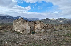
 Ruined building in Qubadli
 -
 Aerial view of Qubadli
 -
-
-
 Ruins of Qubadli
 -
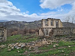
 Ruined homes in Qubadli

,_Building,_2014.05.09_-_panoramio.jpg)


References
- ^ Also anglicized as Gubadly or Gubadli
- ^ a b "Urban communities of the NKR" (PDF). stat-nkr.am. National Statistical Service of Nagorno-Karabakh Republic. 1 January 2015. p. 13.
- ^ a b Свод статистических данных о населении Закавказскаго края, извлеченных из посемейных списков 1886 г. Tiflis: Transcaucasian Statistical Committee. 1893. p. 251.
- ^ a b Кавказский календарь на 1912 год [Caucasian calendar for 1912] (in Russian) (67th ed.). Tiflis: Tipografiya kantselyarii Ye.I.V. na Kavkaze, kazenny dom. 1912. p. 174. Archived from the original on 11 December 2021.
- ^ Административное деление АССР [Administrative divisions of the ASSR] (in Russian). AzUNKHU. 1933. p. 101.
- ^ a b "ГУБАДЛЫ". Azerbaijani Soviet Encyclopedia. Vol. 3. Baku. 1979. p. 254.
{{cite encyclopedia}}: CS1 maint: location missing publisher (link) - ^ a b "Rayon haqqında". Azərbaycan Respublikası Qubadlı Rayon İcra Hakimiyyəti (in Azerbaijani). Retrieved 17 June 2022.
- ^ a b "Всесоюзная перепись населения 1989 г." www.ethno-kavkaz.narod.ru.
- BBC Russian Service. 26 October 2020. Retrieved 26 October 2020.
- ^ "Этнокавказ. Национальный состав населения Губадлинского района по переписи 1939 года".
- ^ "Этнокавказ. Национальный состав населения Губадлинского района по переписи 1970 года".
- ^ "Этнокавказ. Национальный состав населения Губадлинского района по переписи 1979 года".
- ^ "КУБАТЛЫ" [KUBATLY]. Great Encyclopedic Dictionary. Moscow. 2000.
{{cite encyclopedia}}: CS1 maint: location missing publisher (link) - ^ Активные борцы за советскую власть в Азербайджане. Азербайджанское гос. изд-во. 1957. p. 226.
- ^ "Aliyev Vasili Ahmad oglu". milliqahraman.az.[permanent dead link]
- ^ "TaekwondoData". TaekwondoData.
External links
Wikimedia Commons has media related to Qubadlı.


| Authority control databases: National |
|---|