The Rayen Castle (Persian: ارگ راينArg-e Rāyen) is a historic adobe fortress situated on the outskirts of the Hezar Masjed Mountains, about 100 kilometers south of Kerman province, Iran. The castle and the mudbrick city it protects display numerous architectural elements and design strategies recognized as hallmarks of Iranian citadels. The complex is well preserved despite numerous natural disasters that have destroyed similar structures nearby, including Arg-e Bam, which was destroyed in an earthquake in December 2003.
Rayen is assumed to have been inhabited until 1868. Although believed to be at least 1,000 years old, it may have foundations dating to the pre-Islamic


 Castle's gate
 Inside of the castle
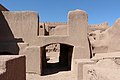
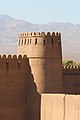 A tower of the castle


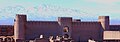
 View at night


.jpg)


.jpg)
.jpg)
.jpg)


