
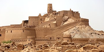
Arg-e Bam
| UNESCO World Heritage Site | |
|---|---|
 | |
| Location | Bam, Iran |
| Part of | Bam and its Cultural Landscape |
| Criteria | Cultural: ii, iii, iv, v |
| Reference | 1208 |
| Inscription | 2004 (28th Session) |
| Endangered | 2004–2013 |
| Coordinates | 29°07′01″N 58°22′07″E / 29.11694°N 58.36861°E |
 Location of Arg-e Bam in Iran  Arg-e Bam (West and Central Asia) | |


The Arg-e Bam (
Listed by UNESCO as part of the World Heritage Site "Bam and its Cultural Landscape", it can be traced back to at least the Achaemenid Empire (sixth to fourth centuries BC). The citadel rose to importance from the seventh to eleventh centuries, as a crossroads along the Silk Road and other important trade routes, and as a producer of silk and cotton garments.[1]
On 26 December 2003, the citadel was almost completely destroyed by an earthquake, along with much of the rest of Bam and its environs. A few days after the earthquake, the President of Iran, Mohammad Khatami, announced that the citadel would be rebuilt.
History
There is no precise archaeological dating of the buildings of the Citadel of Bam.
During the
In 645 AD, the Kerman region was conquered by the
After the Mongol invasion of Iran, Bam and the Kerman region were turned over to the Qarakhataian dynasty, who ruled the region from 1240 to 1363 AD. Bam benefited from a strategic location on the spice route, connecting the region to the Silk Road. The city was renowned for silkworm breeding and a flourishing silk industry.[2]
During the
The citadel was used as a garrison until 1932; however, since then, the garrison and old city have been abandoned. In 1953, the site became recognized as a nationally significant historic site, and a gradual process of conservation and restoration began; however, most of the work was carried out from 1973 onwards.[2]
After the
Citadel design and architecture
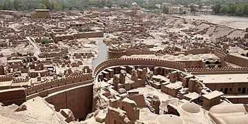
The citadel is situated in the center of the fortress-city, on the point with the widest view, for security.
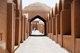
All buildings are made of non-baked clay bricks, i.e. adobe. Prior to the 2003 earthquake, Bam Citadel was most likely the largest adobe structure in the world.[1][2]
In 1976, the Citadel was used as the major location site for Valerio Zurlini's film, The Desert of the Tartars.
Description of the citadel
The citadel consists of four main sections: a
Arg-e-Bam had 38
Dimensions
Larger than the nearby Rayen Castle, the area of Bam Citadel is approximately 180,000 square meters (44 acres) and is surrounded by gigantic walls, 6–7 metres (20–23 ft) high and 1,815 metres (5,955 ft) long.
2003 earthquake
On 26 December 2003, at 5:26 am, Bam was struck by a major earthquake. The United States Geological Survey estimated its magnitude at 6.6, on the Richter scale. It also had a vertical acceleration of 1G. About 142,000 people were living in the Bam area, at the time. The extremely destructive quake killed about 26,200, injured thousands, and left more than 75,000 homeless. Approximately 70% of the buildings were destroyed. The earthquake was wrenching because its hypocenter was located just below the city of Bam, around 7 km deep.[2]
The Bam area has an underground base consisting of a series of faults. The main one, called Bam Fault, had been inactive for a very long time. Though the earthquake was on the southern part of Bam, the main direction of the horizontal motion of the waves was East-West and was perpendicular to the direction of the main fault located around 3 km East of Bam. It seems that the Bam Fault channeled the energy of the earthquake in its direction, North-South, but at the same time, it acted like a boomerang or amplifier by sending back the energy on an East-West direction.[2]
This was noted on the various sites where buildings which were mostly ruined had their main axis oriented North-South (Arg-e-Bam, Bam and the villages on the East of Bam). Therefore, they could not withstand the waves coming from the East (Bam) or West (villages east of Bam) and perpendicular to them.[2]
Buildings that had their main axis oriented East-West were in the same direction of the seismic waves and they responded much better; some of their parts were damaged, but they were not totally ruined. They also presented the typical shear cracks when the ground motion is in the direction of the wall plane.[2]
The structures that had been maintained and repeatedly modified or expanded over time fared much worse than did the ancient structures that had not been maintained, modified, or restored. The same intriguing phenomenon could be observed on the structures partially or entirely strengthened and restored during the late 20th century.[2]

Consequences of the earthquake
The citadel, including the governor’s residence, the main tower, the Chahar Fasl (Four Seasons) turret, and the hammam, were nearly totally destroyed, especially because of their location on top of the hill. The rocky hill concentrated the energy of the earthquake. In addition, these buildings collapsed because their foundations were resting on inhomogeneous ground, made of rocks and earth filling. The earth filling slipped with the ground motion. The city at the foot of the castle was nearly flattened, especially the parts that previously had been restored. Most of the vaulted roofs were cracked or severely damaged.[2]
No restoration had been undertaken for the Konariha quarter, before the earthquake. It was already severely ruined, and there were just a few structures left, of eroded vaults and domes. Paradoxically, this part of the city had less damage than the part which had been restored, though the ramparts all around collapsed. Only a few walls collapsed and some remnants, of already broken vaulted roofs, fell down.[2]
No restoration had been undertaken either for the
Three kilometers east of Arg-e-Bam are the Summer Pavilion, Kushk Rahim Abad, and an old caravanserai. Both were not damaged further by the earthquake. The summer pavilion was already severely ruined before the earthquake. The old caravanserai had been abandoned long ago, and some of its parts had previously collapsed. In fact, the earthquake damaged this caravanserai very little, compared to the average situation in Arg-e-Bam, Bam, and the villages further east. The reason seemed that it was well built with sound details, compared to the average building quality of the area.[2]
Gallery
- Arg-e Bam
-
-

-

-
-
-


See also
References
- The original text was a translation by of the article "Bam-Citadelo", originally written in Esperanto language by Asad Mahbub, first appeared in Irana Esperantisto (Iranian Esperantist), No. 4, Year 2, Summer 2003, 40 p., pp. 5–7. Permission has been granted for its use in Wikipedia. Its sources were:
- Nimrokhi az Arge Bam (Bam Citadel at a Glance), by Davood Yousofzadeh, Bam: M. Mohammadi-zade, 1998, p. 160.
External links
- Bam and its Cultural Landscape (World Heritage List)
- Bam Citadel site, with photos
- The Bam Citadel – documentary film (in English)
- Newspaper item: "The Lost Beauty that was Bam"
- Photos of the Bam Citadel
- More photos of the citadel
- Iran Cultural Heritage Organisation Site on Arge Bam Archived 2009-05-25 at the Wayback Machine
- Iran Cultural Heritage Organisation Site – Reconstruction Photos
- High-resolution 360° Panoramas of the Bam Citadel | Art Atlas


.jpg)


.jpg)
.jpg)
| National | |
|---|---|
| Geographic | |